Broadway Complete Streets update

Additional posts on Broadway Complete Streets are available at category ‘Broadway Complete Streets‘.

Green Paint

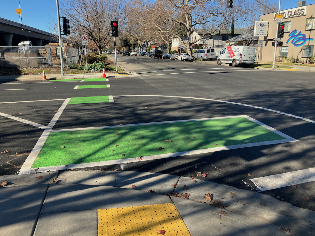
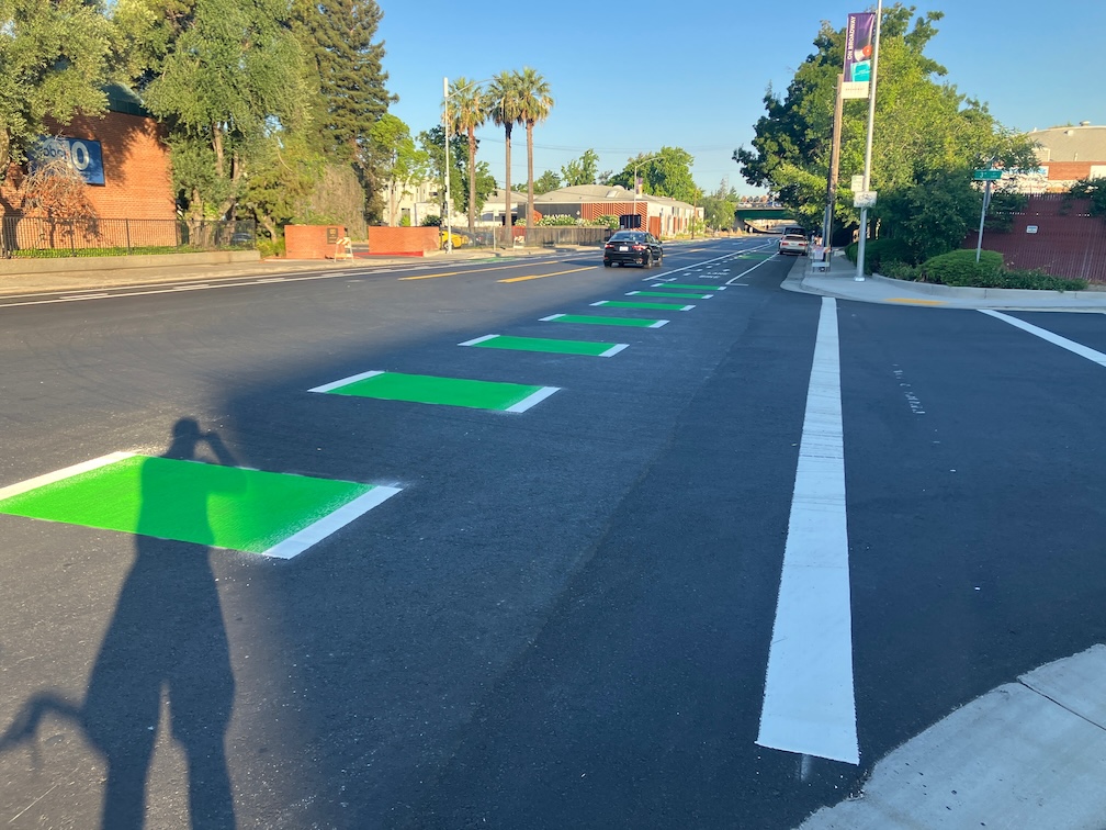
Green paint has been added to parts of the Broadway Complete Streets project, mostly to the west of Riverside Drive/11th Street, and some to the west of Land Park Drive/16th Street. I did not see any green paint east of Land Park Drive/16th Street. Several areas marked for green paint have not yet been painted, so this aspect of the project is certainly not complete. Where it has been completed, it is pretty nice, well done.

Broadway at 3rd St, bike lane with skipped green marking

Several bus stops have been or will be marked with extra wide green paint, indicating a shared bus and bike area. For most of Broadway, the bus is SacRT Route 51, with a frequency of 15 minutes, but from 9th Street to Riverside Drive/11th St, SacRT Route 11 is also present. Shown below is the bus stop just before 10th Street, which is the only transfer point between routes 11 and 51, and was destined to be removed by the city before SacRT complained. The bus stop should have been moved to just beyond 10th Street, and served with a bus boarding extension, but this is better than nothing.

Broadway at 10th St, shared bus stop and bike lane green marking

It is worth remembering that green paint has no legal meaning. It is informational, meant to mark potential conflict areas between motor vehicles and bicyclists. As such, it is worthwhile, but bicyclists should always remember to be situationally aware and to not think of green paint (or any paint) as protective.

16th Street Conversion

The block of 16th Street between Broadway and X Street has been converted from one-way to two-way. This may have happened a while ago, and I missed it, but below is a photo from today. The conversion is an attempt to encourage drivers to use X Street eastbound to access Broadway to the east of 16th Street, or Land Park Drive.

conversion one-way to two-way, 16th St between Broadway and X St

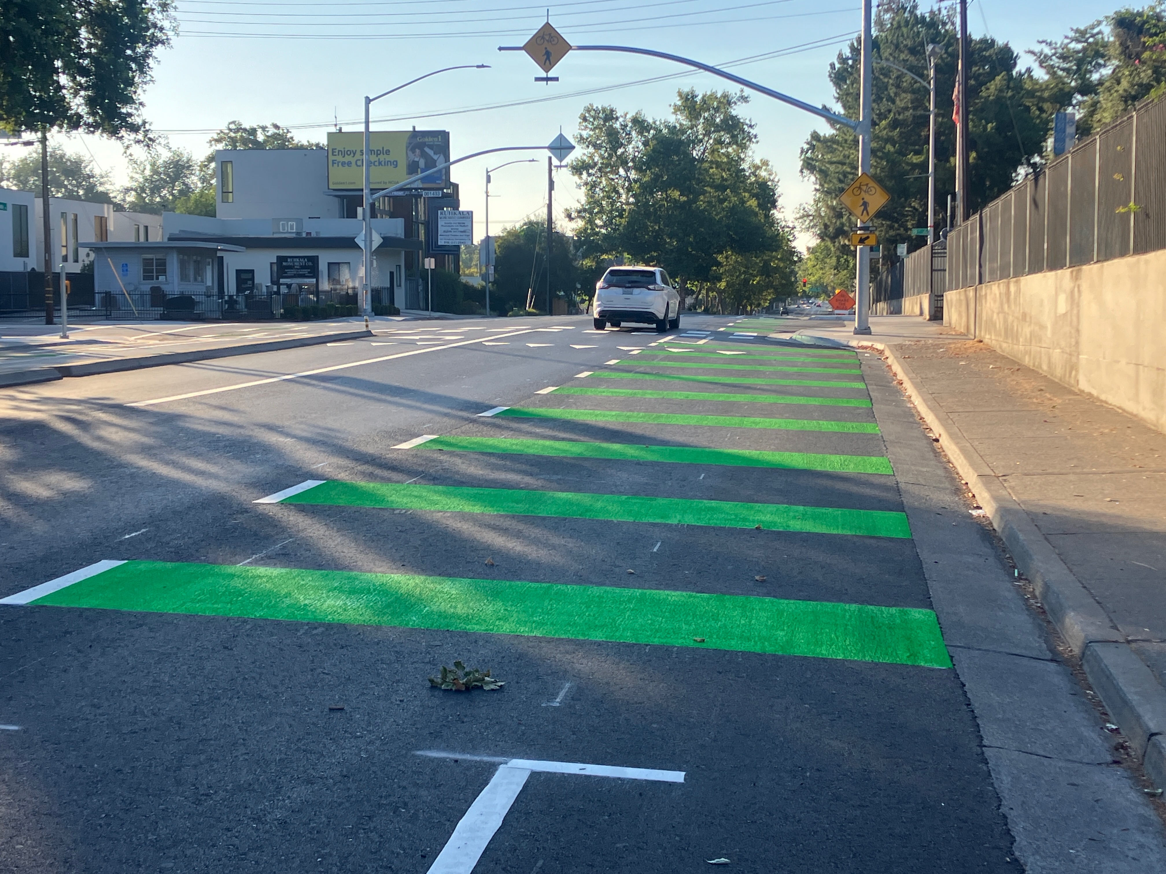
Confusion approaching 16th Street

I spent time today observing driver behavior, turning right from Broadway westbound onto 16th Street. Some drivers pulled to the curb, over the bike lane. This is actually the correct legal behavior under California law, to turn from as close to the curb as reasonable, however, many drivers are not aware of this law. Other drivers stuck to the general purpose lane and turned from it. Of course turning from the lane risks right-hooking bicyclists who have the right-of-way in the bike lane (straight traffic always has the right-of-way over turning traffic). There are similar situations all over the city, where drivers don’t know the legal behavior, and bicyclists are at risk. But at this location, with frequent right turns from Broadway to 16th Street (which the city wants to encourage to get motor vehicles off Broadway if they are not continuing to a destination on Broadway), but city has failed to make it clear what the proper behavior is, and has failed to make it safer for bicyclists. The best solution would be to install a bicycle signal here, and provide bicyclists their own safe passage through the intersection. The next best would probably be to modify the markings so that the double white line is broken, indicating that this is a mixing zone and not an exclusive bike lane. As it is, it will lead to conflict and danger for bicyclists.

Broadway westbound at 16th St, confusing bike lane and motor vehicle mixing

Photos

Photos on Flickr. An album of photos of the Broadway Complete Streets project, during and after construction. No promise is made that the album will be kept up to date.

Central City Mobility update: 19th Street

This is Central City Mobility Project update #32.

The 19th Street bikeway has been completed from W Street to Broadway. Only a half block of the two blocks is separated bikeway, and it is on the right side rather than left side as it is to the north. At W Street there is a bike box in line with the bikeway to the north, and a green dashed bikeway to carry the bikeway from the left or east side to the right or west side. The curved area shown in the photo does not have any sort of protection to reduce turn speeds, as is present on most turn wedges in the rest of the Central City Mobility Project.

The turn intersection involves a two stage turn for bicyclists, once to cross W Street to the south side, and then to cross 19th Street to the west side. There is no separate bicycle phase or bicycle signal face here. The pedestrian crossing phohibition here and lack of crosswalk indicates two things: there is no sidewalk on the south or freeway side of W Street, and that high speed turns from W Street to 19th Street are expected and encouraged. This project would have been a great time to add a crosswalk and pedestrian signaling here, and remove the prohibition, as both sides of 19th Street under the freeway have sidewalks, so a crosswalk would speed travel for walkers by offering two routes of travel. Bicyclists using the green dashed crossing of 19th Street have turning traffic at their back, which is somewhat unsafe but could have been made safer with an exclusive bicyclist phase or even a bicyclist signal phase. Since the signal timing favors W Street over 19th Street, it could have been possible to allow both a brief bicyclist phase and a turning phase.

photo of 19th St bikeway transition to right side
19th St bikeway transition to right side

Crossing under the freeway, the bikeway is partly green painted and next to a travel lane, and partly parking protected bikeway to X Street. From X Street to Broadway, it is a regular door-zone bike lane. At Broadway, there a green bike box the full width of the street, allowing bicyclists to continue straight or turn left onto Broadway.

To summarize, the design is OK but could have been better.

city failure on Capitol Mall bike lane

Sacramento has nearly completed a reconstructed bridge over I-5 between 3rd Street and Tower Bridge. This is part of a project to provide access from and to Old Sacramento, but that part is not complete yet. The pavement is fresh, with bright white lines and green carpet bike lanes. But, the bike lane design is a failure. The eastbound bike lane is OK. A little strange because it varies in width, but acceptable. The westbound bike lane, though, is a hazard to bicyclists.

Below is a photo of the first problem, a bike lane to the right of a place where a right turn is permitted. This is at the entrance to the Old Sacramento access.The straight-and-right arrow indicates that the city expects heavy right turning traffic at this location.

While this design is in compliance with the law, using a dashed line to indicate that traffic from the general purpose lane and the bike lane should safely merge, the use of green paint here is the wrong message. Though green paint has no legal meaning, the general meaning taken is that this is the place for bicycles. So an average bicyclist will stay in the bike lane, not realizing that the safe manesuver is to merge into the general purpose lane. The result is a right hook danger that has been created by the design.

IMG_0769
Stay to the right of right turning cars? NO!

There are a lot of ways to solve this issue, but this is the worst possible solution. Creating a separate signal phase for bicyclists and right turning traffic is one solution. Dropping the bike lane in favor of green-back sharrows in the general purpose lane is another.

However, this problem spot is minor in comparison to what happens just on the other side of the intersection. Here, the bike lane suddenly ends and becomes a right turn only lane. There is no signing for bicyclists or motor vehicle drivers, no pavement markings, no indication of what biyclists should do. I’m a vehicular bicyclist and would not be in this bike lane fragment to begin with, but for the average bicyclist, this green paint is a clear message, “this is where you belong.” Whoops. Sorry. Turns out we needed the road for a right turn lane, and just got rid of the bike lane. Hope you are still alive, but if not, well it wasn’t our fault. But the thing is, it is the city’s fault. This is a mis-design, and the city should be sued the first time someone is injured at this location. It is not as though this was an existing location where the city did the best if could to squeeze in bike facilities. This is a new construction where things should have been done right. They were not.

IMG_0771.JPG
Bike lane ends suddenly – good luck!

There are several good solutions for this location, and the NACTO Guide to Urban Bicycling has several, but even the standard MUTCD design is better than this. Though you can’t see the turn lane due to the parked FedEx van (it was there for more than 10 minutes, double-parked, and I couldn’t wait any longer for the photo), there are no bike markings in the right turn lane at all. There is no “bicyclists may use full lane” sign. Maybe bicyclists are meant to fly over this right turn lane and return to earth at the bridge. Or maybe they are meant to die.

As I always warn people in bicyclist education classes, don’t get sucked in by paint. Paint doesn’t keep you safe. And in this particular case, paint creates a danger for you that would not exist if not for the paint. Negligent design, for sure.