Californians for Electric Rail ideas for Sacramento region

Added note about train speeds below.

The plans of Californians for Electric Rail for the Greater Sacramento Region were promoted today in a meeting I participated in. I think this is a great organization. They have correctly identified the roadblocks thrown up by special interests, the freight railroads and business as usual government agencies, and solutions to those roadblocks. It is well worth looking at their website and materials. I have long supported serious consideration of electrifying (overhead catenary) Capitol Corridor, at least the Sacramento to Oakland Jack London section.

I am glad to see that light rail extension beyond Cosumnes River College into Elk Grove is not on the map. That would be a total waste of funds for a low ridership route, better served by bus.

However, I have concerns with some of the specifics for the Sacramento region.

  • I support more frequent service between Sacramento and Davis. There are a lot of Capitol Corridor Riders on this section. However, I question ridership for Sacramento to Roseville. The once-a-day Capitol Corridor to Auburn has few riders on or off at Roseville. The Amtrak buses to Reno have few riders on or off at Roseville. The once-a-day Amtrak California Zephyr has few riders on or off in Roseville. The Placer County Transit Route 10 has few riders on or off at Roseville, though admittedly the Galleria transit stop is not what most transit riders want. There are ways of increasing rider demand on this corridor, but without a plan to do so, I don’t think this should be a ‘Primary Buildout’ project, regardless of whether it is in the State Rail Plan. The Sacramento to Roseville 3rd track project has been delayed by years, due to funding issues and Union Pacific intransigence and delay. I think a focus on Sacramento to Davis would be much more useful.
  • Light rail to the airport (Green Line to the Airport) has an unproven demand. The hourly SacRT Route 142 bus is frequently empty. The hourly Yolobus 42A/B bus has more passengers, but that is because it serves Davis and Woodland as well as downtown Sacramento. If a regular bus isn’t being used, the idea that light rail will be used is speculative, and not the basis for spending $2 billion plus on rail. The SacRT study of BRT along a similar route is useful, but again, is a step well beyond basic bus service.
  • The idea of using the Woodland Division of the Sierra Northern railroad on the west side of the Sacramento River, and new tracks from there to the airport is intriguing. I’d never seen that proposal before. Using mostly existing track, and some new, might provide a much lower cost alternative to new light rail construction to the airport. Apparently there is a recreational train on a portion of this route, leading me to wonder what the condition of the tracks is.
  • Valley Rail is shown with a suggested connection into Sacramento Valley Station (SVS). I have not heard of any such proposal from San Joaquin Regional Rail Commission. So far as I can tell, their intent is to remain separate from SVS, with connections via light rail, but not passenger rail. There is also no bus service shown from this line to the airport. Without such a connection, the Valley Rail project probably will remain low ridership. Again, these issues can be addressed, but I’m concerned that they are not in this proposal.
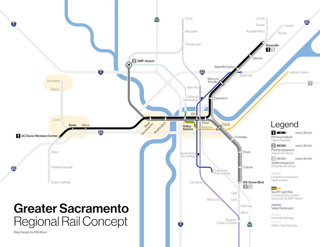
map of Greater Sacramento Regional Rail Concept, from Californians for Electric Rail

Train speed

The Sacramento region page says “Existing railroad infrastructure could support up to 125 mph top speeds” under ‘Advantages of regional rail’. The current maximum speed, set by the state based on both train equipment and track condition, is 79 mph (127 kph). But actual speeds on Capitol Corridor are often about 55 mph, reaching 79 mph only on some sections. It would require significant improvement of track quality and better trainset maintenance to accomplish faster speeds. I have heard that Capitol Corridor’s target speed is 110 mph (177 kph). The new Siemens Charger locomotives can go 125 mph (201 kph), but the still in use P42 locomotives can only go 110 mph. This isn’t to say better speeds won’t be achieved, but it is not a simple process.

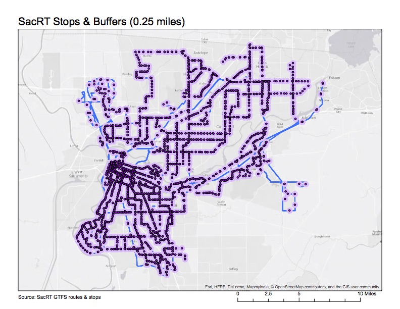
SacRT frequency and stops

Two more maps for your viewing pleasure.

The route frequency map classifies routes by their frequency of service, as 12, 15, 20, 30, or 60 minute frequency. Mostly, this means service from 6:00AM to 7:00PM, though it is shorter in a few cases and longer in several cases. Peak only routes are not shown at all. Map below and pdf SacRT_frequency.

SacRT_frequency

The other map is a different view of the routes, shown as stops with quarter mile buffers (one of the often-used walking distance to transit stop criteria, though of course some will walk further, some less, and bicycling distances are much greater. Though at this scale, the map is not significantly more interesting than the simple route map, when zoomed in, there are some very interesting patterns. I see places with stops placed closer than need be, and some places with stops placed too far apart. I’m playing with an alternate version that also shows the population density data, but not ready with that one. Map below, and pdf SacRT_stops. This is one of the first ones that I will try to put up on ArcGIS Online since it really benefits from zooming.

SacRT_stops

SacRT service changes

Sacramento Regional Transit (SacRT) has proposed service changes, primarily elimination of routes, most of which would go into effect January 2017, with a few before that and more after than. The proposal is available (summary chart after the jump), and a more detailed analysis is in the Board of Directors agenda (Item 13) for the May 23 meeting. At the May 23 board meeting, the service changes will be an informational item, not a decision. Five open houses on the service changes were scheduled, two of which have occurred, with three yet to go. I attended the open house at SacRT headquarters on May 17.

I was asked for my thoughts on the service changes. Below is a bullet summary, followed by the nerdy details.

  • SacRT should make the boardings dot map available to the public. It is the best information I’ve seen to indicate which routes are productive, and which not, more understandable to the public than the tables of numbers in the proposal. Additionally, all maps showing routes, including of course the system map, should have an indication of the service frequency, either by color or weight. The “all routes looking the same” maps that SacRT currently uses do not communicate this critical piece of information.
  • A portion of savings from elimination or combination of routes should be reinvested in other routes which could be moved from acceptable productivity to higher productivity with frequency, service hours, or routing improvements.
  • Reductions in frequency are counter-productive, usually making a route with challenges into a failing route, which will then be identified in a future round of service changes for elimination.
  • Routes serving low density residential and semi-rural areas should be cut before routes serving moderate to high density residential areas.
  • Combining routes for more efficient coverage, particularly where routes overlap or are very closely parallel, is a good idea.
  • Saturday service should be retained on all routes. Transit-dependent riders who work the usual weekday work week must have service on at last one weekend day so that they can grocery shop, visit friends and family with less mobility, and seek medical care.
  • Routes should not be eliminated for at least two years after creation or significant revision. Time is needed to see ridership trends once people in a community adjust to the service. Specifically, this means: do not eliminate Route 65 Franklin South.
  • The concept that routes should focus on light rail connections rather than radial routes to downtown, or point-to-point routes, should be considered in all route decisions.
  • SacRT should do a complete system re-visioning within the next four years. A series of cuts, and even transit renewal, has left a system that is inefficient and probably unjust. It should be redesigned from scratch.

Read More »

transit frequency in Houston and Sacramento

Houston has been in the news recently, and will certainly be today, opening day, for their revised transit system which created a network of high frequency (service every 15 minutes or better, 15 hours a day, 7 days a week) transit lines. The map below left shows this new system, only, and clicking goes to the high resolution image on the Houston METRO website. The map below right shows the entire system, with lines that don’t meet the high frequency definition. The system was redesigned with the help of Jarrett Walker, transit consultant and author of Human Transit, which I posted on yesterday and will be posting a lot more in the near future.

Houston METRO Frequent Network

Houston METRO System

So, what’s the story in Sacramento?

Read More »