All-lanes tolling means that all lanes of a freeway or bridge are tolled, or priced. Freeways and bridges are incredibly expensive to build and maintain, even if they are not way over budget as most bridges and many freeways are. Gas tax or road charge (road charge) will never be enough to pay for these infrastructure projects and maintenance. Therefore, more than half of the cost is shifted onto taxpayers who use less of these facilities, or don’t use them at all. In the future, either more and more taxpayer funds will go to keeping these facilities in state of good repair, or they will deteriorate, which is already happening in many places. The solution is to have the users of such facilities pay the full price of such facilities.
Caltrans approach to transportation is to continually build more and to under-maintain what they already have. Anyone who says the era of big, expensive bridge and freeway projects is at an end doesn’t know Caltrans. Caltrans is like the heroin addict who needs ‘just one more hit, and then I’ll quit’. The only solution is to have Caltrans go ‘cold turkey’, ceasing all freeway expansions and focusing on maintenance. Of course most Caltrans engineers would be suddenly superfluous, and that it the real issue, that freeway and bridge building is just an employment program for engineers, having little to do with meeting the needs of the traveling public.
Another reminder from Enzo. He commented on how dangerous the Watt Ave & Auburn Blvd intersection is, which led to a discussion about the entire section of Watt Ave between the Watt/I-80 light rail station and Auburn Blvd. He pointed out the absolutely ridiculous crosswalk and sidewalk at the westbound onramp to I-80 Business.
westbound I-80 Business onramp with pedestrian crossing and sidewalk
As you can see, the sidewalk leading down to, or up from, the crosswalk on the left hand side is quite steep. It would not be navigable by anyone in a wheelchair, or with any mobility limitations, and Enzo said that even an able bodied person would have difficulty with it. I only walked this sidewalk on the west side of Watt Ave once, and it was such an unpleasant experience that I never did it again. This particular issue did not stand out in my mind because the entire section was so uniformly unpleasant and dangerous.
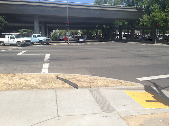
westbound I-80 Business onramp aerial
As you can see in the Google overhead view, this onramp has a long approach, so most drivers are already going 65 mph when they hit the crosswalk (the speed limit on Watt Ave is 45 mph). So anyone using this crosswalk would be likely to die. For drivers, there is no warning of the crosswalk ahead, and so no reason to take the onramp more slowly. The crosswalk is not even a high visibility crosswalk, but the outmoded two stripe version which can’t even be seen when the pavement is wet.
And very few people do use this sidewalk and this crosswalk. When I worked in the eastern suburbs, I initially took light rail and then bicycled south to Auburn Blvd, but with no bicycle facilities and high speed traffic, that got old very quickly. So then I started taking the SacRT bus Route 1. Currently, this bus route starts and ends at light rail, though it used to go further north. I wondered why so many people got on the bus westbound at the last stop on Auburn, and got off the bus eastbound at the first stop on Auburn. So I asked them, and every person said it was to avoid this section of Watt Avenue between light rail and Auburn Blvd. They said the onramps and off-ramps made it just too dangerous to walk. I wasn’t able to talk to any bicyclists, but I’m sure they would have said the same.
This is Caltrans design, and it was designed to not be usable by people walking. This was the entire design philosophy of Caltrans, to discourage walkers and bicyclists from being anywhere near a highway.
Caltrans has reformed somewhat. For example, when the Watt Ave & Hwy 50 interchange was improved in 2015, a separated walking path and bikeway was created that when under the eastbound onramp, westbound onramp, and westbound off-ramp on the east side of Watt, then along the Watt Ave overpass. In the aerial below, you can see the pathway which loops to gain the elevation from the under tunnel to the bridge height. Note, however, that there is no matching facility on the west side of Watt Ave, so a walker or bicyclist must cross to the east side at the nearest intersection, which is Folsom Blvd to the south and La Riviera Drive to the north. Though not great, it is a considerable improvement over what was there before. It did, however, solidify the status of Watt Avenue as an expressway rather than an arterial street.
Watt Ave & Hwy 50 interchange with ped/bike facility
As you can see from the photo at the beginning, and the Watt/Hwy 50 example, the only way to solve this issue is with some sort of flyover for the sidewalk, so that there is an ADA compatible gradient and no crosswalk over the ramp. I’m expecting that Caltrans will start that project in about 2121. There was a proposal by SacRT to improve the section of Watt Ave between light rail and Auburn because they recognized that the walker and bicyclist hostile nature of the corridor was reducing use of light rail. But the city and Caltrans did not seem interested.
Though Caltrans created these hazards, and the hazard is clearly on Caltrans property, the agency has shown little interest in solving the problems they created. They have washed their hands of the roadway part of interchanges by handing these over to the cities or counties. Their preference remains building new stuff rather than maintaining and correcting existing freeways and highways, and I’m not at all sure that will ever change.
Freeway on-ramps and off-ramps are designed solely for the benefit of motor vehicle drivers, with the objective being to allow drivers the maximum possible speed, both entering and exiting freeways. Drivers, whenever possible, accelerate to freeways speeds before even reaching the on-ramp, and often do not decelerate for one or two blocks after leaving the freeway. These are pedestrian killers, and they must be modified. Motor vehicles should either be required to make a 90 degree turn, or stop, before entering and exiting ramps. The ramps allow for the acceleration and deceleration necessary, that does not need to happen on the streets.
You might think that this will require approval from Caltrans, but Caltrans has washed their hands of the freeways over-crossings and under-crossings, except where the intersecting road is also a state highway. These fixes may be quite expensive, as is true of most projects that correct for previous mis-design, but they need to take place.
Policies:
All freeway on-ramps and off-ramps will be redesigned to require a complete stop and/or right-angle turn entering or exiting freeways. Pedestrian facilities will be redesigned so that pedestrians receive priority and full safety protection at all on-ramps and off-ramps. Complete within ten years.
At completion of the redesign, all pedestrian crossing prohibition at on-ramps and off-ramps, and the intersections associated with the ramps, will be removed.
Sometimes I catch a ride from a friend or take an Amtrak bus, and am on freeways in the Sacramento area, which most of the time I never see. I wonder why there are so many lanes for so few cars, so much expanse of empty concrete and expensive bridges. Of course I know the answer, the freeways have been built for two rush hours, morning and afternoon, on five days a week, perhaps 13 hours per week out of 168 hours in the week. Oh, and the Friday up to the snow or Tahoe and Sunday back home, that weekly migration of bay area people. The rest of the time they are largely empty.
Yet freeways take up a huge amount of space, have a huge carbon footprint for construction and maintenance even before fuel consumption comes into play, spew pollution into neighborhoods, and suck up the largest portion of our transportation funds. As an example of cost, the nine miles of the six-lane Capitol City Freeway (Business I-80) from Interstate 80 to Highway 50 is 54 lane-miles. Though the cost to construct a lane-mile varies widely, from $2M to $80 million, lets take a very conservative number of $5M and say that this section of freeway cost a quarter of a billion dollars. And this is not even an expensive highway, with its simple interchanges. Pretty amazing, huh? What else could we have done with that money?