disconnected bike network

A recent article on CapRadio: Sacramento’s bike network received a failing grade. City officials disagree was also reference on Streetsblog California.

The People for Bikes analysis on Sacramento is at https://cityratings.peopleforbikes.org/cities/sacramento-ca. Note that only cities are rated, not counties, so there is no rating for unincorporated Sacramento County. Sacramento’s score was 36, Rancho Cordova’s 29, Folsom 37, Elk Grove 23, West Sacramento 25, and Citrus Heights not scored.

The lead photo on CapRadio is a concrete-separated bikeway on Broadway. But it is only one block long, and is the only one in the city.

A quote from Jennifer Donlon Wyant is revealing of exactly the problem with Sacramento bike facilities:

“M Street from Sac State to Midtown through East Sacramento is known to be an all-ages and abilities bikeway connecting schools and health care and retail, and that is shown as a high-stress facility,” she noted. “When known low-stress facilities like this are showing up as high stress, that concerns me.” 

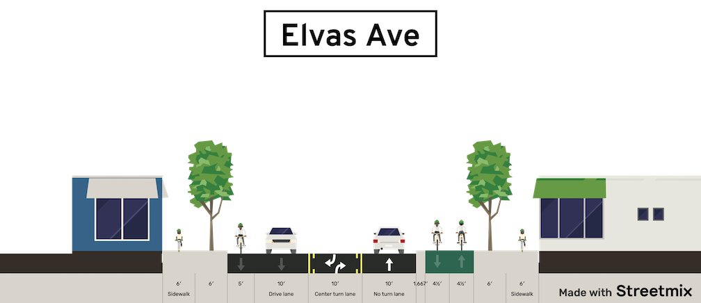
Yes, parts of M Street are great, and should be recognized with a neighborhood or greenway status. Though it is an overly wide street along much of its length, traffic is slow and light, and it meets the definition of a low-stress bikeway.

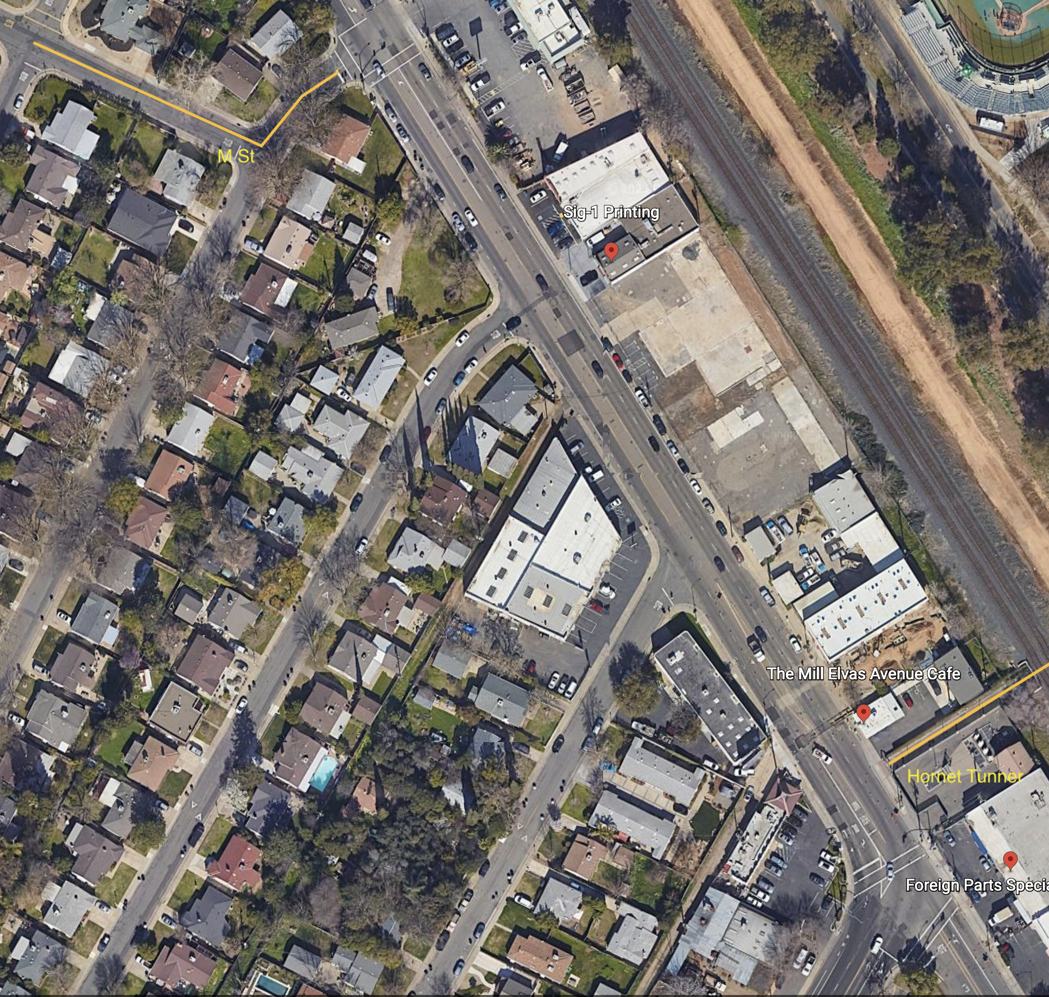
However, what happens at either end? Approaching Alhambra, M Street ends, with no bike lanes on Alhambra, and no wayfinding for how to shift to a low-stress route to continue westward. At the east end is Elvas Avenue, one of the most hazardous bike routes in the city. Bicyclists exiting onto Elvas Avenue from 62nd Street must cross four lanes of high-speed, high volume motor vehicle traffic to reach the safety of the Hornet Tunnel and SacState. Most bicyclists cross early and ride against traffic. It is slightly less hazardous to go westbound to M Street. There is no wayfinding for how to best deal with this situation.

The city has been aware of the Elvas problem for years. Nothing has been done. This blog has written about it many times: tag:Elvas-Ave.

All of the parking-protected, separated bikeways in the city are discontinuous:

  • 10th Street northbound: starts at W Street with an awkward transition from east side to west side; ends at I Street
  • 9th Street southbound: starts at I Street; ends at Q Street; design is very inconsistent with bike lane-only blocks
  • P Street westbound: starts at 21st Street; ends of 9th Street
  • Q Street eastbound: starts at 9th Street; ends at 21st Street
  • J Street eastbound: starts at 19th Street; ends at 28th Street
  • 19th Street southbound: starts at H Street; ends at W Street with an awkward transition from east side to west side; at Broadway the route transitions to Freeport Blvd with no bike facilities
  • 21st Street northbound: starts at W Street with an awkward transition from east side bike lane to west side separated bikeway; ends at H Street with a semi-protected bike signal

For few of these routes do the separated bikeways take you to a final destination. There are transitions to regular bike lanes, or no bike lanes at all, at the ends of each segment. That is not a connected network. It is disconnected!

Almost every advocate in the city is supportive of Jennifer Donlon Wyant and all she has accomplished to make the city more bikeable, more walkable, more livable. However, the city policy, by staff at a higher level, and city council, to spend almost none of its general fund on transportation safety, and to rely only on state and federal grants. means that the city will continue to rank low on any assessment of bicycle friendly.

Sacramento needs a connected network, and we are far from that.

Google map of Elvas Ave from 62nd St to Hornet Tunnel

Elvas Ave and Hornet Tunnel update

Re-upping the Elvas Ave and Hornet Tunnel post from earlier this year. It has been reported to me by a number of bicyclists, and I have experienced it myself, that this section of Elvas between the Hornet Tunnel and the signal at 62nd Street has become significantly more hazardous due to the motor vehicle traffic generated by The Line (a collection of various food vendors, opened 2022) and Garden at the Line (an outdoor eating and drinking area adjacent to The Line, opened this December). There is a lot more come and go parking on Elvas, and a lot more motor vehicle traffic in and out of the parking lots. Most bicyclists ride on the sidewalk to avoid the fast-moving traffic, otherwise the crash rate would be higher. The M Street to Elvas Avenue to Hornet Tunnel route is probably the busiest in the city.

In addition to the previous post (reblog below) about the hazards for bicyclists, this area is now hazardous for walkers along and crossing Elvas.

I was there last night for the SABA social gathering, and the place was packed. People were parking along the west side of Elvas as well as on 63rd Avenue and 64th Avenue, and then trying to cross Elvas to Garden at the Line. It was nearly impossible to cross, as there are no marked crosswalks over Elvas at either street, drivers are going fast, and Elvas is not well lit. The speed limit in this section is 40 mph, which almost guarantees that walkers hit by cars will die. Sidewalks on both sides of Elvas are in poor condition, and rolled curbs are common, which are less safe for people walking than vertical curbs. There are no sidewalk buffers. While this section of Elvas is not one of the top 5 or top 10 Vision Zero corridors, it will quickly become so. In the last five years, there have been two injury crashes on this stretch, one bicyclist and one walker, both in the vicinity of Hornet Tunnel.

The city has no plans to improve safety for bicyclists or walkers on this stretch of Elvas.

Folsom Blvd alternative

The city has proposed a Folsom Blvd Safety Project.  See previous post on that project. I would like to present an alternative to the bicycle facilities aspect of this project, improvement of the M Street corridor. M Street, and related streets including Elvas Ave, provide an alternative route. This route is already used by hundreds of bicyclists per day, students at Sacramento State, other commuters, and recreational bicyclists accessing the American River Parkway. Folsom, on the other hand, sees very little bicycle use. This is because it feels dangerous for most bicyclists, and because it is not the most direct route for many destinations.

The lack of bicyclists does not indicate that the street does not deserve bicycle facilities. Folsom has no bicycle facilities in the section to be revised, does not feel safe for bicyclists, and is not safe for bicyclists. The classic saying is that you can’t judge the need for a bridge by the number of people swimming the river. Bicyclists deserve safety on every street.

However, since bicycle facilities are a primary feature of the project, so it is worth asking: ‘Is this the best investment of limited funds?’ I’d suggest that upgrades to the M Street corridor might be a better investment.

Neither route actually offers safe access to and through Sacramento State. M Street is a low volume, mostly low speed street, from Alhambra Blvd to Elvas Blvd, However, the section along Elvas to the Hornet Tunnel that goes under the railroad tracks, is hazardous and intimidating for bicyclists. Folsom Blvd, with this project, would provide basic bicyclist facilities from Alhambra to 65th Street. However, access to and through Sacramento State beyond 65th Street is poor. The ‘safer’ crossing of Folsom at 69th Street and Elvas Avenue is awkward, was designed for walkers and not bicyclists, and not really safe. I have observed a number of drivers blowing the red light at this crossing. After crossing Folsom, a bicyclist can jog west to Elvas Avenue, and ride that to Hornet Tunnel, though the street is very deteriorated, of widely variable width, and the entrance to the tunnel is awkward.

The map below shows both routes, M Street from Alhambra Blvd to Elvas Avenue, in orange, and Folsom Blvd from Alhambra Blvd to 65th Street. Both are of equal length. Folsom Blvd has bike lanes from Alhambra to 47th Street, and discontinuously from 49th Street to 57th Street, with nothing to the east. M Street does not have bike lanes, but is is a low volume, low speed roadway along which most bicyclists feel comfortable riding. It is a ‘low stress bikeway’. Some of the route is marked with bike sharrows. Though improvements could certainly be made to M Street, it is functional as is, as a bicycle route.

Folsom Blvd has a posted speed limit of 35 mph, and much higher speeds are routinely observed. The fatal crash was in fact due in part to egregious speed violation by a driver. The proposed project would reduce speeds somewhat due to prudent drivers, but will probably encourage passing in the center turn lane. The project would leave the posted speed limit unchanged. M Street has a posted speed limit of 25 mph throughout, and speeds above 30 mph are rare. Would bicyclists rather ride on a non-bicyclist facilities roadway with 30 mph traffic, or on a buffered and un-buffered bike lane with 50 mph traffic?

Both of these routes are unacceptable because they don’t create a safe corridor all the way to Sacramento State. However, I feel that an investment in improving the M Street corridor section along Elvas would be a better investment than bicycle facilities along Folsom Blvd which end at 65th Street.

I wrote about improving the section of the M Street corridor between 62nd Street and Hornet Tunnel earlier this year: Elvas Ave and Hornet Tunnel. I don’t have a cost estimate for this project.

I am not saying the the Folsom Blvd Safety Project is a bad idea, just raising the question of where funds can be best invested to improve safety and comfort for bicyclists.

Folsom Blvd safety improvements

I said in my post about the Sacramento Active Transportation Commission meeting of May 16, and in an eComment, that I was generally in support of the Folsom Boulevard Safety Improvements Project, agenda item 3. I am still in support of the project, but conversations with a number of people since them have pointed out weaknesses in the project that I will comment on.

  • Speed limit: The city does not propose to reduce the posted speed limit on the revised sections of roadway. The posted speed limit is 35 mph, and of course the design speed and typical speed is much higher. The reduction of general purpose (motor vehicle) lanes from four to two will result in lower speeds under some conditions, where a prudent driver sets the pace, but where there isn’t a prudent driver, other drivers will continue to travel well over the speed limit, creating the threat of traffic violence for all roadway users. Though not common, some drivers will use the center turn lane to pass slower drivers, increasing the danger for everyone. The city must reduce actual speeds with a safer design that enforces the desired speed.
  • Gutter pan bike lane: For several segments, the project proposes to keep the existing wide gutter pans and use them as part of the bike lane. This is probably illegal under state law, but even if not, it is poor practice. The gutter pans are acceptable in some locations, but in many cases are quite deteriorated and not rideable. Either the gutter pan must not be counted as part of the bike lane, or it must be replaced.
  • Lane widths: The projects indicates lane widths of 11 feet for the center turn lane and the two general purpose (motor vehicle) lanes, or 33 feet of the available roadway width. This is unnecessarily wide and will encourage drivers to travel at a higher speed than is safe. It is worth remembering that the fatality which initiated this project was due in part of excessive speed.
  • Bike lane design: The bike lanes are indicated as five feet. This is the minimum required by law, but is insufficient. It does not allow for safe passing of one bicyclist by another, and limits use by wider bicycles such as cargo bikes and three-wheeled bikes. The bike lane buffer is as narrow as 1.2 feet in some segments. This does not provide any real sense of security for less confident bicyclists. In some sections, the bicycle buffer has vertical delineators (shown as K-71 green delineators), but in other sections has no delineators. The narrow buffers and lack of delineators will not encourage bicyclists to use Folsom Blvd as a travel route. It might be better to improve bicycle facilities on M Street and Elvas Avenue, which is a parallel route commonly used by bicyclists, students and others, from east Sacramento to Sacramento State via the Hornet Tunnel.
  • Sidewalks: At no location in this entire project are sidewalk improvements shown. The sidewalks, where present, meet minimum standards, but do not have sidewalk buffers (planting strips), and there are several short sections with no sidewalk at all. Sidewalks without sidewalk buffers do not encourage people to walk. This is yet another city project with claimed safety benefits in which sidewalks are ignored as though they are not a critically important part of the transportation network. New ADA-compliant curb ramps are indicated in a few locations, but safer crossings are irrelevant if travel along the corridor is discouraged.
  • Slip lanes: The slip lane for 51st Street southbound at Folsom is retained. The small pedestrian island between the two travel lanes is not comfortable for walkers. The project also retains slip lanes for Folsom Blvd eastbound to 65th Street south, and 65th Street eastbound to Folsom Blvd east. Slip lanes are hazardous for all roadway users, and should be removed whenever a street in reconfigured.
  • Center turn lane: As with almost every project the city has proposed, there is a center turn lane along the entire length. I consider these to be a waste of roadway space except where the frequency of turning movements, to or from the major roadway, justify a center turn lane. Otherwise, they are just empty, seldom used space that could be better allocated to other uses.
  • Driveway closures: Driveways are the single feature that creates the most difficulty for people rolliing, and people walking. Commercial properties should be limited to one driveway in/out, of 20 feet, or two driveways, one in, one out, or 20 feet each. Twenty feet is required for commercial driveways by fire regulations. Where driveways are available on side streets for commercial properties, they should be used and driveways on the main roadway closed or greatly narrowed.
  • 48th Street flared intersection: The intersection of 48th Street to the south has a flared design, with extremely wide turning radii, leading to a crossing distance curb to curb of 140 feet! This is a crossing that intimidates walkers, yet the project makes no effort to correct this, or even acknowledge it.

In summary, this project presented as a safety improvement project has major weaknesses that reduce its effectiveness for safety. Remember that the fatality was on a sidewalk, and the result in part of a speeding driver. It was not a bicyclist. Of course I am in favor of higher quality and safer bicyclist facilities, but it seems to be the view of the city that if things are improved for bicyclists, walkers can be ignored. I strongly disagree.

This is another city project that could be transformative, but falls short. The city is unwilling to make our streets significantly safer by prioritizing walkers over others. The General Plan has this diagram. Worth repeating again and again, until the city finally takes it seriously.

I have to admit that I missed a number of these issues when I quickly scanned the project document. If readers see additional issues that I have missed, please comment.

The cross-sections below are from the project document. Each is option two, which has more visual separation of bicyclists from motor vehicles by using buffers and/or vertical delineators. Option one does not provide any separation. But the buffers reduce the bike lane widths to five feet. Whether narrower bike lanes with visual protection, or wider bike lanes with no separation except a white stipe, are better, is a question I do not have a clear answer for. But modern bikeway designs provide both visual, or actual, protection, and wider bike lanes. These bicycle facilities are the minimum acceptable.

Folsom Blvd cross-section, 47th to 53rd, option 2
Folsom Blvd cross-section, 53rd to 63rd, option 2
Folsom Blvd cross-section, 63rd to 65th, option 2

Elvas Ave and Hornet Tunnel

The section of Elvas Avenue between 62nd Street and Hornet Tunnel which leads to Sac State is very dangerous for bicyclists. Bicyclists have to transition across four lanes of traffic (three travel lanes and a center turn lane), without any protection whatsoever. The pavement quality is low, particularly on the east side where the ‘bike lane’ (not a real bike lane) is. Despite this, it is a high-use bicycle route from Sacramento to Sac State and the American River Parkway trail. M Street, this section of Elvas, and the Hornet Tunnel serve as a bicycle boulevard (though not designated) between the central city, Sac State, and beyond.

Since the day I arrived in Sacramento and rode my bike to work in the eastern suburbs, I have known that this section needs to be fixed. It took me 12 years to get around to writing about it. I hope that it will take the city less to fix it. The solution presented here is not the only solution, so I encourage others to comment, point out flaws, and suggest optimal solutions.

Elvas Avenue is a high-speed, moderately high-volume roadway that acts in many ways as an expressway due primarily to the turns from Elvas Avenue to 65th Street, and from 65th Street to Elvas that encourage high speeds. The roadway is dangerous for motor vehicle drivers and passengers as well as bicyclists. North of 62nd Street, St. Francis High School (about 1100 students) suffers from traffic risk created by Elvas Avenue, so traffic calming to the south will benefit the high school as well as bicyclists. It might be appropriate to extend the separated bikeway north to the signalized crosswalk over Elvas to the school.

Read More »

M Street to Hornet Tunnel

I have long been planning to write about the extremely poor bicyclist facilities from M Street to Hornet Tunnel, which is a major access point for Sac State.

M Street is a major east-west bicycle route, with some but not all of it marked as a bicycle route. If the city used the bicycle boulevard designation, it would be designated a bicycle boulevard. M Street forms an uncontrolled T-intersection with 62nd Street, which leads a short way left to a signalized T-intersection with Elvas Ave.

Hornet Tunnel is a major access point to Sac State campus, probably second only to the Guy West bridge access on the north side.

The map below shows M Street, 62nd Street, Elvas Ave, and Hornet Tunnel, as it exists.

The route from M Street to Hornet Tunnel is heavily used by bicyclists, both students and people passing through to the American River Parkway paths. It would be much more heavily used if it were safe, but it is not.

Eastbound to campus, one must cross over four lanes somewhere between 62nd Street and the median along Elvas Ave, and then ride on the wrong side of the street to reach Hornet Tunnel. Westbound, it is not bad, only having to merge over the northbound lanes to a dedicated left turn lane to 62nd Street. The signal here is surprisingly responsive to bicyclists, so the wait is usually short.

At the 62nd Street & Elvas Ave intersection, Elvas is 62 feet wide, 70 feet with sidewalks. There are shoulder stripes setting off unofficial parking, one southbound lane, one center turn lane, and two northbound lanes. At 64th Ave, Elvas is 68 feet wide, 76 feet with sideewalks. At Hornet Tunnel, Elvas is 63 feet wide, 77 feet with sidewalks, with two northbound lanes and three southbound lanes, two of which are dedicated right turn lanes to 65th Street. Elvas was formerly wider at Hornet Tunnel, but some sidewalk was added there to ease crowding at the tunnel entrance/exit. Given the city-preferred, though unnecessarily wide 11 foot travel lanes, there is room for six lanes of traffic here! That means there is ample room for bicycle facilities. But there are none present.

Some bicyclists take the striped shoulders to be bike lanes, but they are not. The city’s 2018 Bikeway Master Plan shows this section of Elvas between 65th Street and Hornet Tunnel as a Class 2 (on-street) bike lane, but this is false. It is not indicated as such with either pavement markings or signage. Though the shoulder stripe southbound has the dashed marking often used to indicate a bike lane approaching an intersection, this is a fake. It is NOT a bike lane. People park along this stretch, so even if it were a bike lane, it would not be safe nor meet minimal standards for a bike lane.

Solutions

What street redesign and reallocation would make is safer for bicyclists?

First, for northbound bicyclists, there should be a separated bikeway on the right side of the street. Along this section, there are four driveways and a stretch of street-oriented perpendicular parking (where vehicles enter directly into parking spaces from the street). There is a section of 270 feet with no existing buildings. Though there could be parking protected bikeway along here, I don’t think the parking is even needed. Instead, this is probably a good location for a curb separated bikeway, with hard curb to prevent encroachment on bicyclists. The curb would be cut only for driveways which are currently in use. The existing parking along this stretch is used mostly by students to avoid paying on-campus parking fees. All the businesses have onsite parking. The one business that might reasonably need short-term parking on Elvas is The Mill coffee shop. Separated bikeways work best with long stretches without driveways, but one here is workable.

Southbound is more complicated. If there were a bike lane or separated bikeway on the southbound side of Elvas, bicyclists would still need to cross to Hornet Tunnel, at a location where there is currently no way to do so. I see three options:

  1. First, have bicyclists ride south to the existing 65th Street & Elvas Ave intersection, and use the crosswalk on the north side to cross over and then go north to the tunnel. This is very awkward, out of the way, and encourages bicyclists to use a crosswalk, which is not illegal but poor practice.
  2. Second is to create a two-way separated bikeway (often called a cycletrack) on the east side of Elvas, from 62nd Street to the tunnel. A separate bicyclist signal phase would need to be created for northbound bicyclists to cross to 62nd Street, and southbound bicyclists to cross to the east side of Elvas Ave. An advantage to this solution is that parking on the west side of Elvas does not need to be changed, though it can be reasonably argued that there should be at least a regular bike lane here for bicyclists who are not going to the tunnel, but continuing south on Elvas or south on 65th Street.
  3. Third, have bicyclists continue southbound on Elvas, but create a clear zone for crossing to the tunnel by signalization. Northbound motor vehicles would be held by the existing signal at the intersection of 65th Street and Elvas Ave, while southbound motor vehicles would be held at a stop line just north of the tunnel by new signal heads. Bicyclists would cross to the tunnel during the red phase. There would need to be queuing area for southbound bicyclists, since they would exceed the stacking capacity of the bike lane during busy times. This option probably slows motor vehicle throughput more than the other options.

No matter which solution, the sidewalks along Elvas Ave should be repaired and widened, and street trees should be planted. And of course the street needs to be repaved.

Below is a Streetsmix diagram showing one possible configuration (looking north) with a two-way separated bikeway (cycletrack) on the east side, along with wider sidewalks and trees in a planing strip, and a southbound regular bike lane. And yes, all this fits in the existing over-wide Elvas Ave right-of-way!