For other posts on the H Street Bikeway project, see category: H Street Bikeway. For the city webpage on the project, see H Street Bikeway to Sacramento Valley Station.
Update: Edited to add more accurate segments and cross-sections, make additional comments on design, make clear that the 6th-7th cross-section should be similar to the 5th-6th cross-section, with light rail tracks in their own right-of-way rather than the southern one (Line 1) being in a shared or mixed use lane with private motor vehicles.
Note: I realized last night in thinking about H Street that I had accepted too much of the city’s compromise to prioritize motor vehicle traffic and preserve parking. This section of H Street could be a model for how to do streets right, but the 30% design presented is not that. I’ve changed some recommendations and reorganized the post content.
Key points:
- Mixed use transit lanes prioritize motor vehicle traffic over transit safety and efficiency. The mixed use lane between 6th Street and 7th Street must be changed to a dedicated transit lane.
- The two-way bikeway must be a minimum of 10 feet in width (5 feet each direction) in order to provide safety, usability, and maintainability. This will require changing parking and/or general purpose lanes widths.
- Two-way bikeways must have bicycle signals at every intersection. This design does not.
- Where there are two general purpose travel lanes in same direction, as between 9th Street and 10th Street, only one lane needs to be 11 feet, while the other must not be more than 10 feet. This is generous, as most modern recommendations are between 9 and 10 feet. The safety advantages of narrower lanes are well documented.
- Maintenance of on-street parking is clearly a priority in this design. While on-street parking can slow traffic, and is appropriate in retail and residential areas, here it is for the convenience of workers who could park in the ample parking garages and lots along and near H Street. Where roadway width is needed for safe and high quality bikeways, on-street parking can and should be removed.
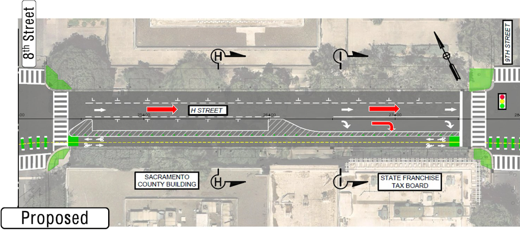
The H Street Bikeway to Sacramento Valley Station project is presenting at the SacATC meeting this week, Thursday, February 19, starting at 5:30 PM. A community workshop will be held Thursday, February 26, starting at 5:30 PM at city hall, room 1119. This project is part of a large grant-funded project (TIRCP – Transit and Intercity Rail Capital Program) to improve Sacramento Valley Station. H Street is the main access route from the station for bicyclists. There are no safe routes to the station, at this time.
The project will create a two-way separated bikeway (also called a cycle-track) on H Street between 5th Street (the station) and 10th Street and 9th Street with existing bicycle facilities.
For the segment images, I have used the SacATC presentation. For the segment cross-sections, I have used the diagrams from the SacATC staff report, as they include measurements, which are critical for determining the safety and usability of the bikeway. StreetMix diagrams usually include measurements, but the ones in the presentation do not.
Transit priority
The TIRCP grant of which this project is a small part, is intended to support transit use to and from Sacramento Valley Station, to ensure that the station is the effective transit and rail hub that the city, region, and state want.
I support the double-tracking of light rail in the segment between 5th Street and 7th Street. Single-track light rail segments create pinch points where one train may need to wait for another, slowing the entire light rail system. The diagrams also seem to indicate a crossover between 5th Street and 6th Street, which is valuable for routing trains when there are blockages.
Segments
Bicycle facilities within Sacramento Valley Station, west of 5th Street, are not part of this project. I have not seen any recent information on how bicyclist circulation will be handled within the station area.
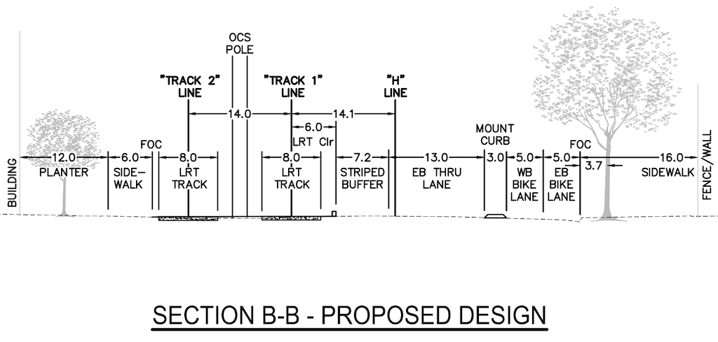
5th Street to 6th Street
This segment is reasonably well designed but could be improved. Double-tracking of light rail removes a bottleneck for the Gold Line/Green Line.
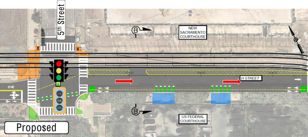
The buffer between light rail and general purpose lane (7.2 feet), and the overly wide general purpose lane (13 feet), totaling 20.2 feet, waste roadway width that could be devoted to the two-way bikeway. A better allocation would be, from right to left, 12 foot bikeway, 3 foot mountable curb, 3 foot buffer, 11.2 feet general purpose lane, and 4 foot buffer.
6th Street to 7th Street
The segment shows a light rail track sharing with motor vehicle traffic. This is inappropriate, and removes the advantage of double-tracking, since trains can be stuck in congested motor vehicle traffic. The southern or right hand lane should be a combined through and right turn lane, and the northern or left hand lane should be eliminated. The design constrains the bikeway to 4.5/4.75 feet, rather than the minimum of 10 feet. Diagrams below.
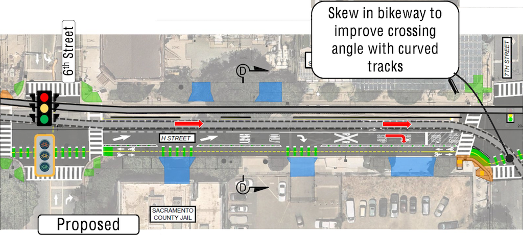
The 6th Street to 7th Street cross-section should be designed similarly to the 5th Street to 6th Street cross-section, shown below, with the suggested modifications to roadway allocation, as above in 5th Street to 6th Street segment.

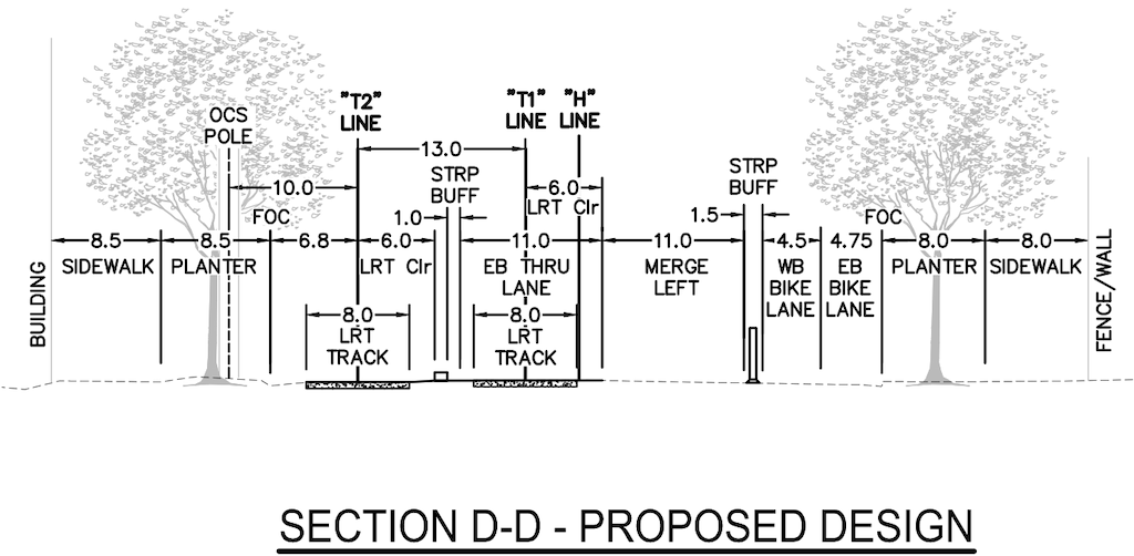
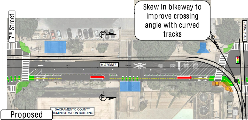
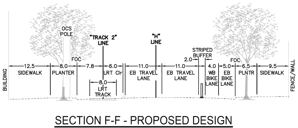
7th Street to 8th Street
The preservation of parking in this segment is ridiculous. There is a parking garage of large capacity directly north across the street, so there is no reason for on-street parking here. The city’s desire to maintain parking in this section is in fact the reason why the existing Class III (sharrows only) bike facilitiy on H Street is dangerous and unpleasant. Again, retention of parking constrains the bikeway to 4.0/5.0 feet rather than the minimum 10 feet. Diagrams below.
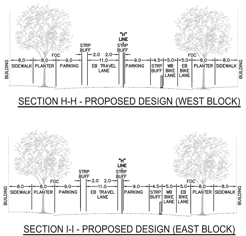
8th Street to 9th Street
The segment design is reasonable.
However, since there are no driveways in this block, the separation between motor vehicles and bikeway should be a hard concrete curb, not a stripped buffer. The 10 foot bikeway is the minimum width, however, narrowing the parking lanes to 8 feet would provide space for a desired 12 foot bikeway.
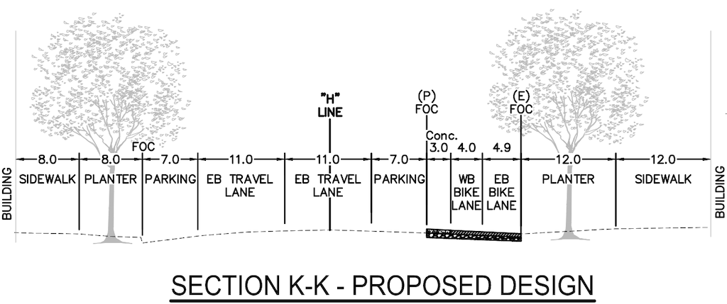
9th Street to 10th Street
I like the design of the segment, a sidewalk level completely separated bikeway.
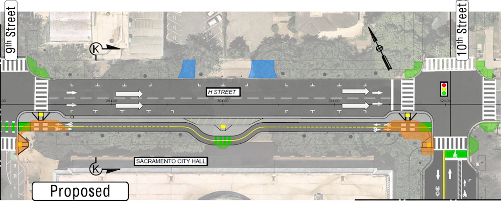
The width of the bikeway is 4.0/4.9 feet (8.9 feet) rather than the minimum of 10 feet. It is not clear how to reallocate roadway width to accomplish this, but it must be done.
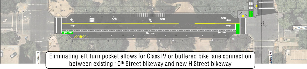
10th Street from I Street to H Street
This segment design is reasonable, given the curb extensions (bulb-outs) present at the bounding intersections. This project probably does not have the funding to reconstruct the street to create a separated bikeway, though this should be done in the long term. A separated bikeway would complete a buffered or separated bikeway on 10th Street all the way from Broadway to H Street. Despite the call-out on the image below, this is just a buffered bike lane, not a Class IV (separated) bikeway. Parking is not needed on both sides, as ample parking is available on nearby streets and in the city parking garage on the southeast corner of I Street and 10th Street.
Signals
The staff report diagrams use the phrase ‘Traffic Signal (Eastbound/Westbound) to be Modified or Replaced’. I am very concerned with ‘replaced’. The city has a penchant for replacing signals, and controller boxes, that do not need to be replaced, raising the cost of projects or wasting money that could be better spent on other parts of the project.
The presentation diagrams show bicycle signal faces at 5th Street and 6th Street, but not 7th Street, 8th Street or 9th Street. Bicycle signals are necessary at every intersection for the safe operation of two-way separated bikeways. It is possible they were neglected on the diagrams, but they cannot be neglected in the project.
Signal timing should be set to a ‘green wave’ of about 13 mph, to allow bicyclists continuous movement through the five blocks. If signal timing remains the same, bicyclists will encounter red light at every intersection, making the bikeway much less useful.
Every pedestrian signal in this section should include a leading pedestrian interval (LPI). Though valuable to enhance transit and bicycling, the design must not disadvantage people walking along or across the corridor.
Speed
The posted speed limit in this section is 25 mph, but observed speeds are higher. This section seems to serve, since the conversion of 5th Street to two-way traffic, as a cut-through from 5th Street to 16th Street, and the design of the intersection of H Street at 16th Street, three dedicated left turn lanes, supports this use. The speed should be reduced to 20 mph, in part to reduce the differential between motor vehicles and bicyclists. Though the bikeway separates these two uses, bicyclists will need to use the general purpose lanes at some points to enter and exit the bikeway, reaching other destinations in addition to the end points. If the posted speed remains 25 mph, and the actual speeds higher, drivers will be encouraged to speed in order to hit green lights. In the central city, many signals are set to 28 mph, encouraging drivers to speed.
Bikeway design
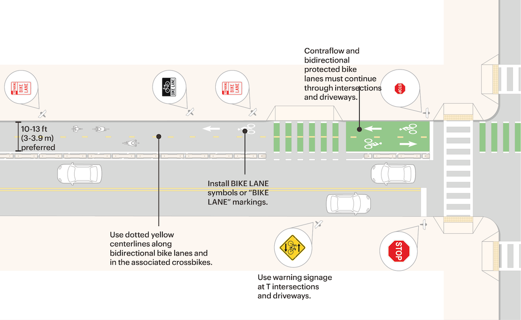
The width of the two-way bikeway in this five block section varies from 8.9 feet (4.0 + 4.9) to 10 feet (5 + 5). The smaller width is not enough to provide safe passage for two larger bikes, such as three-wheel bikes, cargo bikes, and bikes with trailers going in opposite or the same direction. The minimum width throughout must be 10 feet. NACTO’s Urban Bikeway Design Guide says: Two-way bike lanes should be at least 13 ft (3.9m) wide to accommodate all types of bicycles, side-by-side riding, platooning, and passing. A consistent width also allows for bikeway sweeping by devices which cover the full width of the bikeway. The City of Sacramento is deficient is maintaining its existing separated bikeways free of leaves and trash, so future bikeways must be designed for ease of maintenance.
Bikeways should be designed for maximum protection against errant motor vehicles. In blocks without driveways, a concrete curb should be installed, with small gaps for bicyclists to enter and exit. The segment between 8th Street and 9th Street is one such segment. The design with a buffer from parked cars is only effective when parked cars are present. A dedicated motor vehicle right turn lane is adjacent to the bikeway with only a very narrow buffer. The segment from 9th Street to 10th Street seems to have this protection by design. Mountable curbs, as shown for 5th Street to 6th Street may also be appropriate for parts of the 6th Street to 7th Street and 7th Street to 8th Street segments.
NACTO Urban Bikeway Design Guide
The page on ‘Designing Protected Bike Lanes‘ provide guidance on three situations, including two-way (bi-directional) bikeways. The diagram below is from that page. The page includes guidance on dimensions, marking, signs, and intersections.