The SacRT Safe Routes to Transit (SRTT) Plan held its first workshop on February 24 in Rancho Cordova. I attended the Rancho Cordova workshop, not because I live in that area, but because it was the only one that worked for my schedule. There is a virtual workshop on March 4, 5:30 PM to 7:00 PM (registration), and three in-person workshops on March 5, 10, and 11.
I was the only member of the public at the workshop in Rancho Cordova. That is sad.
The workshop had some display boards, two showing bus and light rail stops in two areas, captured below.
What the workshop, and the program, was soliciting was input on specific stops. What was not solicited was policy ideas, but I provided them anyway.
The most important policy for SacRT to implement is that all bus stops located on arterial roadways (which is most though not all bus routes) must have safe crossings of the roadway located very near the stop. Stops away from safe crossings encourage riders to cross mid-block (which is not illegal, but is not safe), or require them to walk distances to a safe crossing. I suggest that every bus stop be evaluated, and changes made. Either a safe crossing would be provided, or the bus stop removed. There are many locations where no safe crossing exists anywhere close to the stop. Implementation of safe crossings would require cooperation between SacRT and the local government (cities and county). There should be a deadline for identifying a solution, and implementing the solution. I’d suggest two years, and five years.
Though not common in the cities, there are legacy bus stops in the county that do not have sidewalk access, at all. Those stops must either be provided with new sidewalks, or be removed. Again, there should be a deadline. I’d suggest five years.
I asked if SacRT had talked to riders on the bus to gather information for this project. The answer was no. Apparently this was done in the past, but not recently, and not specifically about this issue. Advocacy organizations have surveyed bus riders on the bus, but not on this specific issue.
The two light rail stations about which I have safety concerns are Swanson and Watt/I-80 West. Not because of access, but because they are so seldom used that a rider might well be the only transit user there at the time. That doesn’t feel safe. There is safety in numbers! I question whether these two stations should be kept open.
Bus stop amenities are critical for encouraging people to ride, but are not necessarily safety issues. Every stop should have a place to sit. Most stops should have a shelter and trash can. Some stops should have bike racks and live arrival displays. Many stops do not have enough space for a a wheelchair user to wait safely for ramp deployment. This must be fixed. Placing amenities often requires a bus stop pad wider than the sidewalk (sidewalks throughout the county are often narrower than desired). Sometimes the pad will fit within the public right-of-way, but often it requires either purchase or an easement on private property. The government agency should be responsible for the arrangements, and placing the concrete pad, not SacRT. SacRT would then place amenities.
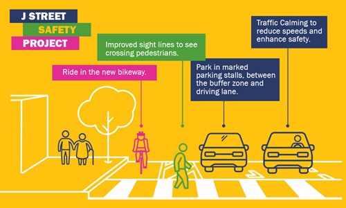 The City of Sacramento is going to use street rehabilitation funds (from SB-1) to create a separated bikeway on J Street between 19th and 30th, starting this summer. The city held a public meeting last night (January 25) to gather public comments on the design elements, which have not been finalized.
 I would like to recommend some improvements to the project as presented: