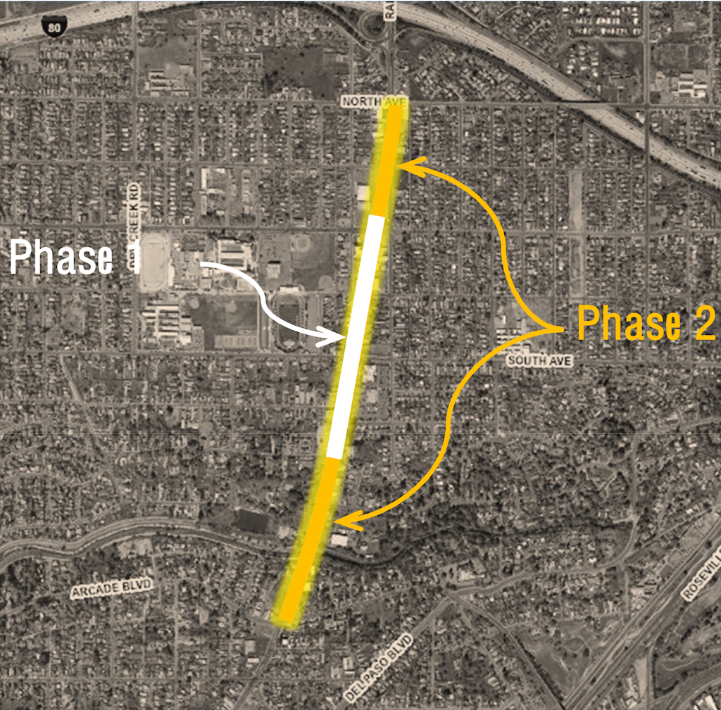
The Marysville Blvd Vision Zero Safety Project, Quick Build Phase 1, started today, Monday, March 16. The overview from the SacATC presentation on September 18, 2025, shows Phase 1, which is from Grand Avenue to Nogales Avenue only. Phase 2 will cover from North Avenue to Arcade Blvd. Phase 2 will include more extensive work, but is not being called a ‘complete streets’ project. Only Phase 1 is fully funded. The city has in the past applied for grants to convert the entire stretch of Marysville Blvd into a complete street, but has been unsuccessful in that effort, which has led to this quick build project in order to improve safety now rather than someday. Phase 1 will cost $1.4M and be completed in 2026. Phase 2 is about $18M and only partially funded.
Marysville Blvd Phase 1 and Phase 2
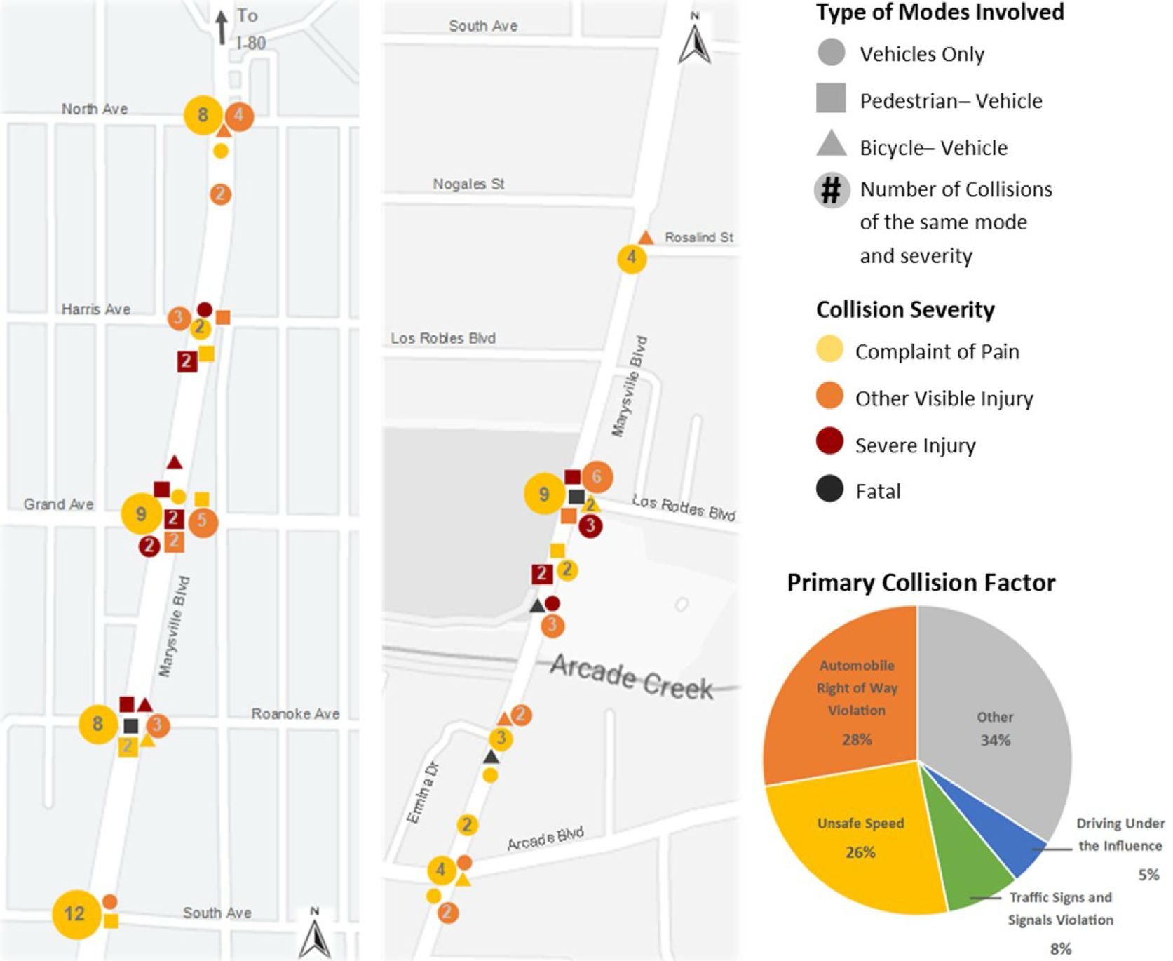
A diagram from the SacATC presentation September 18, 2025, shows collision history for the segment. This is the issue that the city if trying to solve. The diagram is rather dense with information, but of note is that of the four fatalities, three are outside the current phase, and only one is inside, at Roanoke Aveue.
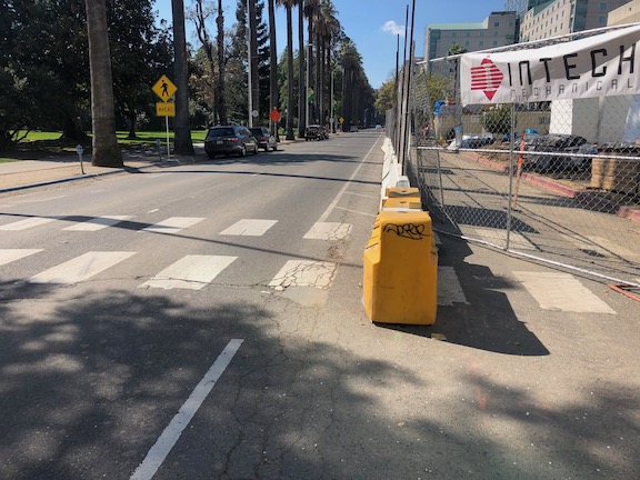
Marysville Blvd is narrowed for construction to one lane, starting just south of Harris Avenue and continuing to south of Roanoke Avenue. During my time of observation, I did not observe any significant backup of traffic, however, it was mid-day, not commute hours.
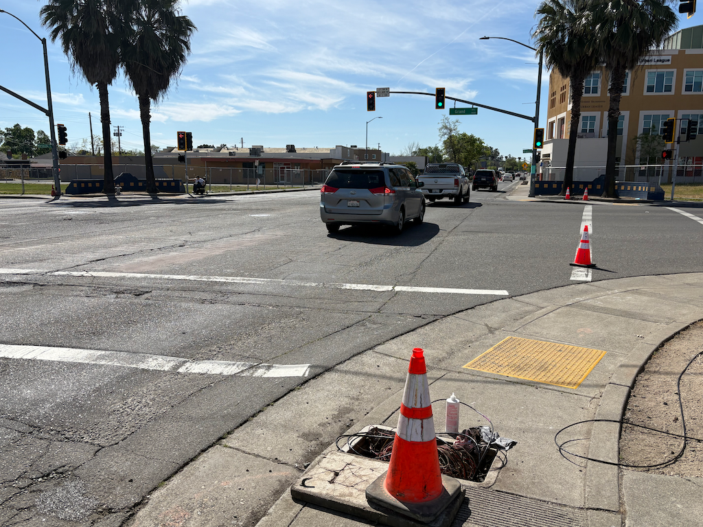
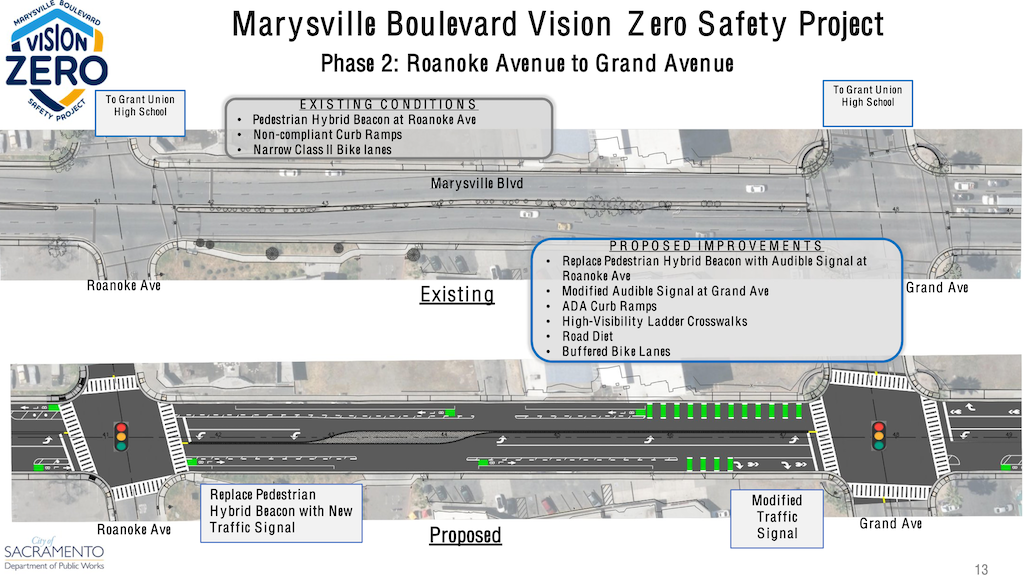
The work on this day is focused on the intersection of Marysville Blvd and Grand Avenue. Signal wiring at the intersection has been exposed and torn up, in preparation for installing a modified signal at this intersection. The diagram from the SacATC presentation on September 18, 2025 (below), shows a modified signal at Marysville and Grand. It is hard to reconcile the signal wiring being torn out with the term ‘modified signal’, but no other information is available.
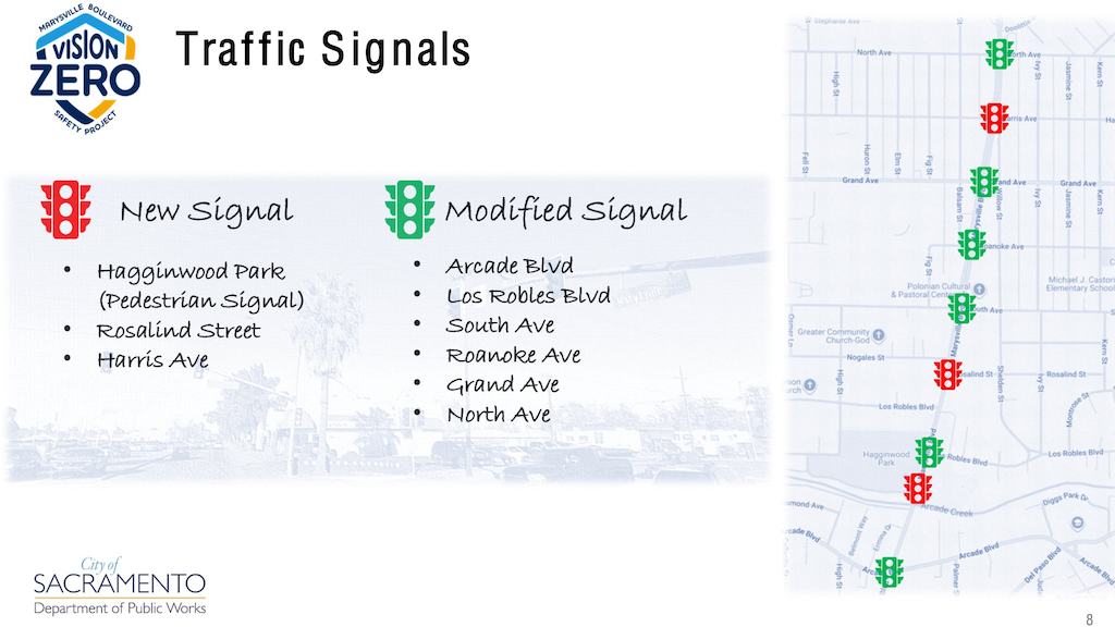
Marysville at Grand Ave, construction and signal upgradeMarysville Blvd new and modified traffic signals
The SacATC presentation on September 18, 2025, includes existing and new for the section from Roanoke Avenue to Grand Avenue, and shows a complete rebuild of the intersection, but this is Phase 2, and it isn’t clear what the intersection and signal will look like at the end of Phase 1. Though the wording is not clear, the pedestrian hybrid signal (HAWK) at Roanoke Avenue may be completely replaced with a new regular traffic signal, but again, in Phase 2. I will have another post on Phase 2, but this one is focused on the Phase 1 Quick Build.
Future post will follow the construction project, and look more closely at Phase 2.
So far as I can determine from the presentation diagrams and the plan diagrams, no sidewalk improvements other than ADA ramps at intersections are planned. Though there are sidewalks nearly throughout the segment, they are narrow and unbuffered. The majority of the driveways ramps are sloped, many to such as degree that they present a barrier to wheelchair travel.
Sadly, most of this segment of Marysville Blvd is characterized by closed businesses, long abandoned buildings, and empty lots. This is not to denigrate the existing businesses, health services, and parks, but it will take much more than this project to energize this corridor. This is an area that has been disinvested by the City of Sacramento since it became part of the city, and it shows. A Marysville and Del Paso ‘Forward Together’ Action Plan lays out some of the actions necessary to heal this community.
The City of Sacramento is holding a community workshop on Wednesday, April 23, 2025 on the Fruitridge Road Improvement Project. The in-person location will be Earl Warren Elementary School, 5420 Lowell Street, Sacramento, from 6:00 PM to 7:30 PM. There are not online options at this time for this phase of the project.
From the city email:
After the workshop held in August 2023 at Earl Warren Elementary School, the Fruitridge Road Improvements team has been updating the design plans based on community feedback while considering enhancements between Stockton Boulevard and the 65th Street Expressway.
Phase 1 runs from the 65th Street Expressway to Power Inn Road
Phase 2 runs from Stockton Boulevard to the 65th Street Expressway
About Project: The City of Sacramento is upgrading Fruitridge Road between 65th Street and Power Inn Road to enhance safety for all travelers. The project will add continuous bike lanes, fix pavement, upgrade signals, and create ADA-compliant curb ramps. Due to space limitations on the current four-lane road with intermittent bike lanes, the team is considering lane reductions to better accommodate bicyclists, improve pedestrian crossings, and enhance transit access while connecting to existing and future bikeways.
I am getting so, so tired of people on Twitter, bicycling advocates, who see bikes and bikes only as the solution to everything.
These are people who believe that it is always best to remove on-street parking in favor of bike lanes, whether regular or separated bikeways. In fact, they are always looking for roads on which to install bike facilities and remove parking, because they get off on the idea of removing all parking. A lot of advocates want bike lanes on every street.
Well, I disagree.
If there is a situation where existing or future bicycling use should be accommodated, and the only way of doing do it is to remove parking, then I’m in agreement. But that is often not the case. On any street with more than two lanes, it is almost always better to remove a travel lane (called general purpose lanes) than to remove parking.
Parking does (at least) two things:
Calms traffic by creating perceived friction, which slows drivers down. It is moving vehicles, quite often moving well over the posted speed limit, that are a hazard to bicyclists, and everyone else. It is not parked cars (not ignoring the issue of door-zone bike lanes).
Provides places for customers to park who so far have not shifted to walking and bicycling, or who are in that rare situation of needing a car for disability reasons or items being picked up/dropped off.
Sure, we need less parking than we have, but no parking is not the solution. If there is no on-street parking, then it increases the demand for surface parking lots, which are the worst possible land use in cities, or for structured parking (parking decks) which are the most expensive type of parking to build, and almost always require taxpayer subsidy. Both of these also produce almost zero property tax and sales tax.
I’m also in favor of managed parking, so that it is never free, and costs enough so that there will always be some empty spaces available, and that drivers are paying market value for parking, and for the cost of the pavement and maintenance they are using. I’m also in favor of designated passenger drop-off/pick-up curbs and unloading/loading curbs for commercial use. We do have too much parking, and way too much free parking. We should have less.
For those who I haven’t convinced, or have made angry (no doubt), please read The High Cost of Free Parking by Donald Shoup, and Walkable City by Jeff Speck. Both recommend retaining parking, but managing it better, in most situations. And removing it when there is really a good justification. Donald Shoup has conducted more research on parking than anyone, and Jeff Speck has designed more projects to improve walkability and livability than most.
Lastly, let me say I hate cars and hate most car drivers. The world would be a better place if we had about 5% of the cars we have now. The world would be a better place if almost all people walked or bicycled for almost all trips, and used transit for the few others. But I think it is dangerous to just remove all parking without looking at the situation on the ground, which includes all modes and everything that is adjacent to the street, including businesses.
I believe that bike lanes dropped at intersections are one of the top reasons that some people won’t ride on the streets, and other people do, but cringe at the danger. A bike lane is dropped approaching an intersection almost always in favor of turn lanes for the motor vehicles. The bike lane may be continuous along a corridor or block, but then disappears just when the bicyclist most needs the reassurance of a bike lane, and the motor vehicle drivers need a reminder that bike belong here. Almost all collisions between drivers and bicyclists happen at intersections. They rarely happen along bike lanes. I am aware that many people don’t think that regular Class 2 bike lanes are sufficient for streets with a posted speed limit over 30 mph, that a higher level of protection is needed. I don’t disagree, but bike lanes are mostly what we have now, and will have for quite some while, even if separated bikeways are beginning to be installed. My issue here is whether bike lanes that get dropped at intersections are safe and welcoming for bicyclists.
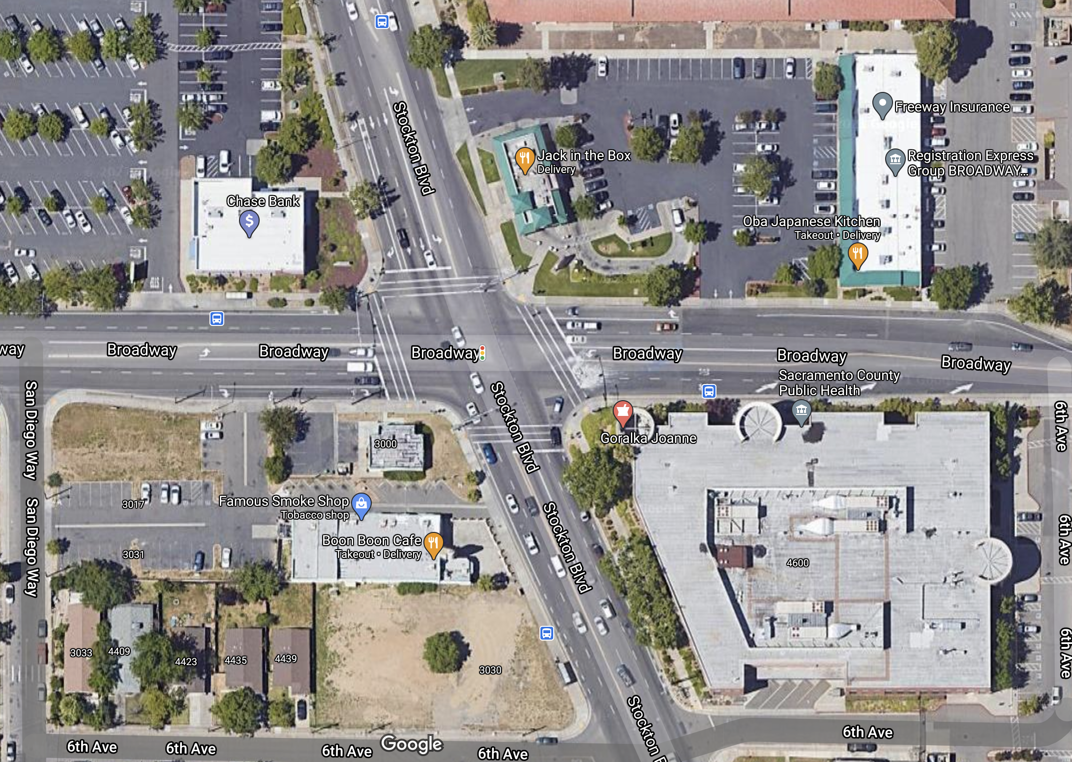
I’ve picked the intersection of Broadway and Stockton Blvd in southeast Sacramento as an example. It is certainly not the worst intersection, but it shows several of the scenarios for bike lanes.
First, an excerpt from the Sacramento Bicycle Master Plan 2016-2018 map showing existing and proposed bicycle facilities. Broadway has Class 2 bike lanes from 44th Street through 49th Street, including the intersection. Stockton has Class 2 bike lanes south of Broadway, but only proposed Class 2 bike lanes north of Broadway.
Broadway & Stockton Blvd, bicycle facilities from Sacramento Bicycle Master Plan
Second, a Google Maps excerpt of the intersection.
Broadway & Stockton Blvd, Google Maps
Southbound on Stockton Blvd, there is actually a bike lane between the through lane and the right hand turn lane. This is the type of facility that scares many bicyclists, riding between two potentially fast lanes of traffic. If you assume that the turn lane if inevitable, which it is not, then this is the only way to place a bike lane without significant intersection modification. Southbound on Stockton, there is no bike lane before this short bike lane shows up.
Northbound on Stockton, the bike lane is dashed from 6th Avenue to Broadway. The dashing, or skip line, is intended to indicate to both bicyclists and drivers that this is a merge area, with right-turning traffic merging to the right and through traffic merging to the left. Problem is, almost no drivers know what this means and how to act. California Vehicle Code (CVC) requires that a right turn be taken from the rightmost position (CVC 22100: Both the approach for a right-hand turn and a right-hand turn shall be made as close as practicable to the right-hand curb or edge of the roadway…). The purpose of this law is in part to ensure that bicyclists and drivers are in line with each other, so that the bicyclist is not right-hooked by the driver. In the turns section of the DMV Driver Handbook, none of the diagrams or text mention bike lanes, so it is not surprising that most people are unaware of the law and do not follow it.
Eastbound on Broadway, there is a bike lane present up to San Diego Way, the preceding street, but is absent in the next block. It is dropped in favor of a dedicated left turn lane and a dedicated right turn lane. Many bicyclists will ride the left edge of the right hand turn lane, and then proceed through the intersection. But most bicyclists will not even ride here because it is uncomfortable and unsafe. The bike lanes on Broadway are largely wasted because of this dropped bike lane. If a person doesn’t feel safe approaching an intersection, they don’t feel safe on their ride.
East of the intersection, the bike lane does not start up again until just past 6th Avenue. What the bicyclist is faced with is no bike lane in an area where two general purpose motor vehicle lanes are merging, which is a situation in which drivers are negotiating with other drivers, not paying any attention to bicyclists. There is a simple solution here, which is to make the right hand lane approaching Stockton be a right-turn only lane, so that the merge happens before the intersection, not after. That also removes the need for the existing right hand turn lane and provide space for a bicycle facility. To the east of the intersection, Broadway would be one lane only, as it becomes just one block later.
Westbound on Broadway, there is a bike lane from the east, but it is dropped 180 feet before the intersection, in favor of a right hand turn lane.
This is a flared intersection, where the roadway cross-section is wider near the intersection than on the approaching streets. The reason for this is to accommodate turning lanes. Stockton southbound has dedicated right turn and left turn lanes. Stockton northbound has a dedicated left turn lane. Broadway eastbound has dedicated right turn and left turn lanes. Broadway westbound has dedicated right turn and left turn lanes. Despite the flare, bicyclists have not been accommodated, only motor vehicle drivers.
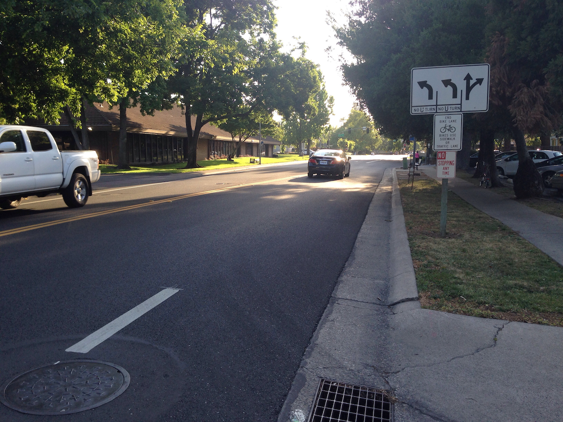
Northrop Avenue dropped bike lane, Sacramento County
I believe strongly that bike lanes should not be dropped at intersections. Never. Ever. As I’ve noted before, I’m a vehicular bicyclist who is not significantly affected by these roadway design flaws, but it is not for vehicular bicyclists that roadways should be designed. They need to be usable and comfortable for the widest possible array of bicyclist types (Four Types of Transportation Cyclists).
The perceived need by traffic engineers and drivers for dedicated turn lanes should not trump the actual needs of bicyclists for continuous and safe bicycle facilities.
It is possible to modify or reconstruct intersections so that they accommodate drivers, including turn lanes, and bicyclists, with continuous bike lanes, but that is expensive, and such changes would happen only slowly. What needs to be done NOW is to return a small part of the roadway to bicyclists by ensuring that bike lanes continue up to and through intersections. That means restriping the roadway to reallocate space. Either right turn or left turn dedicated lanes would need to be removed. I’ll leave it to the traffic engineers to decide which maintains the best flow of traffic, but I won’t leave it up to the traffic engineers to decide that it doesn’t need to be done. Though I don’t like, and most bicyclists hate, bike lanes between right turn lanes and through lanes, it is one possible solution for maintaining the right turn lane, but only when right turns are a predominant movement for the entire intersection.
Note: This is not just an issue in Sacramento. It is in the county, and the region, and the state, and everywhere in the US that I have traveled. In Oregon, bike lanes continue to the intersection, but then Oregon has the strange idea and law that bicyclists need to remain in the lane, but drivers can’t enter it. I’m not sure whether this is more safe or less safe, but it is different.
The convention center and community center theater project (3C) project did a very poor job of preserving access for walkers and bicyclists at the beginning. Some issues have been resolved, but some never have, though the project has now been going on for just less than two years.
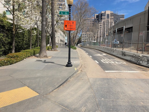
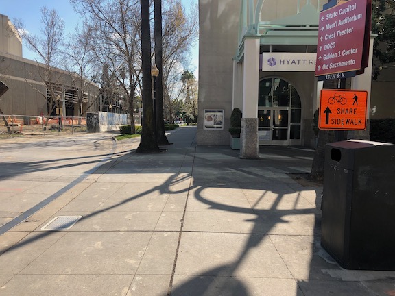
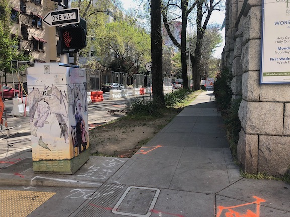
The most significant issue is that there was no provision made for northbound bicyclists on 13th Street, passing the construction between L Street and J Street. 13th is a major bicyclist route of travel, and the city knew this before the construction started. But the original traffic plan did not address this use at all. After public complaints, a sign was installed on the sidewalk for northbound bicyclists, photo below, but not the southbound. The numerous walkers using this sidewalk, adjacent to the Marriott and Sheraton convention facilities, were confused to see bicyclists on the crowded sidewalk. After more public complaints, a sign was added southbound, the second photo, though it is placed in a location where people coming from K Street would not necessarily see it. As you can see in the first photo, the sidewalk is narrow just north of the crosswalk, so bicyclists heading north are brought into immediate conflict with pedestrians heading south, many of whom are headed to the crosswalk over L Street. Of course having an angled ADA ramp here, rather than the two-to-a-corner design that should be used wherever there is significant pedestrian traffic, makes things worse.
Of course the best solution here would have been to just close 13th Street to motor vehicles between K Street and L Street, leaving the narrowed roadway available for two-way bicyclist traffic. There are far more bicyclists using this route than private vehicle drivers. Despite that, the city biased in favor of drivers.
13th Street northbound at L Street13th Street southbound at K Street
One issue on which progress was made was the southeast corner of J Street and 13th Street. Initially this corner was closed, giving walkers only one choice of how to cross, despite this being one of the most heavily used intersection crossings in the city. There was no reason to close the corner off, the area behind the fence was never used for construction. After about a year and a half, the corner was re-opened, photo below, so that walkers have a choice of routes. Note that when the city finally worked on this corner, the work was not done behind the fence, but the fence was moved and then the sidewalk and ramp work done by closing off the corner until it was done.
J Street & 13th Street, southeast corner, finally re-opened
On the east side of the project, issues remain. The sidewalk from J Street south along 15th Street has no signing indicating that it is closed ahead, see photo. When you get half way, there is just a fence blocking access. In daylight, you can see the fence ahead, but a limited vision person and anyone walking at night would not see the fence until they got to it. This is simply unacceptable.
15th Street west side, southbound from J Street, no signage
There are several other less serious issues around the east and south sides. At K Street & 15th Street, there is no signing to indicate how to get to the other side, to go either northbound or southbound. This one is not hard to figure out, at least for sighted people, but it was still not done correctly. This crosswalk ramp should have been barriered off, just like the ADA compliant barriers in the previous post, since it only leads to a closed crosswalk.
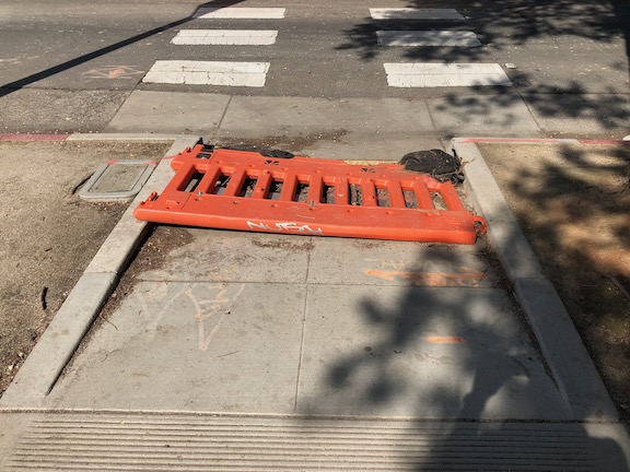
On the south side of the project, there are plastic barriers for the crosswalk over 14th Street at L Street, and for the crosswalk over L Street on the west side of 14th Street. These barriers were knocked over months ago and have not been put up again. There were not sufficient to begin with, but laying down on the ground, are both useless and hazardous.
14th Street at L Street, failed barrierL Street at 14th Street, west side crosswalk, failed barrier
I’m going to call this one a failure on the part of both the construction company and the city: the construction company for failing to monitor and maintain the traffic control devices for which they are legally responsible, and the city for failing to monitor the construction company. Blame all around!
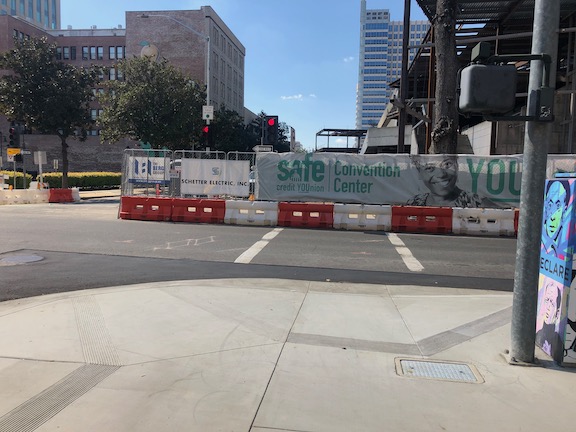
And lastly, the closure of a lane on L Street for the construction was not handled well. As you can see, there is a narrow crosshatched area the length of the block. One might reasonable choose not to go this way, but then again I see people going this way every day, both walking and bicycling. I am not sure how this should have been handled, but there must be a better solution. Of course one solution would have been to continue a temporary pedestrian walkway on the north side of the street, set off by concrete barricade, and requiring only a simple fence to separate the walkway from the construction site. If more street width was required, parking could have been removed from the south side and the general purpose lanes shifted to the left. Note there there never was a bicycle lane present in this block, it is dropped at 15th Street and the traffic sewer 3-lane roadway continues west.
L Street westbound at 14th Street, narrow shoulder
In closing, this construction project is probably the worst in the city (though there is competition). It does not involve a private property owner, it does not involve a state construction project, it is a city project on city land. There is simply no excuse for such poor walker and bicyclist accommodation. It is a big middle finger to those to who don’t drive.
M Street bike routeAs I said yesterday, I choose primarily two-way, two-lane streets to walk on, because they offer a quieter and calmer place to enjoy walking, looking around, and finding businesses to frequent. When bicycling, I’m more likely to be going someplace specific, and more likely to be in more of a hurry. If given the time, I’d almost always rather walk than bike, but bicycling certainly saves a lot of time, and so I bicycle more than walk.
The first criteria for choosing streets to bike on is traffic speed. In the grid, nearly all of the streets are posted 25 mph, but traffic speeds vary widely from 20 to 40 mph. When a street is designed for 40 and then posted for 25, motor vehicle drivers respond by going 40. Again, this is a street design issue. I am not afraid of 40 mph traffic, and I am OK mixing in with it – I’m a vehicular bicyclist, but why, when I don’t need to? So I pick other streets.
First preference is quiet streets with a design or signing welcoming to bicyclists. Best example is M Street in East Sacramento, my usual route to and from Trader Joes, and also when I jump off the parkway at Sac State and continue into downtown/midtown. Streets like M are the closest Sacramento has to bike boulevards or neighborhood greenways.
Second preference is narrow streets without bike lanes. Why? Because the traffic moves slowly on these streets, sometimes below the posted speed. Since I’m now treating stop signs as yield signs, the more frequent stop signs on these streets don’t slow me down very much, there are few vehicles to take turns with except at two brief times of day. Parking along these streets helps a lot, particularly when it is diagonal, because parked cars create friction that slows drivers.
Third preference is streets with bike lanes. But often these are higher volume, higher speed streets. If I’m really in a hurry, these are the streets I use. Fewer stop signs and fewer signals make for a faster trip. In that sense I’m making the same decision as car drivers.
Thank you, Elle, for reminding me in your “transportation ‘planning’ downtown” that I wanted to write about I Street. Note: If you are looking at Google Maps, it does not show the current lane configuration on I Street since the repaving and re-striping project of last fall, nor the realignment of tracks and work on extending 5th and 6th streets over the tracks.
I Street from the 4th Street crosswalk; I have the walk signal but this is still scary
I Street in Sacramento approaching the train station is a mess. Starting with the confusing floating bike lane between 7th and 6th streets (subject of a future post), the street becomes worse and worse: five lanes wide, high speed, and completely unfriendly to bicyclists and pedestrians. For pedestrians, the crossing on the east side of the I/5th intersection is uncomfortable because westbound traffic is already moving at high speed and often runs the red light, and right turning cars from I to 5th often do not yield to pedestrians in the crosswalk. The west side is so unsafe due to traffic turning left off 5th Street, it is signed against pedestrian crossing, even though this is a logical walking route from downtown to the train station. A crosswalk has been added on the east side of the I/4th intersection, but it has the same challenges that drivers are moving too fast and often run the run light. When I used this new crosswalk, I was very concerned, and I have a much higher tolerance for danger than most people do.
The right-most two travel lanes lead to the high-speed northbound I-5 freeway onramp, so drivers passing 6th Street are already accelerating to freeway speeds, many times going 55 mph as they cross through the I/5th intersection. The next two lanes lead to a medium speed onramp to the I Street bridge over the Sacramento river, and to the southbound I-5 onramp. For pedestrians, the only way to go westbound towards Old Sacramento is to go through the parking lot for the train station and under the onramps along an ugly, dark, poorly marked pedestrian way.
Tomorrow night (Nov. 8) at 6 PM the Sacramento City Council meets to vote to adopt a plan for the Freeport Blvd. Bike Lane project.
City staff propose replacing 4 substandard-width traffic lanes on Freeport Blvd. between 4th Ave and Sutterville Rd with 5 lanes: 2 standard-width traffic lanes and a center turn lane for motor vehicles and bike lanes in both directions (Segment Design Concept 2 on the website below). Staff also proposes bike-friendly modifications to the intersection at Freeport and 4th Ave, in front of Taylor’s Market (Intersection Design Concept 2).
The segment improvements are exactly what bicyclists need for safety, and while the intersection improvement isn’t the best one (see #4), it’s affordable and workable.This is a good plan and it looks likely a council majority is prepared to approve it.We need **100** bicyclists to attend this meeting to show the council that our community supports these kinds of essential safety improvements. If you ride on Freeport or care about the safety of someone who does, please join us and please share this invitation with others!
Questions? Contact SABA at jim@sacbike.org or 916-444-6600.
10th Street northbound at Roosevelt Park, three lanes reduced to two
As part of a recent repaving project, now mostly complete, bike lanes were added to several streets in the downtown area, sometimes by converting three travel lanes to two, and sometimes just by narrowing the travel lanes. As an example, 9th Street (one-way southbound) and 10th Street (one-way northbound) were converted from three lanes to two, which freed up space for bike lanes. 10th Street is shown at right. A reduction in the number of travel lanes is sometimes referred to as a road diet. However, the amount of right of way is the same, it has just been shifted to serve all modes of travel more effectively. The reduction in motor vehicle lanes reduces the motor vehicle road capacity slightly, but far less than many people think it will. In fact, with more space for bicycles, more people will bicycle and the motor vehicle traffic drops somewhat, lessening congestion for everyone.
I Street westbound just past 7th St; sharrow in time restricted lane
Sharrows (shared lane markings) were also used liberally throughout, particularly on east-west streets. Along I Street westbound, bike lanes are present in some blocks and sharrows in others. The photo at right shows the sharrows placed within a time restricted travel lane in front of the courthouse on I Street. When parking is allowed, the sharrows form a defacto bike lane adjacent to parked cars. This lane is a bit wider than it was before. During no-parking times, the sharrows define their usual meaning, that “Bikes Can Use Full Lane”. The MUTCD R4-11 sign is used at times to provide the same indication. Sharrows are placed in lanes which are too narrow for a motor vehicle and a bicycle to share side by side, which is less than 14 feet. In any lane narrower than 14 feet, the bicycle not only can be should occupy the middle of the lane to prevent motor vehicles from passing too closely.
Some criticisms of the project:
Sharrows are placed inconsistently within the travel lanes. They should always be centered in the travel lane, but it looks like in some cases they were placed a certain distance out from the curb. Placement too far to the right encourages motor vehicle drivers to try to squeeze by, which is what creates the hazard.
The alternating of bike lanes when there is space with sharrows when there is not space is an understandable effort to create the best solution to a challenging situation, but in my mind, it fails. Regular bicyclists often take the travel lane anyway, in order to create the necessary distance from parking cars and their dooring hazard, to bypass slow traffic, and to prepare for left turns. It is the less confident bicyclists who would benefit most from the new bike lanes, but I think they will be quite confused with the change back and forth between bike lanes and sharrows.
I think that all three lane streets in downtown should be converted to two lanes. Three lane streets encourage high vehicle speeds. It is not unusual during non-congested times to see vehicles going 40 mph on these streets, where the posted speed limit is 25. An opportunity was missed to make these conversions.
I also think that one-way streets should be converted to two-way streets. Again, one-way streets encourage high vehicle speeds, and in fact they are designed to do this, to flush cars in and out of downtown twice a day. They are called traffic sewers for a reason. Two-way streets create an environment where drivers are much less likely to speed. Of course once a street has been road dieted to two travel lanes, a conversion to two-way is much easier.
Despite these criticisms, though, I am pleased to see the new bike lanes freshly painted. I suspect this project has doubled the number of sharrows in Sacramento, and as people see them used more and more, they will become more effective. It was a pleasure riding on Sunday from my residence in midtown south to the farmers marked on 9th Street, and then back north on 10th Street.
The City of Sacramento will include on the November ballot a repeal of Measure A, from 1977, which prohibits the city from requiring green waste bins. If passed, the city has already established a policy that “the claw” would only be used during three months, November through January, and during other months, green waste bins would be required for everyone.
Why is this a transportation issue? The yard waste ends up most commonly in the bike lanes. Piles of leaves can be challenging, but branches end up in the piles as well, an almost certain guarantee of a bicycle crash. At night the dark piles don’t stand out, and I’ve hit a number of them. Once the pile is there on the street, it accumulates all sorts of other trash as well. Some jerks seem to take it as an open invitation to add household trash, and couches, and … The piles could be placed in the parking lane, but almost never are. On streets without bike lanes, the piles constitute a mine field for the bicyclist who rides close to the right. Of course one can avoid the piles by taking the travel lane, as I and many others do, but at least as many bicyclists won’t place themselves there and end up swerving back and forth to avoid the piles.
If the measure passes, we will still have three months of piles, but there should be fewer of them as many people use the green waste bins year round. In my experience, the fall is the most challenging time of year, as the abundant leaves are hit by the fall rains and decay into a slimy slippery mess. I love that Sacramento has so many trees, and therefore so many leaves, but it is still a challenge.
We’ve all experienced waste bins in the bike lanes as well, trash, recycling, and green waste. But this seems a more manageable issue to me, as the owners can be cited and the bins moved by cyclists. In my opinion, bins belong in the parking lane where one is present, and where not, in the owner’s driveway or yard. Unfortunately, law does not seem clear on this point.
Bins do not ever belong on the sidewalk. As much as I am inconvenienced by bins in the bike lane, I never want to see them on the sidewalk, where they completely block access by disabled people and make walking less pleasant for everyone. When I’m walking, I always move bins off the sidewalk and back into people’s yards or driveways. Fortunately this is not a major problem in the city of Sacramento, but is common practice in the suburbs and other cities of the region.