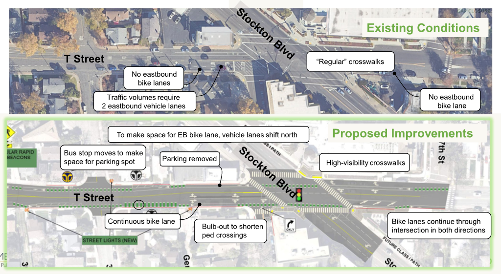
I will make comments at SacATC tonight on the T Street Bikeway Gap closure project.
This should be called an active transportation project. There are pedestrian improvements as well as bicyclist improvements, which is appropriate.
Overall, the project addresses several known safety issues, but could be improved. The modification of Gerber Ave is appreciated.
As unsafe as bicycling is through the Stockton Blvd/T Street intersection, crossing of Stockton in the south crosswalk is even more unsafe. This crosswalk must be made safe for walkers by the addition of a long leading pedestrian interval (LPI), a minimum of 8 seconds, or an exclusive pedestrian phase.
The diagram seems to show the T Street eastbound bike lane at Stockton to the right of an optional right-turn lane. The diagram indicates ‘modify traffic signal’ but does not show a bicycle signal face. Unless there is an exclusive bicycle phase for at least a part of the overall signal cycle, this is unacceptably dangerous for bicyclists.
Removal of the intersection setback on T Street eastbound is good, but will require a ‘no right turn on red’ sign or blank-out sign.
No RRFBs! They are not safe in the City of Sacramento due to driver non-compliance.
The presentation does not make it clear why the Stockton Blvd Corridor Plan recommendation to change eastbound T Street at Stockton Blvd to a single through lane was dropped. This change would greatly simplify the intersection for walkers, bicyclists, and drivers, and remove the need for a merge east of Stockton Blvd.
Caltrans should be forced to add additional lighting, which was neglected during the Fix 50 project, where 34th Street and T Street pass under Hwy 50. This should not be a city responsibility.
T St & Stockton intersection diagram, from the presentation
The city has proposed a Folsom Blvd Safety Project. See previous post on that project. I would like to present an alternative to the bicycle facilities aspect of this project, improvement of the M Street corridor. M Street, and related streets including Elvas Ave, provide an alternative route. This route is already used by hundreds of bicyclists per day, students at Sacramento State, other commuters, and recreational bicyclists accessing the American River Parkway. Folsom, on the other hand, sees very little bicycle use. This is because it feels dangerous for most bicyclists, and because it is not the most direct route for many destinations.
The lack of bicyclists does not indicate that the street does not deserve bicycle facilities. Folsom has no bicycle facilities in the section to be revised, does not feel safe for bicyclists, and is not safe for bicyclists. The classic saying is that you can’t judge the need for a bridge by the number of people swimming the river. Bicyclists deserve safety on every street.
However, since bicycle facilities are a primary feature of the project, so it is worth asking: ‘Is this the best investment of limited funds?’ I’d suggest that upgrades to the M Street corridor might be a better investment.
Neither route actually offers safe access to and through Sacramento State. M Street is a low volume, mostly low speed street, from Alhambra Blvd to Elvas Blvd, However, the section along Elvas to the Hornet Tunnel that goes under the railroad tracks, is hazardous and intimidating for bicyclists. Folsom Blvd, with this project, would provide basic bicyclist facilities from Alhambra to 65th Street. However, access to and through Sacramento State beyond 65th Street is poor. The ‘safer’ crossing of Folsom at 69th Street and Elvas Avenue is awkward, was designed for walkers and not bicyclists, and not really safe. I have observed a number of drivers blowing the red light at this crossing. After crossing Folsom, a bicyclist can jog west to Elvas Avenue, and ride that to Hornet Tunnel, though the street is very deteriorated, of widely variable width, and the entrance to the tunnel is awkward.
The map below shows both routes, M Street from Alhambra Blvd to Elvas Avenue, in orange, and Folsom Blvd from Alhambra Blvd to 65th Street. Both are of equal length. Folsom Blvd has bike lanes from Alhambra to 47th Street, and discontinuously from 49th Street to 57th Street, with nothing to the east. M Street does not have bike lanes, but is is a low volume, low speed roadway along which most bicyclists feel comfortable riding. It is a ‘low stress bikeway’. Some of the route is marked with bike sharrows. Though improvements could certainly be made to M Street, it is functional as is, as a bicycle route.
Folsom Blvd has a posted speed limit of 35 mph, and much higher speeds are routinely observed. The fatal crash was in fact due in part to egregious speed violation by a driver. The proposed project would reduce speeds somewhat due to prudent drivers, but will probably encourage passing in the center turn lane. The project would leave the posted speed limit unchanged. M Street has a posted speed limit of 25 mph throughout, and speeds above 30 mph are rare. Would bicyclists rather ride on a non-bicyclist facilities roadway with 30 mph traffic, or on a buffered and un-buffered bike lane with 50 mph traffic?
Both of these routes are unacceptable because they don’t create a safe corridor all the way to Sacramento State. However, I feel that an investment in improving the M Street corridor section along Elvas would be a better investment than bicycle facilities along Folsom Blvd which end at 65th Street.
I wrote about improving the section of the M Street corridor between 62nd Street and Hornet Tunnel earlier this year: Elvas Ave and Hornet Tunnel. I don’t have a cost estimate for this project.
I am not saying the the Folsom Blvd Safety Project is a bad idea, just raising the question of where funds can be best invested to improve safety and comfort for bicyclists.
I said in my post about the Sacramento Active Transportation Commission meeting of May 16, and in an eComment, that I was generally in support of the Folsom Boulevard Safety Improvements Project, agenda item 3. I am still in support of the project, but conversations with a number of people since them have pointed out weaknesses in the project that I will comment on.
Speed limit: The city does not propose to reduce the posted speed limit on the revised sections of roadway. The posted speed limit is 35 mph, and of course the design speed and typical speed is much higher. The reduction of general purpose (motor vehicle) lanes from four to two will result in lower speeds under some conditions, where a prudent driver sets the pace, but where there isn’t a prudent driver, other drivers will continue to travel well over the speed limit, creating the threat of traffic violence for all roadway users. Though not common, some drivers will use the center turn lane to pass slower drivers, increasing the danger for everyone. The city must reduce actual speeds with a safer design that enforces the desired speed.
Gutter pan bike lane: For several segments, the project proposes to keep the existing wide gutter pans and use them as part of the bike lane. This is probably illegal under state law, but even if not, it is poor practice. The gutter pans are acceptable in some locations, but in many cases are quite deteriorated and not rideable. Either the gutter pan must not be counted as part of the bike lane, or it must be replaced.
Lane widths: The projects indicates lane widths of 11 feet for the center turn lane and the two general purpose (motor vehicle) lanes, or 33 feet of the available roadway width. This is unnecessarily wide and will encourage drivers to travel at a higher speed than is safe. It is worth remembering that the fatality which initiated this project was due in part of excessive speed.
Bike lane design: The bike lanes are indicated as five feet. This is the minimum required by law, but is insufficient. It does not allow for safe passing of one bicyclist by another, and limits use by wider bicycles such as cargo bikes and three-wheeled bikes. The bike lane buffer is as narrow as 1.2 feet in some segments. This does not provide any real sense of security for less confident bicyclists. In some sections, the bicycle buffer has vertical delineators (shown as K-71 green delineators), but in other sections has no delineators. The narrow buffers and lack of delineators will not encourage bicyclists to use Folsom Blvd as a travel route. It might be better to improve bicycle facilities on M Street and Elvas Avenue, which is a parallel route commonly used by bicyclists, students and others, from east Sacramento to Sacramento State via the Hornet Tunnel.
Sidewalks: At no location in this entire project are sidewalk improvements shown. The sidewalks, where present, meet minimum standards, but do not have sidewalk buffers (planting strips), and there are several short sections with no sidewalk at all. Sidewalks without sidewalk buffers do not encourage people to walk. This is yet another city project with claimed safety benefits in which sidewalks are ignored as though they are not a critically important part of the transportation network. New ADA-compliant curb ramps are indicated in a few locations, but safer crossings are irrelevant if travel along the corridor is discouraged.
Slip lanes: The slip lane for 51st Street southbound at Folsom is retained. The small pedestrian island between the two travel lanes is not comfortable for walkers. The project also retains slip lanes for Folsom Blvd eastbound to 65th Street south, and 65th Street eastbound to Folsom Blvd east. Slip lanes are hazardous for all roadway users, and should be removed whenever a street in reconfigured.
Center turn lane: As with almost every project the city has proposed, there is a center turn lane along the entire length. I consider these to be a waste of roadway space except where the frequency of turning movements, to or from the major roadway, justify a center turn lane. Otherwise, they are just empty, seldom used space that could be better allocated to other uses.
Driveway closures: Driveways are the single feature that creates the most difficulty for people rolliing, and people walking. Commercial properties should be limited to one driveway in/out, of 20 feet, or two driveways, one in, one out, or 20 feet each. Twenty feet is required for commercial driveways by fire regulations. Where driveways are available on side streets for commercial properties, they should be used and driveways on the main roadway closed or greatly narrowed.
48th Street flared intersection: The intersection of 48th Street to the south has a flared design, with extremely wide turning radii, leading to a crossing distance curb to curb of 140 feet! This is a crossing that intimidates walkers, yet the project makes no effort to correct this, or even acknowledge it.
In summary, this project presented as a safety improvement project has major weaknesses that reduce its effectiveness for safety. Remember that the fatality was on a sidewalk, and the result in part of a speeding driver. It was not a bicyclist. Of course I am in favor of higher quality and safer bicyclist facilities, but it seems to be the view of the city that if things are improved for bicyclists, walkers can be ignored. I strongly disagree.
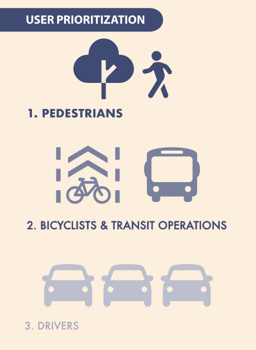
This is another city project that could be transformative, but falls short. The city is unwilling to make our streets significantly safer by prioritizing walkers over others. The General Plan has this diagram. Worth repeating again and again, until the city finally takes it seriously.
I have to admit that I missed a number of these issues when I quickly scanned the project document. If readers see additional issues that I have missed, please comment.
The cross-sections below are from the project document. Each is option two, which has more visual separation of bicyclists from motor vehicles by using buffers and/or vertical delineators. Option one does not provide any separation. But the buffers reduce the bike lane widths to five feet. Whether narrower bike lanes with visual protection, or wider bike lanes with no separation except a white stipe, are better, is a question I do not have a clear answer for. But modern bikeway designs provide both visual, or actual, protection, and wider bike lanes. These bicycle facilities are the minimum acceptable.
Folsom Blvd cross-section, 47th to 53rd, option 2Folsom Blvd cross-section, 53rd to 63rd, option 2Folsom Blvd cross-section, 63rd to 65th, option 2
So the neglect of the Central City Mobility Project for fixing these two blocks of I Street is disturbing. Of the people riding on I Street anywhere west of 16 Street, probably 50% are going to Sacramento Valley Station. But if you spend time on I Street looking for bicyclists, you won’t see many. The average bicyclist won’t ride on I Street. They are uncomfortable with the volume and speed of motor vehicle traffic, but more importantly, they are scared to death of these two one-block sections with only sharrows. So they drive to, or have someone drop them off at, the station. Sacramento Valley Station is the most important transit hub in the city, in the county, and in Northern California outside of the Bay Area, yet the city has neglected access to the station.
The TIRCP grant for improvements at Sacramento Valley Station may improve access from the station on H Street, but again, that is not a near term project, and it is not clear how effective it will be. Probably 80% of the riders on H Street are coming from the station. (Sac kill those sharrows on H St, H St bicycle fixes)
My observation of bicyclist numbers and destinations is based on observation and talking to some riders. It would be nice if the data were available, but I don’t have it, and apparently the city doesn’t have it, or at least has never shared it publicly. I know that the city purchased cell phone data several years ago that would have allowed them to see bicyclist patterns, but so far as I know, they only used it for motor vehicle drivers patterns.
I St shadows between 10th St and 9th St, Sacramento
My last three posts have been about locations where sharrows replace bike lanes for one-block sections in the Sacramento central city: Sacramento’s worst possible place for sharrows; Sac kill those sharrows on I St; Sac kill those sharrows on H St. There may well be other such locations that did not come to mind. If so, please let me know so I can document and post on them. I’m not asking about locations that should have bike lanes, or where bike lanes should be upgraded to separated (protected) bikeways. There are simply too many of those locations for me to deal with.
So, why are bike lane gaps so important? Bike lanes are basically a promise to bicyclists that the city is providing a safe place to ride your bike. Yes, I know traditional bike lanes have serious safety issues (they are called door zone bike lanes, or DZBLs), but for the average rider, they are safer than no bike lane. But this promise is broken when there is a gap. For these gap sections, bicyclists who felt comfortable riding in a bike lane are suddenly left to deal with motor vehicle traffic in a location where neither the bicyclist nor drivers are sure how to behave. What does the average bicyclist then do? Decide never to ride on that street again. And if they have a scary experience, they may even decide not to ride again at all.
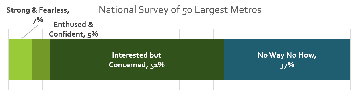
I’m a bicyclist with strong vehicular bicycling skills. I know where the safest place to ride is on every street, and I ride there no matter what motor vehicle drivers or law enforcement happens to think about it. But I am far, far from a typical Sacramento bicyclist. I am ‘strong and fearless’, though as I get older, I’m tending towards ‘enthused and confident’. The four types of bicyclists, or levels of comfort, developed in Portland but applicable to Sacramento, are shown in the graphic:
The city should be designing bicycle facilities that work for all three categories of people who will bicycle. When there is a gap in a bike lane, the city has designed bicycle facilities that serve the ‘strong and fearless’, only 7% of potential bike riders. This is discriminatory. It is wrong. I suspect that with the resurgence of bicycling and the availability of e-bikes, the ‘no way, no how’ category has shrunk a bit.
The city must close bike lane gaps. Not off in the future when the street is repaved, or when a grant is obtained, but NOW. To do otherwise is to intentionally discourage bicycling and to risk people’s lives.
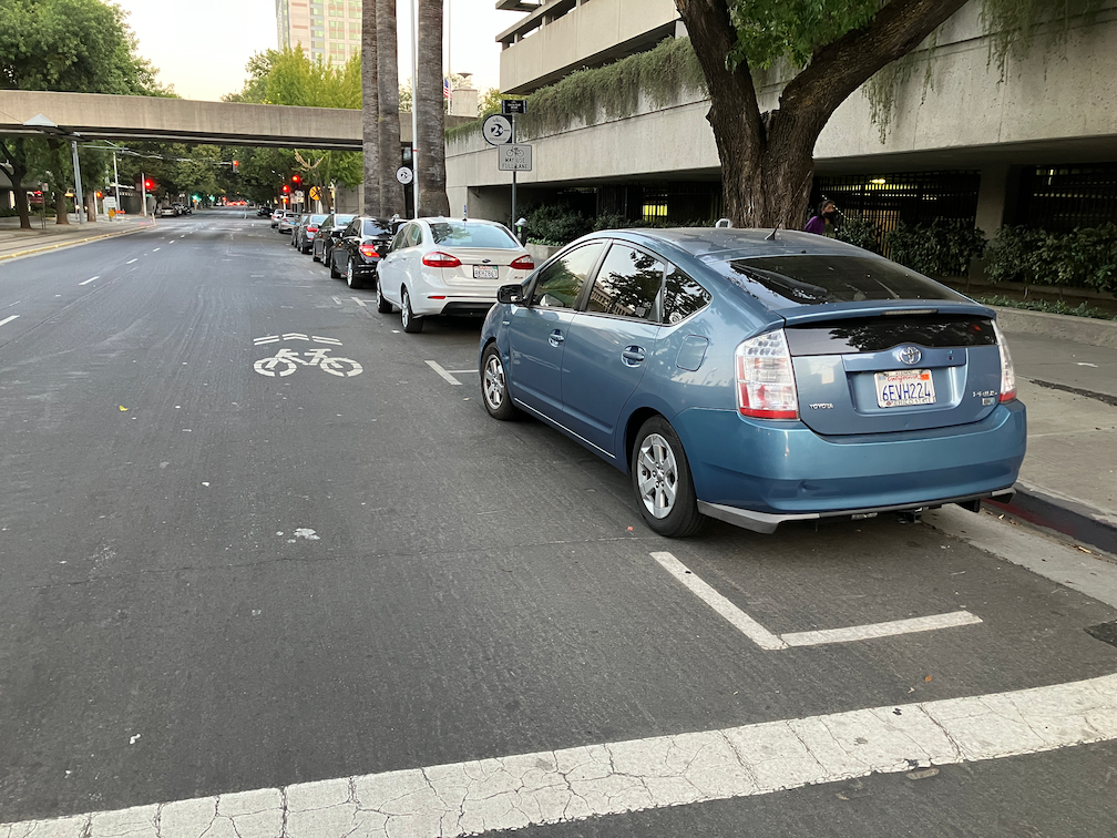
The third place where sharrows need to be eliminated in the central city Sacramento is I Street at the county jail. In the phot below, the right hand lane is a parking lane most of the time, except for commute rush hour, 4:00-6:00PM on weekdays (note the time sign in the ‘bikes may use full lane’ photo following), when it is a general purpose lane. When it is a parking lane, there are sharrows nearly covered up by parking, as you can see in the second photo. This is not a bike lane in any sense of the word, but drivers assume that it is and close pass anyone using that area to ride in. When it is a general purpose lane, there is high speed traffic approaching the Interstate 5 onramps, absolutely not an appropriate location for sharrows. The current trend in use of sharrows is 1) don’t use them at all; 2) if they are used, they should absolutely never be used over 35 mph, and rarely used over 25 mph. Though the posted speed limit of I Street is 25 mph (though it isn’t really posted anywhere), regular traffic speeds are over 35 mph, and during commute hours is over 45 mph except when congestion prevents that. So this is not any appropriate location for sharrows.
Of all the places where bicyclists are at risk of getting doored, this is the place. Everyone parking here has a family member or friend who is in jail. They are upset, they are depressed, they are often angry, they are not thinking about bicyclists and looking before they open their door. There is also a lot of turn-over here, so a lot of door opening. When I ride this area, I ride in the exact middle of the next lane over, taking the lane. But that is something that the average bicyclist will not do. So the sharrows leave them vulnerable to both close passing and dooring.
The city has placed a ‘bikes may use full lane’ sign (MUTCD R4-11), but is is up high against the background of a tree, where it would not likely be noticed by drivers or bicyclists. Of course bicyclists may use the full lane, with or without the sign, but again, most bicyclists will not do that. If signing is to have any meaning at all, the sign must be much bigger than it is, closer to 7th Street, and the message should also be marked on the pavement.
I St west of 7th St, part-time parking and general purpose lane with sharrows, SacramentoI St west of 7th St, sharrows and parking in a part-time general purpose lane, SacramentoI St west of 7th St, bikes may use full lane sign
I am not sure what the best solution is here. It is not to get rid of the parking; this is one location where on-street parking is justified. The right hand lane should be a parking only lane, however. There is no justification of traffic volume requiring another general purpose lane during commute times. That just encourages more driving and higher speeds, as drivers race each other for the on-ramps.
This is also a location where bicyclists separate into two destinations. Riders heading towards Sacramento Valley Station stay on the right so they can turn on 5th Street toward the station. Riders heading to Old Sacramento must move to the left hand side to avoid the high speed on-ramps. The left side bike lane, however, doesn’t even start until just before 5th Street, leaving no refuge for bicyclists trying to merge across traffic to the left side between 7th Street and 5th Street. I think there needs to be an intentional location for bicyclist to shift, at 7th Street or 6th Street or 5th Street. There would be a green bicycle box for waiting, and a signal with exclusive bicycle phase for bicyclists to safety transition from the right side to the left side. A bike lane would be present from that crossing point on I Street, without gaps.
Of course I Street needs to be reallocated so that it serves all users, and is not just a traffic sewer for drivers going to the freeway. It should be no more than two lanes at any location. Fewer lanes would slow traffic, as the prudent driver sets the speed rather than the egregious speeder. There should be a separated (protected) bikeway on either the left or right side, with a safe transition from one side to the other at some point.
Caveat: I post about issues in the central city because I live here, and see the problems every time I am out walking or bicycling. However, I strongly believe that the city should be focused on solving issues in lower income, disinvested neighborhoods, of which there are ample throughout the city. The central city has received more than its share of bike facilities.
The block of H Street between 7th Street and 8th Street in downtown Sacramento has shadows instead of a bike lane. There is a bike lane in the preceding block, and in the block past, but not this block. Why? Because on-street parking has been preserved on this block in preference to bicycle facilities. The right lane lane is marked with a sharrow. Not a properly placed sharrow, but one in the door zone of the parking lane. When shadows are used, they should be placed in the center of the travel lane. But rare is the situation in which they should be used at all. Research indicates that sharrows are less safe than no markings are all, less safe than marked bike lanes.
So why is this parking here at all? No reason whatsoever. On the north side of this block is a County of Sacramento parking garage. There is even a pedestrian bridge between the parking garage and the Sacramento County administrative building on the south side of H Street, as seen in the photo.
I am certain that all of these cars belong to county employees or contractors. They should be parking in the garage, and this parking should be removed so that at least a marked bike lane can be placed in this block. Of course H Street should have a separated bikeway from 6th Street, Sacramento Valley Station, to 16th Street, where it becomes two-way. But a Continous painted bike lane is at least a first step.
There are a number of locations in the central city where bike lanes are dropped for a block in favor of parking and travel lanes. Every single one of these should be fixed either by the removal of parking or a general purpose lane.
Caveat: I post about issues in the central city because I live here, and see the problems every time I am out walking or bicycling. However, I strongly believe that the city should be focused on solving issues in lower income, disinvested neighborhoods, of which there are ample throughout the city. The central city has received more than its share of bike facilities.
Many organizations and individuals are deciding to oppose the transportation sales tax measure being proposed for the November 2022 ballot in Sacramento County. The reasons for opposition are many, but previous posts here (Measure 2022) cover significant ones. If the measure does not qualify for the ballot, or does qualify and fails, what then are we to do for transportation? Below are some ideas for a safe and effective transportation system. They are not yet well organized or prioritized.
I acknowledge the contribution of Walkable City Rules by Jeff Speck to this list. If you haven’t read it, please do. I don’t agree with everything he says, but it is the best prescription for correcting our transportation system and healing our cities that I know of. See also Measure 2022: the path not taken.
The realities of climate change and social justice demand a radical redesign of our existing transportation system and radical shift in transportation policies and investments. More of the same, with slight improvements, as the sales tax measure suggests, will not serve our needs now or in the future. See also our racist and classist transportation system.
General
all projects must contribute to or be neutral in reaching regional (SACOG) and state goals for reducing VMT and GHG (vehicle miles traveled, greenhouse gas emissions)
travel modes will be prioritized as: 1) active transportation (walking and bicycling), 2) transit, and 3) motor vehicles
Equity
sales taxes are regressive, and will not be the default mechanism for funding transportation projects
travel needs of people who don’t or can’t drive (children, elderly, disabled, choice) will receive at least the same concern and investment as those who do drive
at least 60% of transportation investments must serve formerly underinvested communities
transportation projects will be selected and designed to meet community needs previously expressed through community engagement; projects will not be selected by transportation agencies or employees
anti-displacement measures will be included in all transportation projects
no investments will be made in transitioning motor vehicles from fossil fuels to electric or hydrogen, except where formerly underinvested communities need supporting infrastructure; transitioning vehicles away from fossil fuels merely maintains motor vehicle dominance of our transportation system
all projects over $10M will require a health impact analysis
agencies will educate the public about H+T (housing and transportation) costs as a measure of housing affordability
Policies
roadways will be maintained in a state of good repair to serve all travel modes
transportation planning will be integrated with land use planning
only agencies that acknowledge and plan around induced travel demand will receive transportation funding
all transportation agencies must implement a robust complete streets policy which includes frequent, safe crossings of roadways and speed reductions
congestion pricing will be considered as a solution in all dense urban areas, to reduce motor vehicle travel and to fund transportation projects; pricing will be based at least in part on vehicle weight, value or emissions
cities and counties will not accept responsibility for maintaining local roadways in new developments; therefore, new development must establish reserve accounts to cover ongoing maintenance
Vision Zero
all transportation agencies must establish and implement Vision Zero policies in which redesign of roadways is a preferred action
at least 25% of transportation funds must be spent on Vision Zero projects
all roadway fatalities will be analyzed using a safe systems approach, with required change to the roadway design or use to prevent future fatalities
Roadway Design
implement 10-foot or less travel lanes whenever a roadway is repaved; remove striping from local streets
all new developments will require a grid street system of one-eighth mile so that the need for arterials and collectors is reduced
consider all right-turn-only and left-turn-only lanes for elimination
eliminate slip lanes everywhere
require signal cycles to be 90 seconds or less
eliminate level-of-service (LOS) in transportation planning
conversions of one-way streets to two-way streets will be funded; one-way one-lane streets will be considered an acceptable design for local streets and central cities
overly wide roadways will be reduced, with unneeded right-of-way returned to adjacent property owners or sold for infill housing
rougher pavements such as brick will be considered whenever slower traffic speeds are desired (but crosswalks will be smoother than the pavement)
Traffic Enforcement
wherever possible, automated enforcement will be used to enforce vehicle code that protects vulnerable users, rather than direct enforcement by law enforcement officers
violations which to do not threaten the safety of other roadway users will be de-prioritized or removed, with reduced fees if maintained
temporary or permanent vehicle confiscation will be used for egregious violators of vehicle codes
cities and county shall have the authority to do city-wide and county-wide reductions of posted speed limits, with or without corresponding changes to roadway design; redesign is of course preferred
Parking
all on-street motor vehicle parking in urban areas will be charged, either through curb metering or though flat fees
parking fees will be used to:
cover the cost of providing on-street parking construction and maintenance, and parking enforcement
improve transportation and economic vitality within the neighborhood that generates them, and therefore will not go into the general fund
parking minimums will be eliminated
de-couple parking from rent so that car-free renters are not subsidizing renters with cars
parking will be managed to maintain a level of availability on every block (similar to the Shoup 85% rule)
removal of on-street parking for higher uses such as active transportation, dining, and community spaces will be supported; however, removal of a travel lane rather than removal of parking is preferred
remove parking upstream of intersection corners to ensure visibility (daylighting); not needed when curb extensions provide the visibility
parking lanes/areas will be maintained to a reduced and less expensive level than roadways
Freeways
freeway removal, reduction, or decking will be considered for all freeways
new interchanges must be 100% paid for by private development
in urban areas, reconnect street networks over or under freeways at no less than one-half mile intervals, and provide pedestrian and bicyclist connections at no less than one-quarter mile intervals
managed lanes must be converted from general purpose lanes, not created through capacity expansion
Transit
transit performance measures will be developed, with a tentative goal that 80% of the population is served by 15 minute or better frequency bus or rail service, within one-half mile, for at least 15 hours per day on weekdays and 12 hours per day on weekends
transit will not be used as a mitigation for roadway expansion or induced motor vehicle travel; transit is a desirable mode in and of itself
transit will be funded to at least the equivalent of one-half cent of sales tax
dedicated bus lanes or bus rapid transit (BRT) design will be implemented on all high ridership bus routes
transit agencies will have flexibility to allocate funds between capital, maintenance, and operations, based on established criteria
metered freeway on-ramps serving four or more regular (non-commute) buses per hour will have bus bypass lanes
Sidewalks and Crosswalks
sidewalks will be considered an integral part of the transportation network, and therefore maintained by transportation agencies rather than property owners, except where trees or work on private property impacts the sidewalk; buffer strips in which trees are planted will be considered public responsibility
sidewalk infill will be considered a primary use of transportation funds, with at least 60% going to formerly underinvested neighborhoods
sidewalks with driveway ramps that slope the sidewalk crosswise will be replaced with continuous flat sidewalks, or the driveway eliminated
all traffic signals that have a pedestrian signal head will be programmed with a leading pedestrian interval (LPI) of at least 3 seconds
required pedestrian-activation will be eliminated (buttons to trigger audible information are acceptable); pedestrian auto-detection will be considered
raised crosswalks or raised intersections will be the default design for all reconstructed intersections
all crosswalks will be marked, with the possible exception of purely residential areas
pedestrian crossing prohibitions will be analyzed and eliminated where not strictly necessary for safety
curb extensions, the width of parking lanes and designed to not interfere with bicycling, will be installed whenever intersections are modified or reconstructed
Bicycle Facilities
bike facilities on any roadway with a posted speed limit over 30mph must be separated (protected) bikeways
bike facilities on any roadway with a posted speed limit over 40 mph must be separated from the roadway
roadway design will be used to make bicycle facilities unnecessary on low speed streets
design and implement low-stress bicycle networks
prioritize filling gaps in the bicycle network
re-stripe or re-design roadways so that bike lanes or separated bikeways are not dropped at intersections
bike share, and possibly scooter share, will be supported with transportation funds
secure, on-demand bicycle parking will be provided at common destinations; bicycle racks will be provided at common destinations and on every block in urbanized areas
Schools
school districts will have the authority to close roadways fronting the main entrance to a school, during arrival and dismissal times, in order to increase student safety and protection from air pollutants
Safe Routes to School programs or similar will be supported by transportation funds at the local level
school districts will be prohibited from building new schools at locations which are not easily accessible via active transportation or transit
school districts will prioritize neighborhood schools over magnet schools, in order to reduce travel
school districts will develop policies that allow neighborhood schools to remain open under declining enrollment
school districts will be responsible for the same transportation demand management requirements placed on any other entity
Thank you if you read all the way through. I realize some of these are radical ideas, but radical ideas make space for more reasonable ideas provided by others. That is part of the purpose of this blog.
SACOG in the 2013 funding round allocated $9M to the Riverfront Reconnection project in the City of Sacramento. This phase extends 2nd Street from Old Sacramento to Capitol Mall, providing an easier access to Old Sacramento, and also adds sidewalks to O Street and improves sidewalks and bike lanes on Capitol Mall between 3rd Street and the Tower Bridge. The overall purpose is to create or restore connections between downtown Sacramento and Old Sacramento which were severed by Interstate 5.