I worked for 10 years as the Safe Routes to School Coordinator for San Juan Unified School District. Three of those years were focused on Citrus Heights schools, and the rest on schools in unincorporated Sacramento County (Orangevale, Fair Oaks, Carmichael, Arden-Arcade, and Gold River). The interchanges with Interstate 80 presented barriers for students who lived on one side and went to school on the other. They could not walk or bike across the freeway, because the interchanges were designed to be safe only for motor vehicle drivers (and not really even those), not to be safe for walkers and bicyclists. Crosswalks over on-ramps and off-ramps were placed where drivers would cross them at freeway speeds, with poor visibility due to the curves. Bike lanes were usually non-existent, and when they were there, exposed bicyclists to high speed merges at on-ramps and off-ramps. If you have ever had the ‘pleasure’ of walking or riding across one of these interchanges, you will know how scary and unpleasant they are. Generally only ‘fearless’ bicyclists and people who have no other choices will walk or bicycle here.
Since these horrible interchanges were designed and constructed by Caltrans, you might think that they are responsible for fixing them. They deny responsibility. They say to cities and counties, if you want a better interchange, you build it on your own money, or with grants. One of the interchanges in Citrus Heights, Antelope Road, was repaved by Caltrans, and they removed the bike lane from the westbound direction. Of course that bike lane was not safe to begin with, but removing it was criminal.
Same Caltrans denial of responsibility for ped/bike bridges over the freeway. There is one ped/bike bridge over I-80 in the entire stretch between Sunrise Blvd and Watt Ave, a distance of about eight miles. One. And it is no a pleasant crossing to use, often full of trash and graffiti. Again, to the cities and counties, Caltrans says, if you want it, you pay for it, don’t expect it to come out of our budget.
Given this, Caltrans will not even allow the application of complete streets designs to these interchanges. They want them to remain as they are, barriers to travel, and killers of the few walkers and bicyclists who use them.
All of this after spending four years developing a new complete streets policy, which could have been done in a year if Caltrans were not dragging its feet. Caltrans says that it has changed its ways, and is now concerned with people who walk and bicycle. Their actions say otherwise.
The Sacramento area book club gathering for Walkable City by Jeff Speck continues on the second Wednesday of October, October 11, 6:00PM to about 7:30PM, at Lefty’s Taproom, 5610 Elvas Ave, Sacramento.
The book section for this gathering is ‘The Comfortable Walk’ (page 211), with Step 7: Shape the Spaces and Step 8: Plant Trees. The 10th Anniversary Edition also contains ‘More Comfort’ (page 345). The Sacramento Public Library has a copy of the 10th Anniversary Edition (2022) and the original edition (2012). Local bookstores may have a copy on hand, but if not, can order it in few days. It is also available as an Amazon Kindle e-book and Audible audio book. The last gathering will be Wednesday, November 8, and will cover ‘The Interesting Walk’ (page 235), with Step 9: Make Friendly and Unique Faces and Step 10: Pick Your Winners.
You do not need to have attended a previous book club gathering. If it is your first time, welcome! You also do not need to have read the relevant sections of the book, but you will probably enjoy the conversation more if you have. Previous participants have included transportation and housing professionals, but also just interested citizens. We want you, we want your voice and ideas! We realize that some people have a hard time getting somewhere at 6:00 sharp after work or other obligations, so come when you can, and jump in.
An Eventbrite event has been set up to let us know you are coming: https://www.eventbrite.com/e/walkable-city-jeff-speck-book-club-tickets-728394807477. However, a ticket is NOT required, you can just show up. Getting a ticket helps us plan, and provides the ability to have it entered on your calendar, so you don’t forget, but please come in any case.
Lefty’s Taproom has a wide selection of beer, and some wine and cocktails, and non-alcoholic drinks. They also have a variety of dinner items. You are not required to drink or eat, but it does help support our venue. We meet outside on the patio, so come dressed appropriately. Sunset will be at 6:35PM that day. There is bike parking at the front entrance. Lefty’s is a 10 minute walk from SacRT route 30, or a 30 minute walk from SacRT Gold Line light rail. There are good bicycle facilities on Elvas, but not necessarily on streets connecting to Elvas.
Work is occurring on I Street this week. The street has been marked from 21st Street to 12th Street, and some of the white striping has been completed. No green paint yet. This section is all right side of the street bikeways.
The design is rather erratic:
21st Street to 20th Street, parking protected separated bikeway
20th Street to 19th Street midblock, bike lane
19th Street midblock to 16th Street, buffered bike lane
16th Street to 13th Street, buffered bike lane
13th Street to 12th Street, parking protected separated bikeway
At the intersection of 21st Street and I Street, there are markings for dashed green bike lanes on the west, south, and east legs, adjacent to the crosswalks (not yet painted). No sign of the promised bike signal yet. The markings imply to me that bicyclists continuing north on 21st Street will have to make a two-stage crossing, first across 21st Street, and then across I Street. This is not what was advertised, which was that bicyclists would have an exclusive signal phase during which they could go to any of the three destinations without any moving motor vehicle traffic. To to seen.
21st St & I St intersection bike lane markings
At 20th Street, the street becomes three motor vehicle lanes (general purpose travel lanes) and a curb-side regular bike lane. I’m guessing this is to provide stacking area for motor vehicles when trains are crossing. Makes some sense, but it also makes the bikeway erratic, and will encourage poor behavior as drivers speed into the third lane, and then have to merge back into two lanes.
I St at 20th St, unprotected bike lane and three motor vehicle lanes
At 16th Street, the street design is two motor vehicle lanes and a buffered bike lane. The reason for this is that the Memorial Auditorium loading dock extends into the street, which was an earlier design mistake that the city made to choose auditorium convenience over people walking (Sac permanently closes sidewalk).
I St at 16th St, two vehicle lanes and buffered bike lane
12th Street is the end of the project, and I Street is again a three-lane traffic sewer towards the freeway. At 6th Street it becomes a five-lane traffic sewer.
Since work is actively going on today, I would guess that the white paint will be complete by the end of this week, and green paint added next week. There is still a national shortage of the green K-71 vertical delineators, so I would guess that only a few will be placed in the near future. There are a few places with gaps in the white stripes, which will be a designated color for parking or loading.
In a measure of how much the world has changed, strongly pro-business Comstock’s Magazine has come out with an article, Free Parking? It recognizes that abundant parking everywhere does not promote economic success, but in fact handicaps it. Several properties that have been repurposed from parking to higher uses are mentioned, and there are quotes from one of the largest developers in the city. The article recognizes that the success of midtown is in part due to the removal of parking minimums years ago.
I attended the Sacramento Transportation Authority (SacTA) last Thursday (2023-09-14). Though I really wanted to complain about the continuing funding of the climate arson Capital Southeast Connector, I held my tongue, to concentrate on the voter survey presentation. The presentation was a brief version of the whole document (see SacTA hears voter survey), highlighting the most critical parts. The jist of the presentation is that a measure on the 2024 ballot would probably fail at about 55%, well below the 67% necessary for passage of an agency-sponsored measure.
The SacTA board members accepted the bad news, and were discouraged, but seemed fairly fatalistic about it. There was a recognition for some board members and a staff person that the failed 2022 Measure A (‘citizens measure’ sponsored by developers) had lessened the chances for future transportation measures even though this one was not sponsored by SacTA. A board member expressed hope that maybe a new and true citizen measure might come up, and other board members nodded. There was general agreement that another ‘same old, same old’ measure was never going to pass. There was also voiced resistance from at least two board members against any taxes, though that is not the consensus of the board. The item was up for presentation and discussion, not for decision.
I encouraged, and several board members supported, looking in more detail at Mayor Steinberg’s proposal once there is enough detail to clearly understand.
My statement to the board was (not word for word):
Transit needs more funding in order to meet air quality and GHG reduction targets in MTP/SCS, so doing nothing is not a good answer. SacRT is the lowest funded transit agency in California for a city of its size.
Low public support is due in part to the horrible 2022 Measure A, which the public recognized was designed as a gift to greenfield developers and freeway builders, and did not address the transportation needs of the county
The public has never seen a measure or proposed measure that was designed to establish and meet goals for transportation investment, so they are leery of any new measure
Mayor Steinberg’s proposed housing and transportation measure is something different, it addresses real needs in the county, with 1/3 to affordable housing, 1/3 to transit, and 1/3 to active transportation and safe streets
If the public were aware of an innovative and progressive measure, I believe voters would be much more supportive
Though no organizations have formally come out in favor of the mayor’s, it is likely that support would be present. At the same time, if another business as usual measure is proposed by SacTA, it will be opposed. The transportation advocacy community knows how to kill bad measures, and will again.
I have been getting questions from several people about how the turn wedges being installed as part of the Central City Mobility Project are supposed to work. In particular, this applies to all of the concrete wedges, which are at the intersection of the separated bikeways, but applies most of the other wedges as well.
First, the diagram from the Central City Mobility Project design document. This is turn wedge style 3, with concrete turn wedge. The other four styles have speed bumps and vertical delineators.
diagram, Central City Mobility Project, turn wedge style 3
Second, a photo of an actual concrete wedge in place.
photo, concrete turn wedge at 21st St & P St
The issue that has been pointed out by more than one reader is that a motor vehicle driver can also cut between the turn wedge and the curb, to the left of the turn wedge, rather than to the right, as was intended by the design. Wow! That is a flaw. How did this happen?
Well, the city has designed partially rather than fully protected intersections. Not only are these protections only on one corner, but they are not designed according to NACTO (National Organization of City Transportation Offices) guidance. Here is the NACTO diagram, from the Protected Intersections page.
NACTO Protection Intersection diagram
What is different? Look at the approach from the left side of the diagram. There is a concrete island, labeled 3, which prevents motor vehicle drivers from cutting through between the turn wedge (‘corner island’ is the NACTO term) and the curb. It is likely that the area labeled 1 would also be a concrete island. This island not only protects bicyclists, but more importantly, protects walkers and shortens the crossing distance. I will include text from the NACTO page below, because the details are really important.
So, how to fix the Sacramento problem? Concrete islands need to be installed in the upstream direction, before the crosswalk. In the case of the photo above, this would be where the photographer is standing. Without such protection, this cannot be considered in any way a protected intersection or separated bikeway (protected bikeway). The radius of the turn wedge is also much greater than the NACTO recommendation, 30 feet rather than less than 18 feet (see second bullet below). So we are back to ‘turn wedges of death‘. I have to say, this is typical of the city, to take a good idea and sort of implement it.
Thank you to the reader who pointed out this design flaw, and caused me to look more closely, and think more closely.
I’m traveling, first in Las Vegas area, and now in Los Angeles area. Traveling to other places is a good reminder that Sacramento is not all that bad. There are worse places!
In Las Vegas, everyone drives everywhere. I observed a person jump in his Jeep, drive a half block to his mailbox, and drive back home. Walking to and from his front door, and to and from his mailbox (clustered mailbox), I saw no sign of disability. In fact, the prevalence of Jeeps is amazing. Every third suburban house has one. Cause you know, its wild out there. The number of them with dirt on the undercarriage, however, is infinitesimal. I see people leaving their house to drive and get coffee, and drive back home. Not as part of a chain of errands, but a drive just to get coffee, for no other purpose. Of course much of Las Vegas is so spread out, that it may to a long ways to a coffee shop (see coffee shops (tea) on the grid for a contrast). Every new development I saw is a gated community. I’m not aware of any being built or recently built that are anything but gated. Even the apartments are gated. People live in, and want to live in, a world where they don’t have to interact with other people, any more than absolutely necessary. They drive large vehicles with darkly tinted windows. They don’t know their neighbors, nor do they want to. The ‘living in a quiet neighborhood where you know your neighbors’ is a mythology perpetrated by people who want to defend their lifestyle, while preserving their isolation.
The worse thing about the neighborhood where my sister lives is the lack of any real shade. Though I celebrate the end of front yard lawns, trees seem to have been thrown out with the bathwater (‘throw the baby out with the bathwater’). Most front yards do not have trees at all, and the ones that do, they are mesquites and related trees, which are beautiful but provide almost no real shade. Except in the very oldest parts of the Las Vegas area, all sidewalks are attached, meaning no space for street trees. If they aren’t on private property, they pretty much don’t exist. Of course that doesn’t matter, because no one walks, so there is no need for shade. Not quite true. Everyone has a dog, or multiple dogs, and takes their dog for a 10-minute walk every day so they can leave their dog waste in someone else’s front yard. If you haven’t spent time in the Las Vegas area, it is always at least 5 degrees hotter than Sacramento, and up to 20 degrees hotter. It is a place that could really benefit from sidewalk shade, but doesn’t have it. Wait, I haven’t been fair. There are palm trees, everywhere. Shade? Nope. Wildlife value? Nope. Aesthetics? Nope.
There are a lot of bicycle riders in southern Nevada. They drive to the paved trails and to unpaved trails at the edge of the city. They don’t ride in the city.
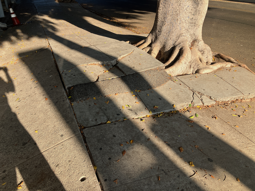
Now I’m in Los Angeles. I have to say that people are much more friendly here. Complete strangers will start up conversations. And you do see a lot more people walking. There are sidewalks on every street. However, except along the main arterial roads, every block has a major issue the sidewalk, often root heaves that make the sidewalk impassible to people with mobility devices, and sometime even to abled walkers. If not root heaves, then there is just deterioration, big cracks and gaps. Bike lanes are scarce in the City of Los Angeles and unincorporated areas of the county. A few of the cities have really put in bike facilities, but in general, they just don’t exist. Because most of Los Angeles is on a grid, there are often lower speed, lower volume parallel streets to ride, but don’t bother with the major streets, or trying to get somewhere quickly.
I have been walking around Koreatown this afternoon, refreshing my memory and experience of the sidewalks. It is nearly impossible to walk a block, on any street except the arterial roadways, without running into a sidewalk issue that would make it difficult or impossible for someone in a wheelchair to navigate. The reason root heaves are so prevalent here is that the sidewalk buffers are only three feet, except in richer neighborhoods. Even Sacramento has six feet or more for sidewalk buffers (where they exist). So every tree that is older has root heaved the sidewalk (photo below). If it isn’t a root heave or deterioration, then a motor vehicle is parked across the sidewalk, blocking it. In several miles of walking, I have yet to see anyone using a mobility device, except in the grocery store. Are they staying home? Are they driving? Are they using transit? They aren’t rolling on the sidewalks!
impassible root heave, 9th St in Koreatown, Los Angeles
I know I complain often about the built environment in Sacramento, and the very slow progress in correcting the mistakes and disinvestment of the past. All of that is true. But…
Sacramento has a great tree canopy in much of the city, and where it does not, everyone recognizes that there is a problem and I believe the city is making an honest effort to correct that (though handicapped by the same issue that lower income neighborhoods were built with attached sidewalks (no sidewalk buffer for trees). Though there are some areas of gated communities, they are mostly in the county, not the city. Other than our governor, most people don’t live behind gates. It seems to me that there is nowhere near as much dislike of other people as is present in southern Nevada.
The central city has good bike facilities, and relatively polite drivers, at least for bicyclists (not walkers), and is flat. Flat. And the central city is getting better, and work is or will be done on some of the arterial roads in the suburbs, though it is many years late and many dollars short. But it is happening.
I really like living in Sacramento. Of course I go to the bay area frequently, and it in most ways does not compare well with that. But it certainly compares well with Los Angeles, and Las Vegas area. Las Vegas is really just a suburb of LA anyway. 75% of the people came from LA, and the rest from Utah. But every place has its challenges, and I know my perception is just one of many.
For quite some while, the project on 19th Street had stopped at Q Street, but it is now continuing south to W St. White striping is done, there is some green paint but incomplete, curb and line colors for special parking is not started, and there are no vertical delineators. The block from Q Street to the light rail tracks is a buffered bike lane, due to a street dining area at Midtown Spirits. At the tracks, there are some swooping lines, that I think are intended to encourage bicyclists to cross the tracks at a closer to perpendicular angle, but it is not finished so I can’t tell if it being properly marked. The remaining blocks to W Street are parking protection separated bikeway.
19th St at Q St, buffered bike lane
The section from W Street to Broadway has not been worked on. As is true of most of the separated bikeways, it is on the left side. South of Broadway, 19th Street becomes Freeport Blvd and is two way, with the southbound bike lane on the right side. At the moment, there is nothing to indicate how and where a bicyclist would transition from right side to left side. The two blocks are devoted to general purpose (motor vehicle) lanes, and is not a comfortable place for a bicyclist to be.
In the design diagrams, the transition appears to be at W Street, with no particular accommodation for bicyclists. Though the design diagrams do not indicate operations, just striping and signing, it looks as though bicyclists will cross W Street on the east side, with the regular signal, and then 19th Street on the south side, with the regular signal. There is no indication that the bicyclist crossing 19th Street will be protected from left turning motor vehicle traffic by an exclusive phase. Green paint is not sufficient communication for most drivers, hard physical control is required, such as no left turn during the bicyclist movement. I suspect, based on city implementation in other locations, that it was decided that an exclusive bicyclist phase was ‘not practical’ because it would slow motor vehicle drivers a bit.
19th Street from W Street to Broadway
I believe that the city should develop and install signing specifically for bicyclists on the transition points, where a bikeway either ends or transitions to the other side. There is no indication that the city has done or intends to do this. The diagram indicates a R55(CA) (MOD) sign on the southeast corner, which is a mystery, since the standard R55 sign is ‘yield to uphill traffic’. Of course neither the federal MUTCD nor the California CA-MUTCD, which is similar, has much in the way of guidance or signage for bicycle facilities, since in the mind of FHWA and Caltrans, bicyclists are an afterthought. There are several note references around this intersection, several of which I have been unable to locate in the design document, but they must exist somewhere. Be aware that the city has ‘invented’ a number of traffic control signs that are not compliant with CA-MUTCD, so the excuse that there isn’t an official sign is just stonewalling on the part of the city.
I Street
There has been no work on I Street in quite a while, since the resurfacing, but there are new ‘no parking’ signs posted with control starting today, 2023-09-19, so perhaps work is about to start again.
My previous post on Mayor Darrell Steinberg’s transportation measure proposal was based on the August 25 press conference and panel discussion which included Elk Grove Mayor Bobbie Singh-Allen, Steve Cohn of SMART (Sacramento Metro Advocates for Rail and Transit), Cathy Creswell, Chair of Sacramento Housing Alliance, Luke Wood, President of Sacramento State, and Gabby Trejo of Sacramento Area Congregations Together (SacACT).
For affordable housing, there are three sub-programs:
Creation of new affordable housing on vacant or underused infill sites and along existing commercial corridors and/or transit lines: infill housing rather than greenfield development (which can never be affordable because lower housing costs are more than counterbalanced by higher transportation costs)
Preventing displacement and homelessness: keeping people in their homes so they don’t become homeless
Green Means Go: enhancing infrastructure needed to support affordable infill housing
For public transportation, it would fund high priority public transit improvements, with four elements:
Bus rapid transit countywide. This element was important enough to Steinberg that he highlighted it on his webpage, table below. Note that light rail extension is a possible future enhancement to BRT to Elk Grove and the airport, but it does lock in these extensions are other proposals have.
Expanding service & frequency on existing transit lines
Light rail fleet replacement and station renewal
Regional (Intercounty) Transit Network/ express bus services
For safe streets and active transportation, there are two sub-programs:
Fixing the roads and active transportation
Innovative mobility: unfortunately, the focus is on motor vehicle electrification, and not e-bikes and shared mobility devices
Note that though the documents calls for a half-cent sales tax, Steinberg said he is open to other funding ideas including property tax. He also implied that if the rest of the county is not on board with an innovative investment strategy or tries to water it down with the traditional road building and widening methods, the city would go its own way.
Certainly we need more detail, but I support the vision that Steinberg’s proposal puts forth. Almost of all of our transportation expenditures in the past have disinvested in, or active harmed, communities of low income and people of color. They have continuously widened and extended roadways, mostly for the benefit of high income suburban commuters. They have built and over-built transportation infrastructure that we will never have enough money to maintain, and insisted on building more rather than taking care of what we have. They have actively discriminated against people who walk and bicycle. They have ignored the established fact that adding roadway capacity induces more travel, so that ‘congestion relief’ is always out of reach.
It is time for a new approach, and I believe that Steinberg’s proposal is an important step along the way to a better future.
This afternoon (2023-09-14, 1:30PM), the Sacramento Transportation Authority (SacTA) will hear from consultants about a survey of likely voters and attitudes toward a transportation sales tax measure. Agenda item 13 is available (the entire agenda packet is so long that it is hard to find this item; this is a low resolution version).
The survey indicates that only 54% would vote yes, which is less than the 67% required for passage, assuming that the measure is sponsored by SacTA, and not a citizen initiative.
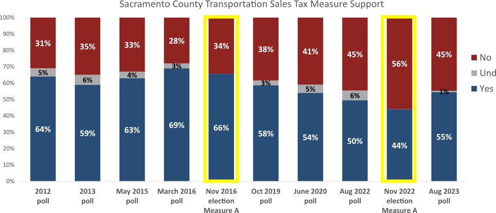
There are a lot of interesting bar charts, in the presentation. Below is just one, showing the level of support in various surveys and actual elections over time. I recommend you take a look at the whole document to see what jumps out for you.
Sales Tax Measure Support over time
The presentation does not really address what I think is a key factor, which is the cynicism developed by voters over time when the same failed policies get presented again and again. The 2016 Measure A, the withdrawn 2020 Measure A, and the landslide failure of 2022 Measure A presented transportation investments that are more of the same: more highways, more interchanges, more roadway capacity, more air pollution, more greenhouse gas emissions. The voters have never been offered an alternative that does not represent the interests of traffic engineers who always want more: more cars, more concrete, more ribbon cuttings, more money. Particularly after the 2022 developer-sponsored ‘citizen initiative’, voters don’t trust that sales taxes will be spent on what they actually need for livability and economic vibrancy. 2022 Measure A was just more money in the pockets of greenfield developers and highway builders. Money out of the voters pockets.
But there is now an alternative, Mayor Darrell Steinberg’s proposal. I wonder if that were presented to the public, what the level of support would be. More about that in the next post.