Central City Mobility update: 19th St

This is Central City Mobility Project update #24.

For quite some while, the project on 19th Street had stopped at Q Street, but it is now continuing south to W St. White striping is done, there is some green paint but incomplete, curb and line colors for special parking is not started, and there are no vertical delineators. The block from Q Street to the light rail tracks is a buffered bike lane, due to a street dining area at Midtown Spirits. At the tracks, there are some swooping lines, that I think are intended to encourage bicyclists to cross the tracks at a closer to perpendicular angle, but it is not finished so I can’t tell if it being properly marked. The remaining blocks to W Street are parking protection separated bikeway.

photo, 19th St at Q St, buffered bike lane
19th St at Q St, buffered bike lane

The section from W Street to Broadway has not been worked on. As is true of most of the separated bikeways, it is on the left side. South of Broadway, 19th Street becomes Freeport Blvd and is two way, with the southbound bike lane on the right side. At the moment, there is nothing to indicate how and where a bicyclist would transition from right side to left side. The two blocks are devoted to general purpose (motor vehicle) lanes, and is not a comfortable place for a bicyclist to be.

In the design diagrams, the transition appears to be at W Street, with no particular accommodation for bicyclists. Though the design diagrams do not indicate operations, just striping and signing, it looks as though bicyclists will cross W Street on the east side, with the regular signal, and then 19th Street on the south side, with the regular signal. There is no indication that the bicyclist crossing 19th Street will be protected from left turning motor vehicle traffic by an exclusive phase. Green paint is not sufficient communication for most drivers, hard physical control is required, such as no left turn during the bicyclist movement. I suspect, based on city implementation in other locations, that it was decided that an exclusive bicyclist phase was ‘not practical’ because it would slow motor vehicle drivers a bit.

design diagram, 19th Street from W Street to Broadway
19th Street from W Street to Broadway

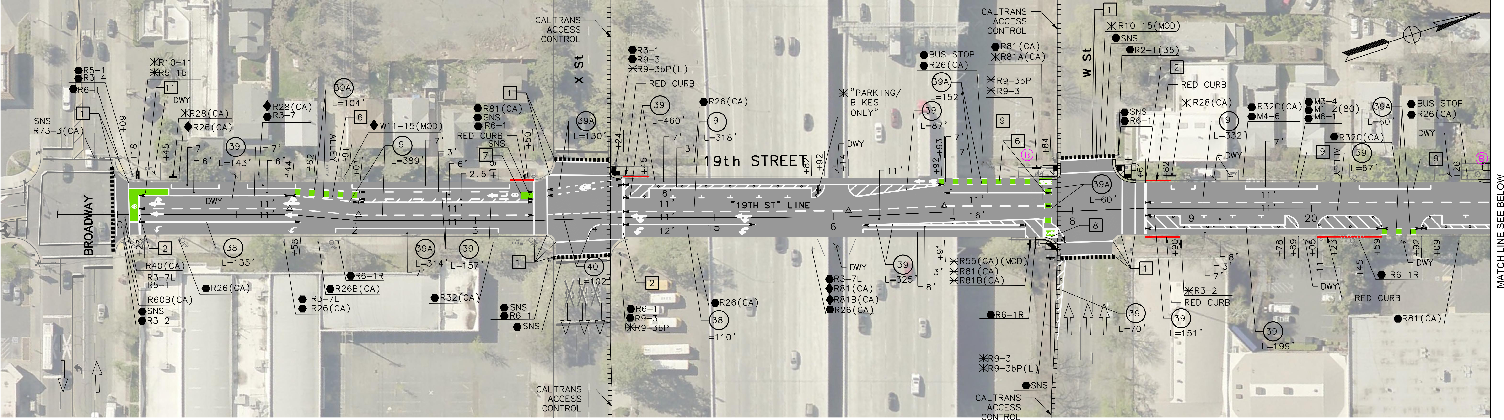
I believe that the city should develop and install signing specifically for bicyclists on the transition points, where a bikeway either ends or transitions to the other side. There is no indication that the city has done or intends to do this. The diagram indicates a R55(CA) (MOD) sign on the southeast corner, which is a mystery, since the standard R55 sign is ‘yield to uphill traffic’. Of course neither the federal MUTCD nor the California CA-MUTCD, which is similar, has much in the way of guidance or signage for bicycle facilities, since in the mind of FHWA and Caltrans, bicyclists are an afterthought. There are several note references around this intersection, several of which I have been unable to locate in the design document, but they must exist somewhere. Be aware that the city has ‘invented’ a number of traffic control signs that are not compliant with CA-MUTCD, so the excuse that there isn’t an official sign is just stonewalling on the part of the city.

I Street

There has been no work on I Street in quite a while, since the resurfacing, but there are new ‘no parking’ signs posted with control starting today, 2023-09-19, so perhaps work is about to start again.

more on Steinberg’s transportation and housing proposal

My previous post on Mayor Darrell Steinberg’s transportation measure proposal was based on the August 25 press conference and panel discussion which included Elk Grove Mayor Bobbie Singh-Allen, Steve Cohn of SMART (Sacramento Metro Advocates for Rail and Transit), Cathy Creswell, Chair of Sacramento Housing Alliance, Luke Wood, President of Sacramento State, and Gabby Trejo of Sacramento Area Congregations Together (SacACT).

A ten page summary of the proposal offers more detail on ‘The Climate, Clean Transportation, and Affordable Housing Act of 2024‘. The proposal offers three major program areas, each of which would receive about one-third of the revenue generated.

  1. Affordable housing and displacement prevention
  2. Investing in public transportation
  3. Safe streets and active transportation

For affordable housing, there are three sub-programs:

  • Creation of new affordable housing on vacant or underused infill sites and along existing commercial corridors and/or transit lines: infill housing rather than greenfield development (which can never be affordable because lower housing costs are more than counterbalanced by higher transportation costs)
  • Preventing displacement and homelessness: keeping people in their homes so they don’t become homeless
  • Green Means Go: enhancing infrastructure needed to support affordable infill housing

For public transportation, it would fund high priority public transit improvements, with four elements:

  • Bus rapid transit countywide. This element was important enough to Steinberg that he highlighted it on his webpage, table below. Note that light rail extension is a possible future enhancement to BRT to Elk Grove and the airport, but it does lock in these extensions are other proposals have.
  • Expanding service & frequency on existing transit lines
  • Light rail fleet replacement and station renewal
  • Regional (Intercounty) Transit Network/ express bus services
table of Proposed Bus Rapid Transit Corridors

For safe streets and active transportation, there are two sub-programs:

  • Fixing the roads and active transportation
  • Innovative mobility: unfortunately, the focus is on motor vehicle electrification, and not e-bikes and shared mobility devices

Note that though the documents calls for a half-cent sales tax, Steinberg said he is open to other funding ideas including property tax. He also implied that if the rest of the county is not on board with an innovative investment strategy or tries to water it down with the traditional road building and widening methods, the city would go its own way.

Certainly we need more detail, but I support the vision that Steinberg’s proposal puts forth. Almost of all of our transportation expenditures in the past have disinvested in, or active harmed, communities of low income and people of color. They have continuously widened and extended roadways, mostly for the benefit of high income suburban commuters. They have built and over-built transportation infrastructure that we will never have enough money to maintain, and insisted on building more rather than taking care of what we have. They have actively discriminated against people who walk and bicycle. They have ignored the established fact that adding roadway capacity induces more travel, so that ‘congestion relief’ is always out of reach.

It is time for a new approach, and I believe that Steinberg’s proposal is an important step along the way to a better future.

SacTA hears voter survey

This afternoon (2023-09-14, 1:30PM), the Sacramento Transportation Authority (SacTA) will hear from consultants about a survey of likely voters and attitudes toward a transportation sales tax measure. Agenda item 13 is available (the entire agenda packet is so long that it is hard to find this item; this is a low resolution version).

The survey indicates that only 54% would vote yes, which is less than the 67% required for passage, assuming that the measure is sponsored by SacTA, and not a citizen initiative.

There are a lot of interesting bar charts, in the presentation. Below is just one, showing the level of support in various surveys and actual elections over time. I recommend you take a look at the whole document to see what jumps out for you.

bar chart showing Sales Tax Measure Support over time
Sales Tax Measure Support over time

The presentation does not really address what I think is a key factor, which is the cynicism developed by voters over time when the same failed policies get presented again and again. The 2016 Measure A, the withdrawn 2020 Measure A, and the landslide failure of 2022 Measure A presented transportation investments that are more of the same: more highways, more interchanges, more roadway capacity, more air pollution, more greenhouse gas emissions. The voters have never been offered an alternative that does not represent the interests of traffic engineers who always want more: more cars, more concrete, more ribbon cuttings, more money. Particularly after the 2022 developer-sponsored ‘citizen initiative’, voters don’t trust that sales taxes will be spent on what they actually need for livability and economic vibrancy. 2022 Measure A was just more money in the pockets of greenfield developers and highway builders. Money out of the voters pockets.

But there is now an alternative, Mayor Darrell Steinberg’s proposal. I wonder if that were presented to the public, what the level of support would be. More about that in the next post.

darkness of Caltrans

You might assume from the post title that this is about the climate-killing actions of Caltrans, particularly District 3, which continues to expand highways, with full knowledge of induced demand, and makes life difficult for agencies that would like to improve underpasses and overpasses for walkers and bicyclists. And there is plenty to say about that. But in this case it is literal.

Caltrans is adding capacity to Hwy 50 through Sacramento. In order to do so, they have filled in the space between the two directions of travel. For all the street underpasses, this means that there is now a single bridge rather than two separate ones. There is no longer this gap for daylight to reach the street, so it is much darker. Caltrans could have placed additional lighting in these locations, but they did not. A multimillion dollar project, and they couldn’t afford a few additional lights. They did fix most existing lights, many of which had been out for years, but they did not add any.

This is a big middle finger to people walking, as it is really quite dark under the freeway now.

This really came home to me when I went to the farmers market under the freeway last Sunday. The market is between W and X, and 6th and 8th. It was so dark that it was difficult to see the produce. I had to use my phone flashlight to examine vegetables. The pricing signs were almost impossible to read. One vendor had actually put up lights, and a number of vendors apologized for how dark it was.

Caltrans has essentially killed off this farmers market, because they were too cheap, or too oblivious, or too mean, to install lighting. I won’t be going back. I’m angry, and every person who goes to this market, or pays taxes that Caltrans uses to make things worse, should be angry.

Park(ing) Day in Sacramento

Park(ing) Day, an event that repurposes street parking spaces in creative and fun ways, is Friday, September 15.

“Park(ing) day is a global, public, participatory project where people across the world temporarily repurpose curbside parking spaces and convert them into public parks and social spaces to advocate for safer, greener, and more equitable streets for people.

The Park(ing) Day website (https://www.myparkingday.org) map shows two locations in Sacramento, but doesn’t have any additional information. The two are 1998 J Street and 2500 16th Street. 2500 16th may be the old Tower Records location, currently an empty lot awaiting development. 1998 J is the intersection of J and 20th. There have been Park(ing) Day events on this block of 20th in the past.

American Society of Landscape Architects (ASLA) has coordinated Park(ing) Days in the past (2022), but there isn’t any information for 2023.

If you have more info, please provide a comment.

Central City Mobility update: turn wedges

This is Central City Mobility Project update #23.

Concrete islands have been installed for the turn wedges at P & 21st, P & 19th, Q & 19th, and just today, at P & 9th and Q & 9th. The planned locations of these turn wedge islands are the intersections of the separated bikeways. The Q & 21st one is not installed yet, and I did not see any on 10th. The other intersections will have a different treatment, rubber speed bumps and vertical delineators.

The islands are centered by stamps red concrete. The curbs are four inches, and sloped at about 45 degree angle. Apparently these are poured on top of the pavement, I did not see any sign of excavation below the surface.

In a brief observation, about 20% of the turning drivers hit these islands. This is not surprising, as they are new, and drivers have gotten used to taking these corners at high speed, passing over what was just painted areas. I admit I almost hit one, as I had been riding straight through these intersections rather than swooping with the markings. But I pay more attention that most drivers, so I didn’t hit it.

Apparently the purpose of these is not to provide a wait area or bike box for bicyclists, but to slow drivers and have them pointing more perpendicularly to the bikeway and crosswalk, so they are more likely to see other people. But they do offer an area where bicyclists can get out ahead of and more visible to drivers.

concrete turn wedge island at P St and 21st St

Updates

P Street, Q Street, 21st Street: No significant changes.

19th St: Markings for the separated bikeway are marked from Q Street at least as far south as S Street. Not observed south of there.

I Street: No change, still just lane marking tabs. Paving was continued to 12th Street, so it is possible the project will be extended that far, but as designed, the separated bikeway and lane reduction ends at 15th Street.

10th Street: No significant change, is largely complete but some marking and delineators are still missing.

9th Street: I had speculated that the project would not be completed from L Street to Q Street, but it has been marked and partially painted now. There is a left side regular bike lane (two white lines but no buffer) from L Street to O Street, then mixed left side bike lane and separated from O Street to Q Street.

5th Street: No change.

SMART hosts Stockton Blvd envisioning

SMART (Sacramento Metro Advocates for Rail and Transit) is hosting Envisioning Our Transportation Future: The Renaissance of Stockton Blvd, on September 27, 2023, 5:30 to 7:00PM. Tickets are free (but not unlimited) via Eventbrite. Check the registration page for more information about the event and the panelists.

From the registration page: “Join us for a transformative panel discussion on shaping a sustainable and prosperous future for Stockton Boulevard. This historic corridor, linking East and South Sacramento, is on the brink of unprecedented growth — but its potential is constrained by outdated transportation infrastructure.”

I encourage you to participate, whether you live or work along Stockton, or are just interested in the evolving community needs of one of the most dis-invested neighborhoods in Sacramento (and Sacramento County – significant part of the roadway are in the county).

The City of Sacramento came up with a tepid Stockton Blvd Corridor Plan in 2021, putting bandaids on the road to try to increase safety, but unwilling to really reduce motor vehicle throughput or speeds. The city has recognized that the plan did not and does not meet the evolving needs of the area and is now proposing a BRT (bus rapid transit) route along much of Stockton. The details of that upgrade are not available. The Stockton Blvd Plan, Community Working Version (draft) from 2022 treats the larger area around Stockton Blvd and all aspects of the built and cultural environment.

SMART graphic for Envisioning Our Transportation Future

bike and scooter share back in Davis

The City of Davis and UC California Davis have created a new bike and scooter share program with vendor Spin (Spin E-Bikes and E-Scooters Launching in Davis This Fall). I was in Davis yesterday, and did not see any of the bikes or scooters, but I was not looking for them. There is going to be a slow roll-out, and I don’t know how many are on the street yet.

Davis was previously part of the JUMP/Uber bike-share regional system, but dropped out when JUMP pulled out of the area. JUMP/Uber was bought, in part, by Lime and Lime now operates with former JUMP bikes in Sacramento and West Sacramento.

Davis is requiring that devices be parked correctly, with economic consequences for not parking properly, in order to meet one of the main concerns about earlier programs. Spin will make adaptive devices available on request, which were not available in the earlier programs.

Spin Access offers lower prices for people who qualify based on CalFresh or similar low-income programs. Note that Davis is not yet listed as a city option, but it should be soon.

Spin – Shared Micromobility (City of Davis)

Spin Shared Micromobility Program (UC Davis)

$5 billion, or reduce cars

The number of $5 billion (or more) has been bandied about recently as the amount of money we need to fix all the poorly designed and dangerous roads in the City of Sacramento. The number seems reasonable, and I myself have estimated that sidewalk repair alone is $1.5 billion. This is just the city, let alone the county or region. The county and region are in most cases much worse off than the city. I support more funding for this work, some via sales taxes, but more via property taxes. After all, it is property that requires our transportation infrastructure and benefits from a good system.

But what if there is a better way? A less expensive way?

I encourage you to watch the latest (August 24) episode of Not Just Bikes (by Jason Slaughter), titled ‘Even Small Towns are Great Here (5 Years in the Netherlands)‘. He has collected video clips from visits to small towns across the Netherlands. He has two main points about small towns: almost all of them are served by good rail service, and many of the small towns and suburbs don’t need extensive bike structure because there are so few motor vehicles that it is safe and comfortable to ride on any street. My favorite quote from the video is:

“To make a place friendly for cycling, it was more important to restrict cars than it was to build a bunch of expensive bicycle infrastructure. After all, protected bike lanes are just an extension of car infrastructure, right. You don’t need bike paths if you don’t have a lot of cars.”

Not Just Bikes (Jason Slaughter)

A related quote, that I will have to paraphrase, since I can’t find the original source is: We have plenty of space for bikes on our streets, its just that it is currently occupied by cars.

The point, for me, is that we could make much more effective investments if we greatly reduced the number of cars on the road rather than trying to make all our roads safe for bicycling and walking. We need to make car drivers pay the true cost of their transportation choice: fossil fuel extraction, climate change, air pollution, expensive highways, foreign wars and fossil fuel subsidies, and a long list of others. Yes, and making it necessary to build protective infrastructure for walkers and bicyclist to protect them from those drivers. We need to make is more expensive and less convenient to drive, so that people will make other choices.

If we actively and directly reduce car dominance, we might only need $1 billion to fix everything. Still a lot of money, but not out of reach.

Jason moved to the Netherlands from Canada, but the car dominated ‘no places’ that he left are the same car dominated ‘no places’ of the United States, and of Sacramento. In fact, Canada tried to imitate the US, and left themselves impoverished, both economically and mobility wise.

Imagine for a moment, someone saying “Carmichel, where there are so few cars that it is safe to bicycle and walk on any street, and the are great transit connections to all the regional destinations.” They would be laughed out of the room. Yet Carmichael, and unincorporated town in Sacramento County, is about the same size as many of the small cities called out in the Not Just Bikes video. We have designed a horrible world in service of the idea that we can and should drive everywhere. We if we flip that and make it hard and expensive to drive everywhere, places will begin to heal. Even Carmichael.

Steinberg’s proposal for 2024 county ballot measure

Mayor Darrell Steinberg used his third State of the City address on Friday to introduce his concept of a housing and transportation measure for the 2024 ballot, called the ‘Climate, Clean Transportation and Affordable Housing Measure’. The half cent sales tax would generate about $8-9 billion over the 40 years, and the transportation aspects would be administered by Sacramento Transportation Authority (SacTA) which administers the current Measure A. More detail is available on the Mayor’s Community Engagement website https://engagesac.org/blog-civic-engagement/2023/8/25/a-new-vision-to-fund-affordable-housing-and-transportation.

One-third would go to a countywide housing trust fund, to provide affordable housing, permanent supportive housing, and other types. One-quarter of the one-third would be devoted to keeping people in their housing so they don’t become homeless to begin with.

Another one-third would go for public transportation. Specifically, initiate bus rapid transit routes, increase bus frequencies on all routes, buy new fleet, and create express buses across the region.

The other one-third would be for safe streets and active transportation. Implement vision zero, build sidewalks and protected bike lanes, multipurpose trails, car and bike share, and repair roads, all with an equity lens.

All of these investments would help the city and county reach the agreed-upon greenhouse gas (GHG) reduction target of 19% for the region.

Steinberg acknowledged that there will be opposition from the old guard, who want to keep doing the same things that don’t work and have never worked for most citizens of the city and county.

He pointed out that transit cannot be effective unless we achieve a density of housing and destinations that allows transit to work.

The mayor said that he would prefer a countywide measure, but would go for a city measure if the other partners (county and the four cities) are not interested. He emphasized several times that climate change compels us to change directions and invest more wisely.

Panel

A panel was composed of Elk Grove Mayor Bobbie Singh-Allen, Steve Cohn of SMART (Sacramento Metro Advocates for Rail and Transit), Cathy Creswell, Chair of Sacramento Housing Alliance, Luke Wood, President of Sacramento State, and Gabby Trejo of Sacramento Area Congregations Together (SacACT).

I won’t detail the panel questions and answers, except to say that there was a recognition among all that housing and transportation are inextricably linked. If you watch the video of the session, note that the first ten minutes is dead air space, and the quality of the video is poor. But still worth watching.

As I say, “You can’t have affordable housing without effective transit, and you can’t have effective transit without a density of housing and services”.