SacCity parking revisions meeting
Revised 2024-11-14, to add detail
Yesterday the city held a Zoom meeting entitled ‘SacCity Parking Revisions Community Project Update Meeting’. The second and last meeting is today, 5:30PM, via Zoom. Registration is required, at https://us02web.zoom.us/meeting/register/tZMlf–gqjwsHdbLbRtxQ1_-59HFgLSajWJx#/registration.
The city is developing what it calls a ‘Parking Strategy‘ with a ‘Parking Management Toolkit’. This is not a parking management plan, which the 2040 General Plan requires. Though the city keeps claiming that it already has a Parking Management Plan, that is being revised, no such plan exists. More than half the 190 page Parking Strategy document is Appendix A ‘Economic Conditions and Housing Development Funding Assessment’ (page 68 of the pdf) and Appendix B ‘Best Practices Research’ (page 83 of the pdf) with examples from other cities and standards. A twelve page Executive Summary provides key information for those who don’t have time for the whole document.
The parking revision process is led by Community Development Department, under Senior Planner Vic Randall, vrandall@cityofsacramento.org, but Public Works is also participating, under Parking Manager Staci Hovermale, shovermale@cityofsacramento.org. The presentation was mostly by the W-Trans consultant, Brian Canepa.
I encourage you to attend and comment. In particular, pay attention to what is excluded as well as included. Kendra Ramsey of CalBike had some of the best questions and comments, so I hope she can be on the Zoom again today.
In addition to the meeting, you can also comment via email to ParkingRevisions@cityofsacramento.org, or by adding comments to the document via konveio at https://sacramento.konveio.com/parking-strategy-public-review-draft.
Read More »this week 2024-11-11
Added SacTA on Thursday.
SacMoves Coalition hosts an event calendar at https://sacmoves.org/events/, which is maintained by STAR (Sacramento Transit Advocates and Riders) and Getting Around Sacramento.
It is understandable when agencies and organizations schedule events in conflict, as there are only so many days and times in the week, but when a single agency schedules in conflict with itself, ack! Get it together, City of Sacramento.
Monday 11
- SacRT Board Meeting (canceled)
Tuesday 12
- SacCity Law & Legislation Committee, 11:00 AM, Traffic Deaths Emergency Declaration
Wednesday 13
- Parking Revisions online workshop, 10:00 AM
- Truxel Bridge Community Open House, 5:30 PM, SMUD Museum of Science and Curiosity, 400 Jibboom St, Sacramento, CA 95811, registration not required
- SacCity Neighborhood Connections workshop, 6:00 PM, online
- CalBike 30th Anniversary Party, 6:00 PM
Thursday 14
- SACOG Board of Directors, 9:30 AM
- Sacramento Transportation Authority (SacTA), 1:30 PM
- Parking Revisions online workshop, 5:30 PM
Friday 15
Saturday 16
Sunday 17
Denver’s approach to sidewalk maintenance
Denver is implementing a unique approach to sidewalk maintenance (Denver’s Sidewalk Program). Rather than making the individual property owner responsible for sidewalk maintenance, the city will charge all property owners a fee which will be pooled city-wide to maintain or install sidewalks. It is a flat fee for most parcels, but with a progressive fee based on sidewalk footage for parcels with a lot of sidewalk.
The City of Sacramento, and most governments in California, make sidewalk maintenance the responsibility of individual property owners. State law allows this, though does not require it. You can see the results for yourself: broken sidewalks due to root heaves, discontinuous sidewalks, lack of ADA ramps. And the city and cities within the county and the county are not the worst in California. If you want to see truly horrible sidewalks, visit the City of Los Angeles, where root heaves from too narrow sidewalk buffers have broken or destroyed most sidewalks in the city.
Denver, recognizing that the model of individual property owners paying was not working, and under the threat of lawsuits, decided to take a different approach, making maintenance and installation the responsibility of all property owners. This is an immense improvement over the Sacramento and California model, though still falls short.
Sidewalks are a part of our transportation network, in fact are the most important part of that network. As such, they should be maintained, and gaps filled, as part of the regular transportation budget of cities, counties and the state. Making them a special case with special funding, or ignoring them completely, leads to a deteriorated and missing sidewalk network that actively discriminates against people who use the sidewalks to walk, roll, and, in some cases, bicycle. Every broken sidewalk and every missing sidewalk is a abject failure of the government to fulfill its responsibility to citizens to create a transportation system that serves everyone. Transportation engineers will always, if given the choice, prioritize motor vehicles over everyone and everything else, so we must compel them to meet their true responsibilities.

Is sales tax for transportation the wrong approach?
There are three ideas for transportation funding floating around, for the 2026 ballot, though none have been formalized. All rely on sales tax.
- Sacramento Transportation Authority (SacTA) may create a ballot measure to fund transportation. It would be in addition to the existing Measure A, and might fund transportation infrastructure for infill housing, which has not been done before. As an agency-sponsored measure, it would require 2/3 vote to pass.
- Sacramento Metro Rail and Transit Advocates (SMART) and Mayor Darrell Steinberg have drafted measure that would fund active transportation, transit, and housing. It would probably be for the county, but could be just for the City of Sacramento. As a citizen initiative, it would require only 50% + 1 to pass, a much more achievable vote.
- SacRT it considering a measure for transit and related active transportation that might cover only a part of Sacramento County, the more transit-supportive part, probably the cities of Sacramento and Elk Grove. As an agency-sponsored measure, it would require 2/3 vote to pass.
Sales taxes are regressive, meaning that low-income people pay a much larger percentage of their income to sales tax versus high-income people. Most organizations which lead with equity are opposed to further sales tax increases, feeling that enough is enough.
In Sacramento County, with a strong anti-tax voice in the low density unincorporated county, it is difficult though not impossible to reach the 2/3 threshold. The 2016 transportation sales tax fell short of 2/3. Measures to fund schools districts are more likely to pass. A complicating issue is that Elk Grove recently passed a sales tax measure to fund many purposes, one of which is transportation. Folsom and Rancho Cordova have sales taxes for which it isn’t clear to me whether any goes to transportation.
General purpose sales tax measures, which may list uses but are not required to follow those lists, only require 50% + 1 to pass. That flexibility is both a feature and a danger, since a government may shift sales tax income from what they said it would be spent on to other purposes.
Though I have not heard parcel taxes being discussed, they are another source of funding, though they are also regressive because they are a flat rate per parcel, not based on the value of the parcel.
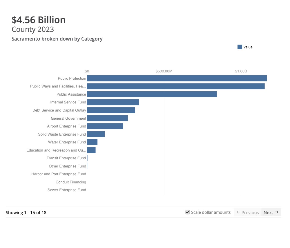
Two other types of tax which are progressive, meaning that high-income people pay a higher percentage of income than low-income people, are income tax and property tax. Income tax does fund transportation at the state level, but income taxes are not available to cities, counties, and special districts. Property tax can fund transportation, though due to Prop 13 which limits property tax, it mostly goes to schools and public safety. For Sacramento County in 2023, the chart below shows allocations. The ‘Public Ways and Facilities, Health, and Sanitation’ category goes mostly to Health, with Public Ways and Facilities being less than 20% of that category. This chart does not include school districts within the county, which also rely on property tax.
Transfer taxes, which are based on the value of a property when it is sold, are progressive. These have been discussed in a number of places in California, though not locally so far as I have heard. I am not aware of any existing transfer taxes that fund transportation, though they do fund a number of other government functions. The state levies a transfer tax throughout the state, and that income goes into the general fund.
Any county, city or special district can bond against property tax, meaning that they can expend money now and pay it back over time from future property tax income. Again, Prop 13 limits the usefulness of this by suppressing property tax income, but does not preclude it. If Prop 5 on the 2024 ballot passes, cities, counties, and special districts will be able pass bond measures with a 55% vote rather than 2/3 vote, though the proposition raises the bar on transparency and types of expenditures. Though Prop 5 is intended primarily to fund housing, it could fund transportation, and there is a logical nexus with transportation that supports housing.
For other posts on transportation funding, see category Transportation Funding.
this week 2024-11-04
SacMoves Coalition hosts an event calendar at https://sacmoves.org/events/, which is maintained by STAR (Sacramento Transit Advocates and Riders) and Getting Around Sacramento.
Monday 04
- Sacramento Climate Coalition, 6:00 PM, To participate in this monthly meeting, please email info@sacclimate.org to be added to the list.
Tuesday 05
- Election Day, as though you haven’t already voted
Wednesday 06
- County Board of Supervisors, 2:00 PM, agenda 2: Adoption of Communitywide Climate Action Plan
- SacRT SmartRide workshop, 5:30 PM, online
Thursday 07
- SACOG Transportation Committee, 10:00 AM, SACOG, 1415 L Street, Suite 300, Sacramento, CA 95814
- Strong SacTown monthly meeting, 6:00 PM, Grounded Real Estate, 915 20th St, Sacramento, CA 95811
Friday 18
Saturday 19
- SacTRU (Sacramento Transit Riders Union) month meeting, 1:00 PM, online
Sunday
SacCity mayoral candidates on transportation
I don’t know anyone who hasn’t already voted, but information about the City of Sacramento mayoral candidates, Flo Cofer and Kevin McCarty, will be valuable beyond the election. SABA (Sacramento Area Bicycle Advocates) sent in a Gear’d Up email a compilation of candidate positions and perspective on transportation, which I’ve copied below.
| Sacramento Mayoral Candidates on Transportation and the Environment SABA is taking a look at the stances of the two Sacramento mayoral candidates – Dr. Flojaune Cofer and Assemblyman Kevin McCarty – related to environmental issues. While we understand that there are many important issues facing Sacramento, especially with regard to the unhoused population, our focus here is on issues related to transportation and the climate crisis. The views presented here are taken from forums conducted by the League of Women Voters, the Sacramento Bee, and KCRA 3. |
 Dr. Flojuane Cofer is an epidemiologist, policy director, and advocate for change. She worked at the California Department of Public Health and then as a Senior Policy Director at Public Health Advocate. Cofer served on Sacramento’s Active Transportation Commission, Mayor’s Commission on Climate Change, Sacramento County Sheriff’s Outreach Community Advisory Board, and the Measure U Community Advisory Commission. Dr. Flojuane Cofer is an epidemiologist, policy director, and advocate for change. She worked at the California Department of Public Health and then as a Senior Policy Director at Public Health Advocate. Cofer served on Sacramento’s Active Transportation Commission, Mayor’s Commission on Climate Change, Sacramento County Sheriff’s Outreach Community Advisory Board, and the Measure U Community Advisory Commission. |
 Since 2014, Kevin McCarty has served as Sacramento’s Assembly member – representing the 6th Assembly District. McCarty serves as Chair of the Assembly Public Safety Committee. From 2014 to 2023, he served as the Chair of the Assembly Budget Subcommittee on Education Finance. A lifelong Sacramentan, McCarty began his career as a Housing and Redevelopment Commissioner, and then served on the Sacramento City Council for a decade. Since 2014, Kevin McCarty has served as Sacramento’s Assembly member – representing the 6th Assembly District. McCarty serves as Chair of the Assembly Public Safety Committee. From 2014 to 2023, he served as the Chair of the Assembly Budget Subcommittee on Education Finance. A lifelong Sacramentan, McCarty began his career as a Housing and Redevelopment Commissioner, and then served on the Sacramento City Council for a decade. |
| SABA does not endorse either candidate. (Disclosure: Cofer is a member of SABA and McCarty has lent financial support to a project that will launch in 2025.) |
| Here’s where they stand on the issues: Climate Action & Adaptation Plan, which includes a greenhouse gas reduction target for 2030 and a carbon neutrality goal for 2045. Cofer: As a commissioner on the Mayor’s Climate Commission, Cofer helped develop Sacramento’s Climate Action Plan and would like to move the dates up to accomplish carbon neutrality sooner. As mayor she would commit to setting priorities for the city council and plan how the city can take on more to achieve climate goals sooner. McCarty: He would like to achieve the goals that were set out in the plan and figure out how to pull down resources from the state and federal governments. When the city was in a budget crisis, he found resources to support city services like the firefighters and would do the same for the Climate Action Plan. Funding for the Climate Action & Adaptation Plan Including Proposed 2026 Sales Tax (the Plan is budgeted at over $3 billion) Cofer: She believes we need to look at the Plan and figure out how to implement it; set a goal and figure out where to start; and decide on the major investments we need to make now to save money down the line and yield us dividends. Cofer says we should look at matching funds from the state and federal government, as well as local partnerships. She believes neighborhood associations, unions, nonprofits and businesses will step up and that we should see them as partners rather than adversaries. The public was frustrated that the sales tax from 2019 was not spent on homelessness, affordable housing and the arts, and Cofer says we need to build trust with the voters by righting things before going and asking for more money; and we also shouldn’t impose a tax on people with lower incomes. McCarty: He wants to look at opportunities to leverage funding for state efforts. McCarty says the State of California is our largest employer and landowner and we need them to step up to help us achieve our climate goals. Voters are very frustrated that things aren’t getting done and McCarty believes we have to restore confidence in city leadership to pass traditional revenue. He says the sales tax is regressive and that people of lower income are disproportionately impacted by climate and should not bear disproportionate burden. Commitments to Climate Initiatives Cofer: She believes we need new leadership. Cofer has built coalitions and served on five different boards, committees, and coalitions. In the first 100 days, she commits to 1) set priorities for the city of Sacramento that include our climate goals and take action every year. 2) Make sure we have a standing committee on climate where we have community members helping us to figure out new innovative solutions. McCarty: His top two initiatives are to promote active transportation and build more infill housing. Public Transit & Active Transportation Cofer: She supported a resolution to expand transit and make it free for kids K-12. She believes the best way to expand transit is to provide it at low or no cost and wants to get young people to ride so they become lifelong transit riders. Cofer wants to expand free rides to college students and to make public transit accessible for disabled and older people. She would like to see it kept running for major events – make it convenient and useful for everyone, not just low-income people.Cofer served on the Active Transportation Commission because she is an avid bike rider and has been hit by a car. She wants to implement design features to make it safer for people to bike and walk. When there is new construction, Cofer wants to make bikes and pedestrians a priority to signal that safety is paramount. McCarty: When he lived in Boston, McCarty took public transportation everywhere, but Sacramento’s transit system isn’t as comprehensive. McCarty believes we need more routes and frequency, and to look at land use so people can live closer to the things they need and won’t always need to drive. He believes our transportation infrastructure prioritizes cars. As a medical consultant for a school district, McCarty tried to get kids to walk more. He says there’s a need to make walking safer by not having people camping on sidewalks and by addressing other public safety issues. Cycling and Pedestrian Safety Cofer: She acknowledges that traffic is the number one cause of fatalities and serious injuries. Cofer wants to invest money to draw matches at the state and federal level. She says traffic safety should be proactive. McCarty: He believes that roads should be fixed to proactively eliminate deaths. He would like to improve bike and pedestrian infrastructure across Sacramento, not just midtown. McCarty acknowledges that there is an equity issue – some people ride by choice; some don’t have another option. Sprawl and Urban Development & Downtown Revitalization Cofer: One of the things in the CAAP is prioritizing infill development. Cofer wants to develop housing and build near existing infrastructure to not increase emissions. As someone who served on the Climate commission, she doesn’t want to start building in places where we already have trouble with transit. She believes we need to start building in places where we already have rail and bus lines and not create another car-centric community. Cofer doesn’t want to offer downtown properties to developers “for free.” She would like to use adaptive re-use for example, bringing Sacramento State downtown. Cofer says downtown needs to be an entertainment hub. She believes that bringing state workers back to the office is not the way – it goes against our climate goals. McCarty: He says we have a housing shortage and we have people coming to Sacramento. McCarty believes we’re not going to end sprawl by simply limiting construction within the city; we can’t control what happens across another border. He says we need to facilitate infill development and that telework is here to stay. 45% of downtown property is state or federally owned and they pay zero property tax. McCarty would like to instead, put that property in private hands such as housing, entertainment, restaurants. He wants to work with Sacramento State to bring student housing downtown. |
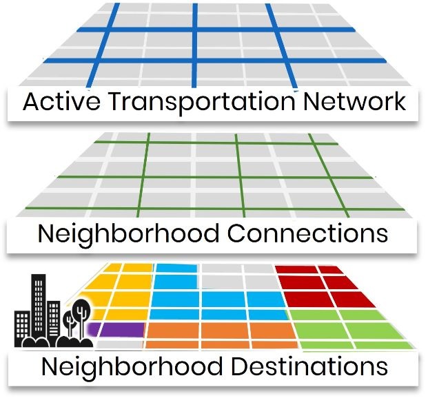
SacCity Neighborhood Connections workshops
The City of Sacramento is holding two online workshops on the Neighborhood Connections portion of the Streets For All Active Transportation Plan, on Wednesday, November 13 at 6:00 PM, and Wednesday, November 20 at 12:00 noon. Registration is available on the Streets for People webpage. The Neighborhood Connections Public Draft Plan will be available on November 4 on the Streets for People webpage.
The Neighborhood Connections Story Board is the most valuable document to come out of the project so far, well worth a look. I’ve written about traffic calming features in Neighborhood Connections before, as well as other topics in Streets for People and Street Design Standards. There is a great deal of overlap, and should be, between the Streets for People Active Transportation Plan and the Street Design Standards Amendment.
“The Neighborhood Connections Network is made up of residential streets and minor collectors that connect to neighborhood destinations, such as parks and retail. The network includes proposed traffic-calming treatments to reduce vehicle speeds and volumes to support people walking, biking, and rolling.”

SacCity parking revisions
The City of Sacramento is undertaking revisions to parking requirements for private motor vehicles and bicycles, as directed by council and the 2040 General Plan.
The draft parking strategy is available for review, as a document review webpage, and here as pdf.
Two online meetings are being held, Wednesday, November 13 at 10:00 AM, and Thursday, November 14 at 5:30 PM. Registration is required, and available on the city Parking Revisions webpage. You can also email the city, address on the webpage.
The city removed parking mandates in the central city in 2013, and within 1/4 mile of transit in 2019, and state law now prohibits mandates within 1/2 mile of ‘major transit stops’.
I have not had a chance to review, so don’t have any comments at this time.

SacCounty Climate Action Plan, November 6
Adoption of the Sacramento County Community Climate Action Plan is item 2 on the Sacramento County Board of Supervisors meeting on Wednesday, November 6, at 2:00 PM. I have not been following the Sacramento County CAP, as it is beyond my capacity, but several organizations have, and they are opposed to the plan under consideration. To summarize, the county has created a plan that won’t stand in the way of low density development at the edge of and beyond the county growth boundary. Translation: sprawl!
The best reference I’ve found is an email from 350Sacramento, so this is duplicated below.
“Tell supervisors: Don’t Approve
In 2011 Sac County promised to adopt a climate action plan (CAP), “within a year”. We’ve pushed them hard for five years to do that, and critiqued five technically and legally insufficient drafts. The problem is that the County is committed to approving several very large, high-GHG, sprawl developments outside the County’s growth boundary, and an effective CAP would get in the way.
This Wednesday the County will try to steam-roll us, adopting a final CAP with the same deficiencies as before, claiming the CAP isn’t subject to environmental requirements. We’re not buying it… Please click and send a pre-written email to County supervisors.
We’re making legal points, but feel free to substitute or add your own thoughts and feelings. Think of pointing out that elected officials are irresponsibly embracing land speculators and sprawl over protecting our environment.
All this proposed sprawl would do nothing to solve the housing crises: The County has already approved over a 100 years-worth of growth in infill and new projects. With the new sprawl they will have adopted almost 200-years of growth capacity. That won’t build-out in anyone’s lifetime; but it will start to build-out as small tracts scatter across the County – the worst possible land use for climate stabilization.
Make your voice heard and share this issue with others in your network!”
