no grid: the original sin of city planning

The oldest parts of the City of Sacramento have a grid street pattern, meaning streets and cross-streets at regular intervals. Nearly all of the central city and much of east Sacramento have a grid. Outside that, there is a broken grid, or no grid. There are certainly constraints to a grid, such as the Sacramento River and American River, railroad tracks, and old highways that are now arterial streets, such as Stockton Blvd. And of course there are the freeways that have destroyed what grid did exist: Interstate 5, Interstate 80, Highway 99, Highway 50, cutting most local streets into two inaccessible sections.

I acknowledge that the other cities of Sacramento County, and unincorporated county, are as bad or worse than anything in the city, but I’m using the City of Sacramento as a example of a universal problem in the region. In the eastern suburbs, unincorporated Arden-Arcade, Carmichael, Fair Oaks and Orangevale, streets intentionally change directions, for example, a street that starts out north-south will end up exiting east-west to an arterial. Other streets loop back on themselves, but change names somewhere along the way. Streets that were designed wide, as through streets, suddenly end. Yes, things can be much worse.

Here is the central city grid. Not perfect, but close.
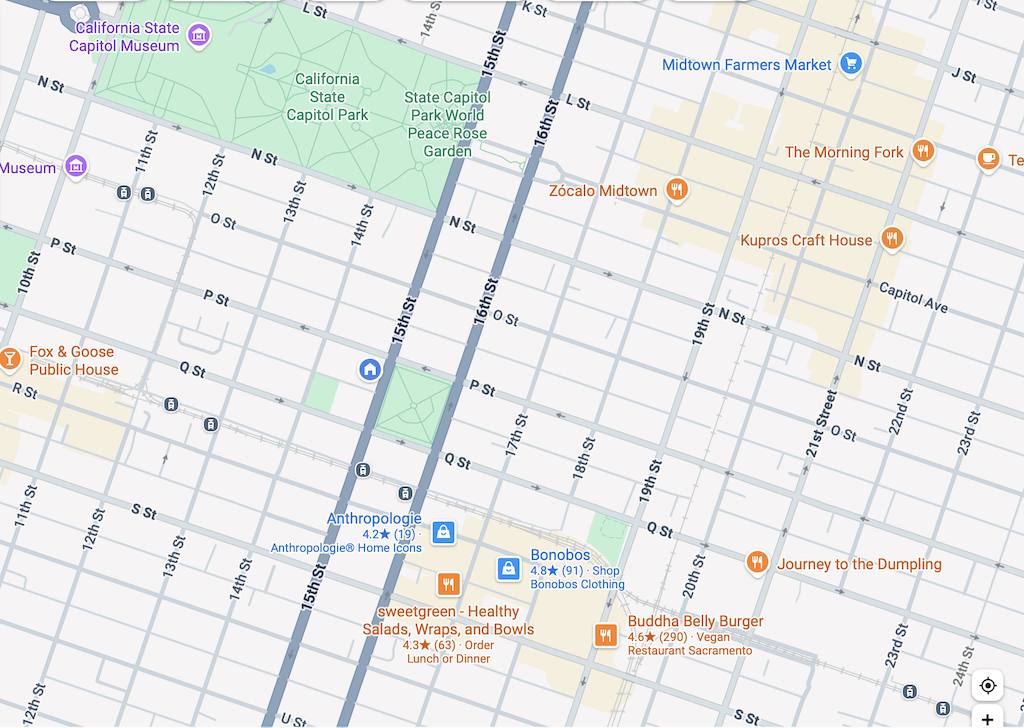
Sacramento central city grid, Google Mapsh
Sacramento central city grid, Google Maps

Here is East Sacramento. Less regular, but not bad.
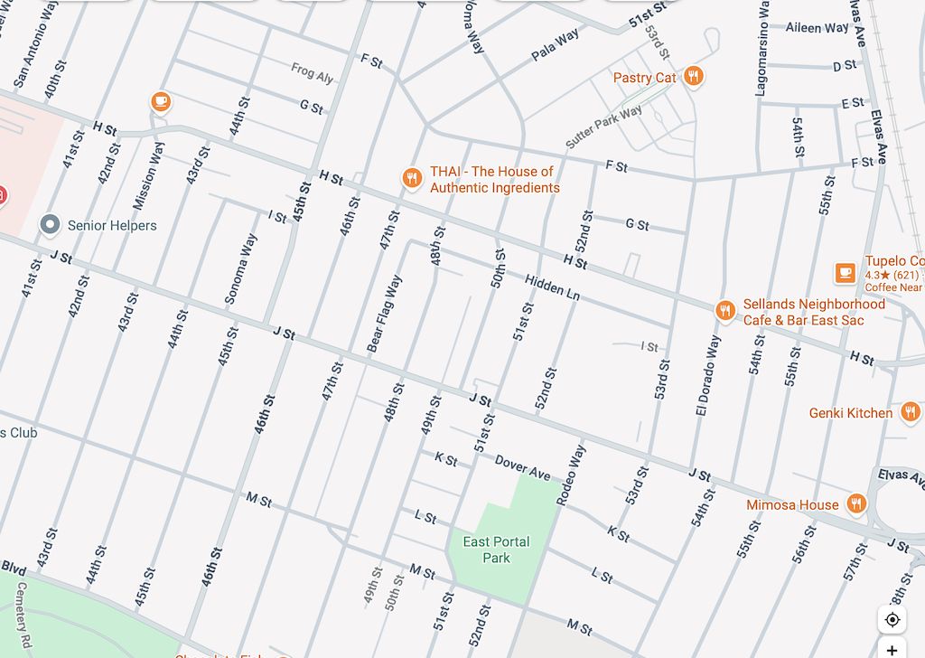
Sacramento, East Sacramento grid, Google Maps

Here is a section in south Sacramento. There are grid streets, Florin Road, Meadowview Road, Freeport Blvd, and 24th Street. There are even a through street within this section, 21st Street. But none of the other streets are through streets. Some are straight, and some wind around.
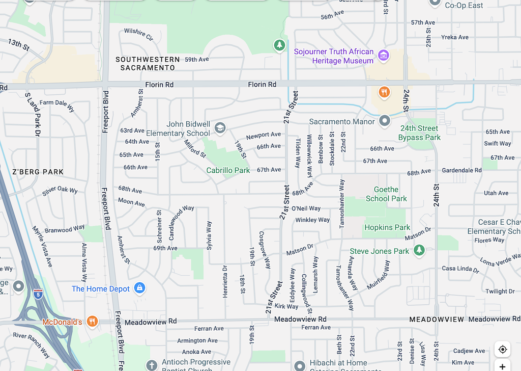
Sacramento, south Sacramento broken grid, Google Maps

And finally, here is the River Lake area of The Pocket. Few through streets, cul-de-sacs everywhere. No way to get from one area to the next.
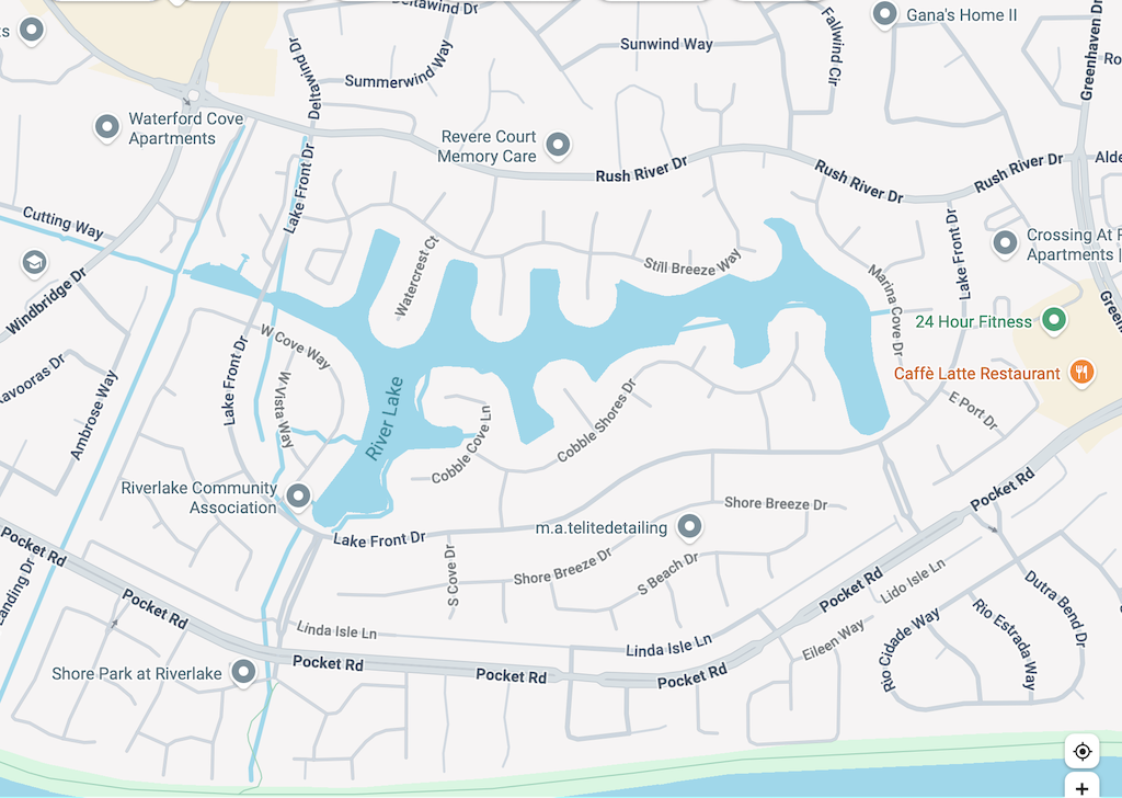
Sacramento River Lake, no grid whatsoever, Google Maps

So why is this important? Grids allow travel by many different routes. They allow travel on parallel streets so that some streets can emphasize car travel (well, actually, all of them do, currently), while others are or could be for slower travel by foot and bicycle. Grids allow efficient bus routes that get people to destinations with no transfers or one transfer. Our bus system that exists is a maze of zig-zags, largely trying to make the best of a no-grid street system.

Why did this happen? In the Sacramento area, developers of high income neighborhoods (see River Lake above) wanted windy streets so that only people who live there can figure out how to get places. Cul-de-sacs galore, making sure that people from outside (‘those people’) cannot get into the neighborhood, and guaranteeing low traffic on that street, while increasing traffic on all other streets as people try to get somewhere. In middle income neighborhoods (see South Sacramento above), windy streets were designed to give the feel of a high income neighborhood. If you can’t figure out where to go, isn’t that a sign of income?

Broken grid and no-grid neighborhoods make sure that amenities such as groceries, coffee shops, and medical services, are further away. Everyone must drive. All traffic must be funneled onto larger and larger, and more dangerous streets. And isn’t that the point of these neighborhoods, a sign of wealth when you can have the fancy car that exceeds the cost of some homes, and a deep bank account for gas, or charging?

Downtown Sacramento had most of its buildings removed, replaced by state buildings and massive buildings, which is why downtown is largely dead. But the street grid is mostly still there, the bones of what could someday become a livable, functional place again. As I have said many times, midtown Sacramento is the model of what a place can be, a vibrant neighborhood with a mix of uses. The grid is in large part what allowed it to develop, and to continue to exist. I doubt that most of Sacramento will ever evolve to a more economically vibrant and livable place. Without a grid street network, it can’t.

Many people have argued that single family homes, exclusionary zoning and redlining, and suburban sprawl are the original sin. They are a sin, but not the original sin. The original sin is the lack of a grid street system.

The city allowed this, by allowing developers to design any sort of street pattern they wanted. The city could have developed a grid street system, and allowed developers to design streets within this, but they did not. They also did not require that streets in one development connect to streets in an adjacent development. The lack of a grid is a problem that will haunt us forever. But for any new development areas, the city must design and enforce a street grid. Regular north-south and east-west streets should be on a grid of one-quarter mile. Within that grid, developers can do what they want, but they can’t break the grid.

The street grid is a topic that crosses boundaries (ha ha) between street design standards (Public Works, Street Design Standards Amendment) and development standards (Community Development, Planning Division). I am not sure where it best belongs, but I do know that it must exist, and must be enforced, no matter what bribes (mostly in the past) or campaign contributions (modern bribes) are made.

The lack of a grid has long bothered me, but I’m posting about it now because the recent How to design for cars in people-centred places suggests that not every street needs to be multi-modal, that a ‘complete network’ of parallel routes, rather than a ‘complete street’ is a better solution, hence “Complete networks, not complete streets”. I have just started to look at the design guide, but this is something that jumped out at me in the Strong Town podcast and Streetsblog post – how do you have parallel routes when there are no parallel streets, because there is no street grid?

More to come.

the future of downtown

The Belote Lecture: “The Future of Downtowns: Developing a New Vision for America’s Urban Core” occurred on Tuesday at the Citizen Hotel, sponsored by McGeorge School of Law. Chris Morfas alerted me to the lecture by re-tweeting Greg Shill, who I’ve always wanted to meet.

Brian Schoenfisch of the City of San Diego talked about how they had activated public space downtown by closing streets, liberal implementation of temporary and permanent use for dining and recreation, and new parks. Almost all development in downtown is by-right, which was accomplished by removing regulations and doing a categorical CEQA approval for downtown infill.

Noah Arroyo of the SF Chronicle said that a lot of the homeless issue in SF was more perception that reality. He also said that the many, many layers of development review in SF make it nearly impossible to build affordable housing, or any housing.

Greg Shill of University of Iowa Law School said we need to change cities so people can walk/bike to destinations, that cities actually have a lot of control over what happens there, and that transit is going to be in crisis for at least ten years.

Cornelius Burke of California Building Industry Association said that we need housing of all types and for all income levels.

Questions from the audience largely focused on how we make up for past mistakes like urban renewal and redlining, and how citizens can ensure movement towards building cities people want. Everyone agreed that creating a more successful Downtown Sacramento requires housing, housing, housing, to replace and grow beyond that which the city and state removed during urban renewal.

I had interesting discussions with Greg Shill before and after, and with Brian Schoenfisch after. I think the real benefit of these presentations is the opportunity to bounce ideas and perspectives off of people who have spent a lot of time thinking about these issues.

As I was listening to the lecture and questions, I was also looking out over downtown from the 7th floor Metropolitan Terrace, I came back even more strongly to a key difference between successful midtown and struggling downtown. Almost all of the existing developments and opportunities downtown are quarter block, half blocks, and full blocks. The fine-grained parcels of midtown, which allow and encourage infill development, were erased by the city when they acquired the small parcels and aggregated them into large parcels. So now there are only opportunities for big developments, and big developments are even harder now than they were before. If the city really wanted to promote infill, they would break up the large parcels that are empty or hold surface parking lots into smaller parcels. Infill developers would be asking for these opportunities. Almost no one is asking for the large parcels.

Unlike many events I go to sponsored by the Downtown Sacramento Partnership, at this one I did not know anyone else. That is actually fun, meeting new people.

Vacant buildings

I find it interesting when something I’ve been thinking about but not written about suddenly shows up in Twitter and news media. Specifically, vacant buildings. Not talking about buildings that have been vacated during the pandemic, which may or may not see future use, but buildings that were vacant pre-pandemic, oftentime for years. The Sacramento central city has a lot of vacant buildings, most of them commercial spaces such as offices and warehouses, but some housing and retail as well.

The CityLab article The Case for a Duty to the City raises the issue and possible solutions to empty and underutilized buildings. It was highlighted in a Strong Towns UpZoned podcast “If you have a property in the city, you should not leave it empty.”, which brought me to it. And then today an article in the Sacramento Business Journal Cassadyne plans 50-unit apartment project in Midtown Sacramento (sorry about the firewall), about replacing empty parking lot with housing and an unused warehouse with parking.

I don’t have a solution for unused/underused/vacant buildings. Certainly the city should do everything it can to encourage adaptive reuse of functional buildings, or replacement when the building is no longer functional or can’t be repurposed for any use that is economically viable. But I’m also mostly a libertarian about property use, believing that people should do what they want with their property (while still not believing in the whole concept of private property). So I don’t think the city should force any particular development or use on a property owner, but sending economic signals that letting a building sit vacant is not in the best interest of the city, that is a valid function of a city.

Vacancy taxes or fees are one of the actions that has been proposed in other cities, particularly cities in Europe. I have mixed feelings. These might turn a project that is barely viable for a property owner into a decision to sell the land to a bigger developer who might be even less likely to move forward with productive use. So if there were to be a vacancy tax in Sacramento, I’d want an exclusion for any property that is owned by an individual rather than a corporation, or properties that are only a single traditional parcel (that has not been aggregated into a large parcel). That might actually encourage corporations to shed their small properties back to the market, so they could be picked up by smaller infill developers. More about small versus large developers, and preservation of traditional parcels, in a future posts.

Not knowing much specifically about this development proposal, I tend to think that the developer is providing too much parking, which will be underutilized, and which will promote vehicle ownership and use. But… I don’t think the city should prohibit that. It should, however, send a message that unproductive uses such as unneeded parking will have a cost, some sort of tax or fee on land used as parking. Or requiring that parking be unbundled from rent. Or requiring that the parking be available to the public through metering. Some policy that sends a message that excess parking is a societal harm rather than something to be promoted.

1500 S St infill

The house at 1500 S Street, and commercial building at 1506/1508 S Street, have been razed in preparation for a new development.

1500/1506/1508 S St, Sacramento

I am curious about redevelopment/infill projects in the central city because they have the potential to increase housing, allowing more people to live in the central city, improving economic vibrancy for businesses and property/sales tax for the government. At the same time, I know that perfectly viable Victorian houses have been torn down for redevelopment, so I’m not always in favor of these projects.

The house at 1500 S Street had been unoccupied for years. Same with the commercial building at 1506/1508 S Street. Houses on three adjacent lots were razed sometime between July 2015 and February 2018. As much detail as I was able to gather from Zillow and Google Earth historical imagery is below. I think it is interesting that the houses had survived for 95 years, 103 years, 101 years, and 108 years, whereas the commercial building lasted at most 36 years. So many commercial building are disposable, often not built to last, and not worth modifying or reconstructing. The house on the corner, 1500 S Street, looked to be in poor condition. I don’t know about the other three houses.

  • 1500 S St, house 926 sf, lot 3200 sf, 1926, gone 02/2021
  • 1506/1508 S St, building, built after 12/1985, gone 02/2021
  • 1512 S St, 3,129 sf, lot 6400 sf, 1915, present 7/2015, gone 5/2018
  • 1516 S St, 1,177 sf, lot 6400 sf, 1915, present 7/2015, gone 7/2016
  • 1522 S St, 876 sf, lot 6400 sf, 1910, present 7/2015, gone 2/2018

The combined lots sold for $5,125,000 in 2019.

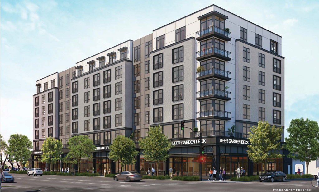
The information I was able to find about plans for the location are: Anthem Acquires an Infill Project in Sacramento, Anthem Properties submits plan for site near R Street Corridor (2020-04-27, firewalled), and Downtown Sacramento Partnership 1500 S, all indicating a mixed use building of eight stories.

1500 S Street, from SacBiz

Sac Opportunity Zones

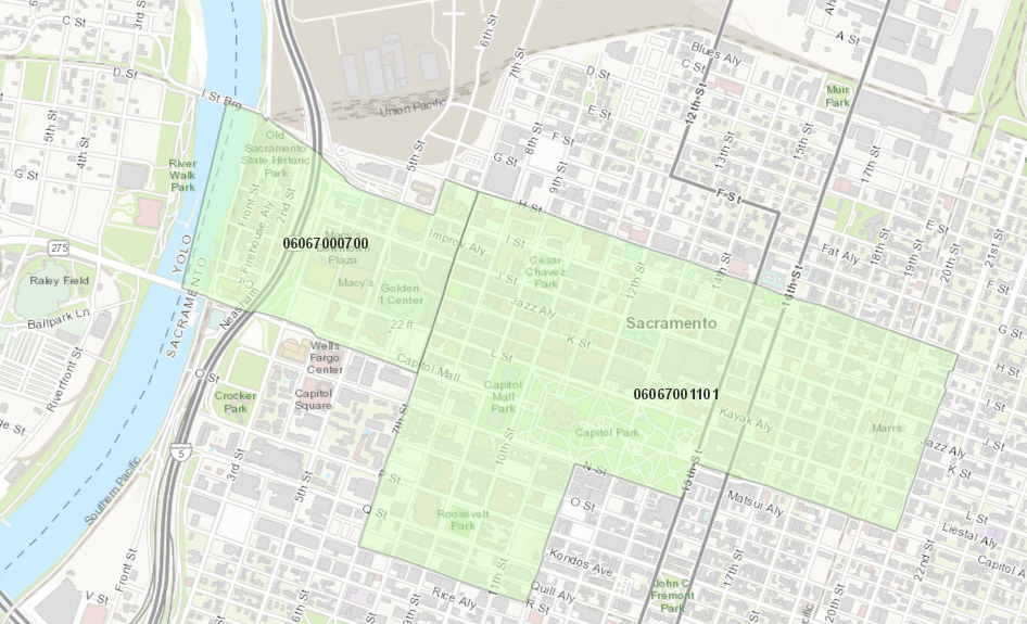
Opportunity Zones are something I’ve never paid much attention to, and don’t understand very well, so what follows is just information from a new report, National Opportunity Zones Ranking Report, by LOCUS and Smart Growth America. The report selects two of the 46 designated opportunity zones/census tracts in the county for ranking, 06067000700, western downtown, and 06067001101, eastern downtown and midtown, as shown on the map.

On the  ‘Top Opportunity Zones for Smart Growth Potential’ list, 0700 is in the ranking 3 band (of 6), and 0101 is in the ranking 4 band. On the ‘Top Social Equity and Vulnerable Places with High Smart Growth Potential’ list, 0700 is ranked 6 of 50, but 0101 is not on the list. On the ‘Top Opportunity Zones Markets for Office Asking Rents’ list, Sacramento is ranked 8 of 10, but it isn’t clear whether this is one or both census tracts. On the ‘Top Opportunity Zones for Office Asking Rents’ list, the two Sacramento tracts are ranked 47 and 47, with asking rents of $31.14 per square foot. On the ‘State (Top 10) Opportunity Zone Snapshots’ list for California, Sacramento 0700 is ranked 3 in the whole state.

What does this all mean? Well, I’m not sure. I hope that other people will chime in. I do note the following things:

  • The emphasis for Sacramento is on office space. I don’t think that is a good measure of a livable city, particularly one whose downtown is already overwhelmed by state offices. What downtown needs is people, not offices. But if the investment opportunity is in offices, that is what we will get.
  • The population of western downtown, 06067000700, is small, 2798 in 2012, and for 06067001101, 2082, though because it is much smaller 0700 has a population density of 13,990/sqmi while 1101 is only 3,413/sqmi.
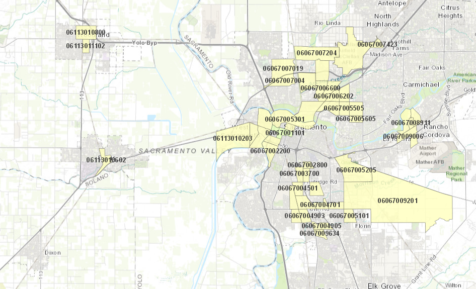
  • Why do the other 44 opportunity zones in Sacramento county not show up? It could be because the have less opportunity for smart growth investment, or it could be because they have significant challenges on the SEVI (Social Equity + Social Vulnerability) scale. I’m not sure. See all the Sacramento region Opportunity Zones on the map below.

There is an interesting opinion article in the SacBee California Forum from May: Sacramento has its best shot in years at outside investment. Seize the opportunity. California has an interesting website at https://opzones.ca.gov/, but it doesn’t really answer my questions either.

Driving a stake through LOS

The Governor’s Office of Planning and Research has completed the first step in replacing level of service (LOS) with vehicle miles traveled (VMT) as the primary measurement for determining the CEQA impact of development on roadways by drafting the replacement language. This process was specified in In the second step, the Natural Resources Agency is holding a public process to implement the changes, and you can participate. Two meetings have been scheduled:

Sacramento
Date: March 15, 2018
Time: 1:30-4:30pm
Location: California Energy Commission, Rosenfeld Hearing Room
1516 9th Street, Sacramento, CA 95814

Los Angeles
Date: March 14, 2018
Time: 1:30-4:30pm
Location: California Science Center, Annenberg Building, Muses Room
700 Exposition Park Dr, Los Angeles, CA 90037

You can also comment by email at CEQA.Guidelines@resources.ca.gov.

I hope that you will support the changes either in person or by email. The use of LOS has caused incalculable damage to roadways and to livability throughout California. CEQA, originally intended to protect the environment, as been used instead as a weapon to harm the environment and encourage sprawl. Urban infill could rarely meet the requirements of LOS in CEQA, but suburban development almost always could, so what we got is square miles of suburban and exurban sprawl, and very little infill. This change to VMT will at least level the playing field, and may make sprawl more difficult. I don’t know how much opposition there will be, but there are several interests that would like thing to stay just the way they are: engineers who want to build highways instead of transportation systems, greenfield developers who make huge profits while shifting costs to society, and cities and counties (you, Sacramento county, and others) who want to preserve their ability to encourage and subsidize far-flung development. If you like cities, if you like livability, if you like infill, this is one of the most important things that can happen.

Of course, this is only the second step in driving a stake through the heart of LOS. The third step is to ensure that all cities, counties, and regional agencies remove LOS as a tool in planning development and transportation. The legislation and these regulations will prevent exclusive use of LOS by any entity, but it does not preclude use of LOS as a additional criteria. LOS must be eliminated completely. The most important question in transportation and development is what kind of world we want to live in, and though VMT is only a tool for achieving that, it is far far better than the tools we currently use.

For all the details of the Natural Resources Agency process and regulation, see the CEQA page and the notice of rulemaking.

#JustSayNoToAmazon

Within hours of Amazon announcing a competition to create a second headquarters, HQ2, mayors and governors all over the country were saying “Me, me, choose me.” Including Sacramento Mayor Darrell Steinberg. This is a mistake!

I don’t have anything against Amazon, they are a company with a business model that has been remarkably sucessful. I shop there, at least when I can’t easily find an item locally. Their prices are often remarkable. Yes, and I also feel hesitant or guilty each time. But this isn’t about Amazon.

I’m also not against jobs. And I’m also not against development, though I certainly prefer small-scale development to large-scale development. A headquarters with 50,000 employees is something that would overwhelm all but the very largest cities. Sacramento is not among those cities. 

What this is about is about a city (and regional and state) economic model that says we can’t get anything good unless we soak the taxpayers for a subsidy. In this case, Amazon is asking for a huge subsidy from whatever locale “wins” the competition. 

On the positive, Amazon includes the requirement: “Direct access to rail, train, subway/metro, bus routes”. But they also seem quite willing to be in the suburbs, on a greenfield site, only asking within 30 miles of the city center. In the case of Sacramento, that includes Davis, El Dorado Hills, Roseville. Ack!

The RFP then gets to the heart of the matter, money!

Capital and Operating Costs – A stable and business-friendly environment and tax structure will be high-priority considerations for the Project. Incentives offered by the state/province and local communities to offset initial capital outlay and ongoing operational costs will be significant factors in the decision-making process. 

Incentives – Identify incentive programs available for the Project at the state/province and local levels. Outline the type of incentive (i.e. land, site preparation, tax credits/exemptions, relocation grants, workforce grants, utility incentives/grants, permitting, and fee reductions) and the amount. The initial cost and ongoing cost of doing business are critical decision drivers.

In other words, we will consider you if you come up with a bigger bribe than anyone else. I doubt that Sacramento can compete in this arena, but more to the point, no one should be in this competition. Amazon is a very successful company. They don’t need our subsidy to be successful.

So, back to the title #JustSayNoToAmazon. I’m not suggesting that Sacramento decline on its own. I’m suggesting that big city mayors show some true leadership, meet with each other, and, as a unified whole, decline the Amazon offer. This is a chance for Mayor Steinberg to show some real leadership and not just be a booster for failed economic models. 

Articles and posts on the Amazon plan are proliferating, but let me suggest two: