Crash Rapid Response Program for SacCity

Note: This post has been significantly revised and published as two separate posts, one on OakDOT’s Rapid Response Program, and the second a proposal for a City of Sacramento program.

When a fatality or severe injury for walkers and bicyclists, people often ask, what can we do right now to prevent or reduce the severity of the next crash? This topic has come up a number of times at the Sacramento Active Transportation Commission (SacATC), and communication by Slow Down Sacramento, Civic Thread, SABA, and other organizations. I believe now is the time for the City of Sacramento to establish and fund a crash rapid response program.

OakDOT Rapid Response Program

The City of Oakland Department of Transportation (OakDOT) seems to have the best program I could find on the Internet. This is not surprising – since being formed in 2016, OakDOT has led on developing programs for safer streets that are informed by equity. So far I have not found a single document that describes the program and procedures, so I’ve selected some information from the Safe Oakland Streets (SOS) and related pages and documents. Safe Oakland Streets is Oakland’s version of Vision Zero.

Rapid Response Projects: OakDOT seeks to eliminate traffic fatalities and severe injuries while promoting safe, healthy, equitable mobility for all. OakDOT’s efforts to make streets safe include rapid responses to fatal and severe crashes involving the most vulnerable users of Oakland’s roadways. A Rapid Response is a coordinated effort in the days and weeks following a traffic tragedy that may include investigations, targeted maintenance, near-term improvements, and the identification and prioritization of longer-term capital needs.”

“A Rapid Response may be activated for traffic crashes resulting in pedestrian or bicyclist fatalities, or severe injuries to pedestrians or bicyclists who are youth or seniors. A Rapid Response may be activated for additional crashes based on the individual circumstances of a crash.”

The two elements most relevant to rapid response are:

  1. Maintenance Treatment: If the crash location has a maintenance issue that may be related to traffic safety e.g., pavement defect, faded striping, missing sign), the maintenance issue will be rectified by field staff.
  2. Quick-Build Improvement: If there are design treatments that could be implemented quickly at low cost, engineering staff will prepare the design and issue a work order for field staff to construct.

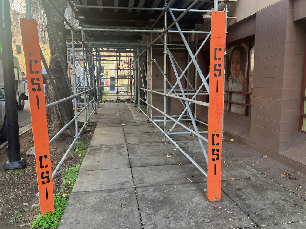
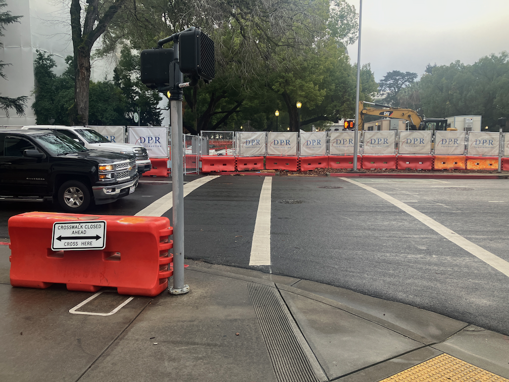
The following photos shows the setting after rapid response to a fatality that occurred at Harrison & 23rd. See Harrison & 23rd St Crash Response for more information.

photo of OakDOT rapid response project at Harrison & 23rd

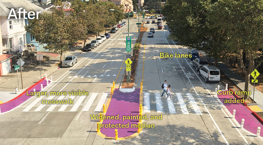
OakDOT has a Crash Prevention Toolkit with photos of solutions, most of which are inexpensive and quick to implement.

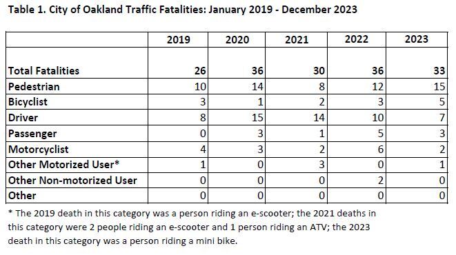
OakDOT offers a map with locations of fatality crashes and relevant features such as high injury network and equity, Traffic Fatalities, City of Oakland. A chart, below, also shows yearly data for modes of travel. A Crash Analysis Infographic also communicates data visually.

OakDOT chart of traffic fatalities by mode over time

SacCity program outline

The city program should start small to make sure that there are sufficient resources of staff time and funding to do a good job. I would suggest in the first year responding only to crashes on the high injury network. Yes, those will get fixed with grants, but those are very long term projects, whereas quick fixes are also needed. An alternative would be to do only fatalities, not severe injury crashes.

A rapid response team should be composed of at least three people. One must be a traffic engineer. Others could be planners, law enforcement, and a member of an advocacy organization (Civic Thread for walkers and SABA for bicyclists). Though the participation of law enforcement may not be useful to the outcome, it is useful for educating police about street design.

It is important that the team review existing documentation and make a site visit. The full law enforcement incident report will not be available within the rapid response time frame, but sufficient detail should be available to determine the movements of the people involved in the crash.

The team should make a report within five working days of the crash, listing obvious and inexpensive fixes, prioritized by effectiveness. One or more of the fixes should be implemented within 20 working days of the crash.

Public Works staff should report to SacATC on a yearly basis on the rapid response program, the projects undertaken, staff time, and money spent. After the first year, this information should be used to develop a budget request for future years.

City of Sacramento should create a fatalities map similar to Oakland’s, with frequent updates, from SacPD information. The state SWITRS database always lags too far to be useful.

A dashboard should be developed that includes fatalities and severe injuries by type of mode and trends. SacATC has already requested a dashboard that would also show projects applied for, in progress, and complete.

As with any new program, this one would and should evolve as experience is gained and the public sees the value of the program in reducing or eliminating fatalities.

SacCity Council save the date for General Plan adoption

Adoption of the 2040 General Plan will likely be on the Sacramento Council on Tuesday, February 27, one month from now. Though the plan could be even better, and its success will depend on a number of documents to be finished after adoption, this is an innovative and forward-looking document, much better than the last one. I hope that you will speak in favor of adoption at this meeting. The Climate Action and Adaptation Plan, developed separately but supposed consistent with the general plan, will be adopted at the same time. The concepts of the Missing Middle Housing Project are also largely contained in the general plan. The documents that will be developed later include Streets for People Active Transportation Plan, Parking Management Plan, and Street Design Standards, and many others.

My previous posts on the 2040 General Plan are available in category ‘General Plan 2040‘.

Save the date – put it on your calendar now! It will likely be a 5:00PM meeting, though when the General Plan comes up for comment depends on what else is on the agenda.

I am expecting widespread support for the plan, from the public and council members, but nothing is guaranteed, and there are certainly forces for the status quo.

See you then! I will post more details when they become available. Many advocacy organizations will also be supporting the plan, so look to your own organizations for additional information.

21st St bikeway issue at W St

Note: This post is not about the bicyclist fatality that occurred in this area recently. Not enough is known about that to post, yet. This is Central City Mobility Project update #34.

There is an issue with the 21st Street separated bikeway at W Street. The northbound bikeway transitions from the east side of 21st Street to the west side of 21st Street at W Street. There is a two-stage turn box on the northeast corner, intended for bicyclists who have crossed W Street on the green light to wait to cross 21st Street on the green light, to access the separated bikeway on the west side of 21st Street. The photo below shows the box being used by a walking bicyclist, who waited in the box. The signal has turned green and he has started to cross. A right-turning driver from W Street to 21st Street stopped suddenly to avoid hitting the bicyclist/pedestrian, because the driver did not expect to see someone there. The vegetation somewhat but not completely obscures someone in the box.

photo of 21st St at W St NE two stage turn box with bicyclist in box
21st St at W St NE two stage turn box with bicyclist in box

The city has placed a ‘no turn on red’ sign on W Street, photo below. In about 40 minutes of observation, 60% of the drivers who could turn, meaning they were not blocked by a vehicle in front of them, did turn on red. This is the time when the box would be occupied by a bicyclist.

photo of W St 'no turn on red' sign to 21st St
W St ‘no turn on red’ sign to 21st St

On the green light, drivers are taking the right turn at high speed. If there were a bicyclist or a walker crossing 21st Street, here, it is doubtful that many drivers would notice the person and brake in time. This is a severe injury or fatality waiting to happen. The video below shows drivers cutting across the two-stage turn box.

video of drivers cutting across the two-stage turn box on 21st St

Solution

A temporary solution is to install vertical delineators (flex posts) to block off the right hand lane of W Street approaching the intersection. There is a short section of red curb here, where the ‘no turn on red’ sign is, but the blocked off area should extend 20 feet up to the crosswalk, and be the width of the parking lane. A green K-71 vertical delineator, or two, should be placed at the southwest corner of the two-stage turn box, to force drivers to go around the turn box, and also slow turning movements. The diagram below indicates possible locations of vertical delineators, white dots. Base excerpted from CCMP plans.

diagram of 21st St at W St NE corner, vertical delineators to slow and control vehicles

A more permanent solution would be to reconfigure the northeast corner to add concrete barrier protection for the turn box. The city, having enticed bicyclists to this location, owes them a much higher level of protection that is currently offered.

LWV Climate Justice Mayoral Candidates Forum and bike share

The League of Women Voters Sacramento sponsored an online Climate Justice Mayoral Candidates Forum on Monday, January 22. Thirteen local climate and transportation advocacy organizations co-sponsored. Seven questions were asked of the five candidates (Jose Avina, Flo Cofer, Steven Hansen, Kevin McCarty, and Richard Pan). You can view the forum on YouTube.

Questions asked:

  1. In 2019, the city council adopted a resolution declaring a climate emergency, committing to carbon neutrality by 2045 and to accomplishing as much action as feasible by 2030. Would you modify these dates, and if so, how would you do it?
  2. Sacramento is getting hotter each summer, with more and longer heat waves. Other extreme impacts of climate change include flooding and stronger winter storms. These conditions impact our residents and especially our most vulnerable communities and the unhoused. How can the city do better in addressing these impacts for all residents of Sacramento?
  3. Mayor Steinberg has proposed a countywide ballot measure that would establish a one and a half cent sales tax (incorrect) for an integrated approach to housing, safe and complete streets, transit,  and climate innovations. Would you support such a measure in 2026? Why or why not?
  4. Transportation is by far the greatest contributor to greenhouse gas emissions in our region. It is critical that we improve our public transit system and increase ridership. What role do you see the city and mayor playing in making this happen. What type of innovative transit projects would you seek to prioritize, and please include in your answer, the last time you used public transit.
  5. The Mayors Climate Commission completed its work in 2020, and provided comprehensive recommendations for achieving carbon zero by 2045. Many of these recommendations are included in the city’s proposed Climate Action and Adaptation Plan which is scheduled for adoption this spring. The proposed plan has a price tag of over $3 billion, yet the city does not have funding set aside for this purpose. What would you do to ensure that funding and financing are addressed in a meaningful way so that the plan does not sit on the shelf?
  6. Sprawl development continues throughout the region and contributes to increased vehicle miles traveled and greenhouse gas emissions. For example, massive development is proposed for the Natomas basin north of downtown. What is your view on annexing city and county boundaries to facilitate this type of development? How do you balance the arguments that these developments would create new jobs and bring in revenue with the need to prevent further emissions-producing sprawl and encourage infill and urban development?
  7. Active transportation options, walking, cycling and rolling, play an important role in reducing greenhouse gas emissions as well as improving health and quality of life. Safety is a reason often cited for not using these options. What can the city do to improve safety, provide additional opportunities, and encourage and incentivize active transportation? 

As a strong believer in bike share, I note Steve Hansen’s reply that promoted bike share.

I helped work with the city of Davis, West Sacramento, and the City of Sacramento through SACOG to launch our shared mobility program. Our JUMP system before the pandemic before the pandemic hit was as successful as the City of Paris, and what happened, though, is after it was sold to Uber and then Lime, disinvestment happened. We need to get back to likely a publicly owned system where we have connectivity.

SacATC review of work zone policy

Please see previous posts in category ‘Work Zones‘.

The City of Sacramento is hosting a webinar on the draft Work Zone and Event Detour Policy Update, today, January 24, 6:00PM. You can register for the Zoom webinar here(registration is not available on the Work Zone webpage).

I have neglected to post on the SacATC (Sacramento Active Transportation Commission) review of the Work Zone and Event Detour Policy. Commission members had several good ideas and questions, which are worth capturing. You can view the meeting video at https://sacramento.granicus.com/player/clip/5786. Note that the sound quality is very poor, with many dropouts. Since I was at the meeting, I have filled in some details on the comments.

Comments/questions from commissioners:

  • Houpt: advocates should have a chance for input, is that part of the noticing process?
  • Hodel: Old Sac boardwalk (promenade) has been completely closed to bicycles for events; should be consequences for blocking access; supports rerouting motor vehicles is necessary; hefty fines for non-compliance
  • Moore: Class 2 bike lanes are already dangerous so reproducing them as diversions or detours is still dangerous; provide physical safety; rely on automated enforcement, not police presence
  • Gonzalez: is there a definition for ‘short pinch point’?; concerned about monitoring, suggested QRcode at location for immediate report of dangerous situation
  • Gibson: asked for details on enforcement at events; should be separate for short term events versus long-term construction project
  • Banks: how will the city get word out about events and construction that impact access; suggested more photos, particularly for events
  • Erasmus: assistance for event sponsors who may not have the resources to post events
  • Doerr Westbrook: could longer term projects be reflected in Google maps?; there may be some more recent Caltrans info on bicyclist detours; is there a database for locations and TCP documents? Can the document refer to federal guidelines on bicycle facilities for ADT levels, rather than city? (Reply was that the Streets for People Active Transportation Plan will update that guidance, and replace old Bicycle Master Plan at that time)

The Community Development AgencyCounter map (https://sacramento.agencycounter.com/) could be one location to store TCP locations. It does not appear to have document links, but would at least allow people to find locations and request documents.

Central City Mobility: new beg buttons on 5th Street

This is Central City Mobility Project update #33. Note that 5th Street has not yet been converted from one-way to two-way.

When looking at 5th Street, part of the Central City Mobility Project to convert this from a one-way street to a two-way street, I was focused on the looking at the new signals and the mast arms. I failed to notice all the new beg buttons that have been installed. These are the ‘wave at’ variety. Installations are at Q Street, P Street, N Street and Capitol Mall. At Q, P, and N Streets, there are 8 new buttons per intersection. At Capitol Mall there are six, all on the east side of the intersection, because there is a pedestrian crossing prohibition on the west side. I don’t have documentation of what was here before these were installed, but I’m pretty sure that these intersections were on auto-recall, meaning that the button did not need to be pressed, or waved at. I have to admit I have been fooled again by City of Sacramento Public Works. I had been assuming that either things would remain the same, or things would get better. They have proved me wrong by making things worse.

photo of 5th St & Q St SE new wave beg button
5th St & Q St SE new wave beg button

There are beg button posts installed at R Street as well, but since this crossing of 5th St has not been activated, I don’t know how the beg buttons will be labeled.

Read More »

construction violation on 6th St

You may be getting tired of these posts on construction zone failures to accommodate walkers and bicyclists, to to comply with ADA regulations. Well, I’m getting tired of the City of Sacramento Public Works Department completely failing at its responsibility to protect people walking and bicycling. I wonder why it falls to the public to report these issues, rather than to city employees whose job it is to take care of these things. Maybe they should not have their jobs.

This most recently noticed problem is on the east side of 6th Street between I Street and Improv Alley. The building is Riverview Plaza Apartments, a Sacramento Housing and Redevelopment Agency (SHRA) housing, and the project is apparently Riverview Plaza Rehabilitation Project. This construction is not on the city’s AgencyCounter website, perhaps because SHRA is a city/county partnership and assumes it does not need to inform the public.

The sidewalk on the east side of 6th Street is completely blocked by construction. At I Street, there is no advance warning of the sidewalk being closed ahead. At the closure, southbound, there is a chainlink fence, which is not a detectable barrier, and no sidewalk closed sign. The construction extends to the curb, including the sidewalk buffer. From the south, there is no advance warning of the sidewalk being closed ahead, either at Improv Alley or at J Street. At the closure, there is a scaffolding, which is not a detectable barrier, and a small paper sidewalk closed sign, not compliant with CA-MUTCD or PROWAG. At the time I walked past, there were two delivery vehicles double-parked on the street, so even if a person wanted to walk around the closure, they would be forced out into traffic on 6th Street. This situation is a complete failure on the part of the construction company, and the city.

photo of SHRA construction on 6th St, no advance warning, no sign on chainlink fence
SHRA construction on 6th St, no advance warning, no sign on chainlink fence
photo of SHRA construction on 6th St, scaffolding as barrier, non-compliant paper sidewalk closed sign
SHRA construction on 6th St, scaffolding as barrier
photo of SHRA construction on 6th St, scaffolding as barrier, non-compliant paper sidewalk closed sign

SHRA construction on 6th St, scaffolding as barrier, non-compliant paper sidewalk closed sign

Work Zone webinar January 24

The City of Sacramento is hosting a webinar on the draft Work Zone and Event Detour Policy Update, tomorrow, January 24, 6:00PM. You can register for the Zoom webinar here (registration is not available on the Work Zone webpage).

With two posts today on construction zone violations, and hundreds of reports to 311, and a series of posts on the work zone policy, I hope that you will agree with me that this is a critical issue for everyone who walks or bicycles in the city (or drives, for that matter), and will attend this webinar. This will probably be the last chance for public education and input before the policy goes to city council, perhaps in February.

The two most important steps to improve the draft policy are:

  • acknowledge PROWAG (Public Right-of-Way Accessibility Guidelines) as the overriding legal requirement for alternate pedestrian access routes
  • establish a monitoring program which requires city staff (or contracted services) to monitor construction projects of more than one day with a visit at the beginning of the project, and at reasonable intervals thereafter

For other improvements to the policy that could be made, please see previous posts in category ‘Work Zones‘.

Work Zone and Event Detour Policy banner

reason #937 against diagonal ramps

On the northwest corner of 9th Street and Capitol Mall, the construction project on the east side, Jesse Unruh State Office Building Renovation, has closed the sidewalk on the northeast corner, and therefore the crosswalk over 9th Street north side. In general, the construction project has done a good job of signing and barriers to comply with ADA. State projects, though not perfect, are more likely to be compliant with ADA than any of the city or private projects.

photo of 9th St & Capitol Mall NW difficult corner
9th St & Capitol Mall NW difficult corner

There should be a barrier across the crosswalk at this location, to indicate that the crosswalk is closed and the opposite side inaccessible. There is a barrier, and the correct sign, but the barrier is not blocking the crosswalk. But it can’t! If the barrier were placed to block this crosswalk, it would also block the crosswalk over Capitol Mall, which is not a closed crosswalk. That is just one of the things wrong with diagonal ramps. They make it impossible to correctly place barriers and signing for closed crosswalks and sidewalks.

Two actions could make this better. One, cover the pedestrian countdown signal so that it is not visible, and therefore subject to misunderstanding by limited vision walkers. But this would only be safe if, two, the crosswalk were completely blocked by barriers, and a temporary ramp to the Capitol Mall crosswalk placed, to the right of the barriers.

Diagonal ramps are now illegal everywhere via PROWAG, but of course existing diagonal ramps do not need to be corrected unless the corner is subject to modification for other reasons. The city has known for years that diagonal ramps are poor practice, but has continued to build them, or allow them to be built. And sadly, has even allowed illegal ramps to be built: serious concerns about Broadway.

Posts related to the work zone guidelines are linked via category ‘Work Zones‘ within City of Sacramento category. Posts about construction project issues, previous to and after the release of the draft guidelines, of which there are a huge number, are linked via tag ‘construction zone‘ within Active Transportation category.

16th & E construction uncorrected

The construction project at 16th Street & E Street, southwest corner, 500 16th Street, apparently called Studio 30, an affordable apartment complex, still has not corrected its significant flaws in ADA signing and barriers. An earlier post covered the difficulty in properly signing and routing due to the city’s mistake in prohibiting crossing on the north side of the 16th Street and F Street intersection: SacCity bad work zone and bad street design converge.

I reported the ADA violations on January 3, 2024. I checked the project today, 20 days later. Nothing has been corrected. Every violation of ADA standards, which is basically every one, is the same as it was. Apparently the city has decided not to follow up on my 311 report, or the construction company has decided not to correct anything. This is sad.

One thing I noticed today that I had not noticed last time is detour signs on the northeast corner of E Street & 15th Street. The sign directions are nonsensical. The signs may have once been set correctly, but if so, they have been moved, and now communicate incorrect information. This is what happens when signs are placed and then not monitored, by the city and by the construction company.

photo of E St 15th St NE confusing detour signs
E St 15th St NE confusing detour signs

The folding barricades used around this project (which are trip hazards) are labeled with JVB, for JVB Construction Management. I have more recently been paying more attention to who places the construction signs and barriers. This is the first project I’ve noticed by this company, not surprising since it is a southern California company. From now on when I blog about work zone failures, I will do my best to identify who is responsible. Of course it is not just the construction company that is responsible, the city is also responsible.