I have written before about the problematic bike signal for Broadway eastbound at Land Park Drive (dangerous bike signal on Broadway, Broadway bicyclist press the button). Now some more detail, from a full hour of observation on the signal and driver behavior.
I had hoped to observe bicyclists reacting to the signal, but unfortunately there were no bicyclists. Despite the city devoting much of the street right-of-way to bike lanes (not protected, on only sometimes buffered), it appears that no one is riding their bicycle on Broadway. I’m not surprised. Broadway continue to be an unpleasant place for bicyclists and walkers, and regular bike lanes are unlikely to change that.
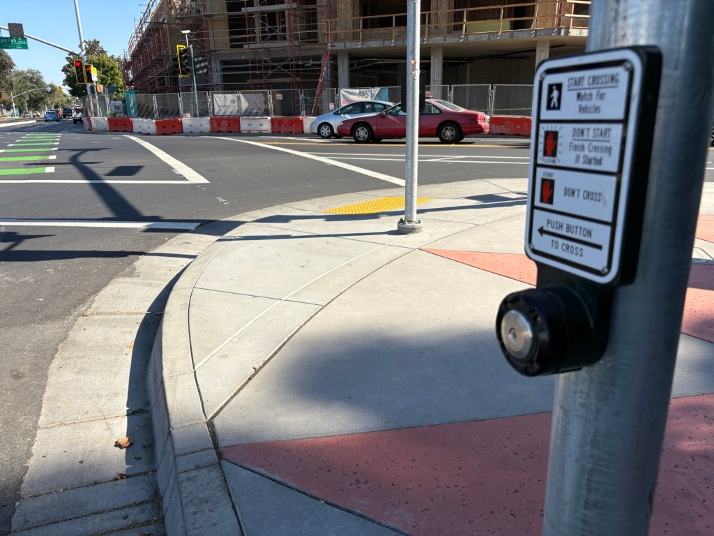
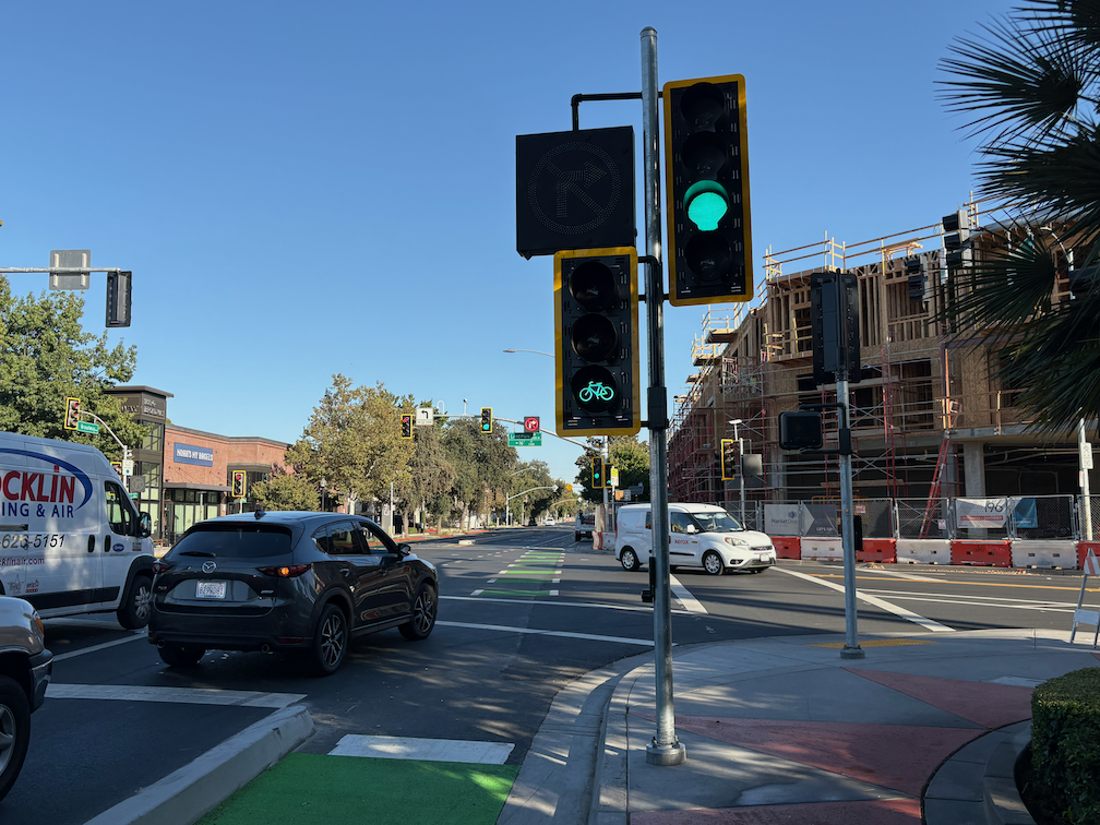
The last post I had noted that there was a required beg button for bicyclists to trigger the bike signal, but had failed to look up and notice that there was a complete set of regular signal, bike signal, and blank-out no-right-turn sign on the same post. It looks like:

For those unfamiliar with the blank-out signs, which are relatively uncommon in the city, it illuminates when turns are prohibited, and is blank when not prohibited. See photo below for the blank-out phase.
This signal array is definitely mis-communicating to drivers. When the bicycle signal is on, the no-right-turn sign should be on, and the regular signal red. This is mounted close to the right hand turn lane, and drivers see it as applying to that lane.
Most of the time, it is necessary to press the pedestrian beg button to trigger the bike signal. But then sometimes it is triggered without any press, and not due to the presence of bicyclists, as there were no bicyclists. Most signal cycles the bike signal remains red.
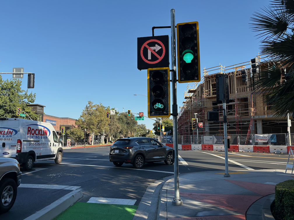
When the bike signal is on, there is a period of time when the no-right-turn sign is not on (blanked out), as below.
Do drivers follow the no-right-turn sign? In an hour of observation, I did not see one driver follow the sign. Every driver turned across the no-right-turn sign and across the green bike signal. Every. Though I did not observe it at this time, I have experienced drivers yelling at me, and other bicyclists have reported being yelled at, by drivers who think they have the right of way and wonder why bicyclists are proceeding and interfering with cars. The photo below shows just one of about 70 drivers who turned against the no-right-turn sign.
Solutions
- The regular signal should remain red while the bike signal is green. The placement of this signal is interpreted by drivers as applying to the right hand turn lane, so it must be red.
- The bike signal must have an exclusive phase where all other vehicle movements are prohibited. A properly designed intersection with a properly designed signal system probably would not need an exclusive phase, but this is NOT a properly designed intersection and NOT a properly designed signal system.
- The pedestrian beg button should be removed from the bike lane, and automatic detection of bicyclists installed. The city knows how to do this, and has done it at a few other intersections, but chose not to here.
Bicyclists will be fatally or severely injured here, and the cause of the crash will be mis-designed roadways, for which city engineers are directly responsible. Drivers are just responding to a mis-designed roadway, the guilty party is the traffic engineers.
The design document for Broadway Complete Streets, and as built, has a through lane, a dedicated left hand turn lane, and a dedicated right hand turn lane. This right hand turn lane is the source of the conflict, the source of the danger. The roadway as built prioritizes motor vehicle throughput over safety.