The Strong SacTown Street Design Standards Team has posted on Modal Filters, which are probably the most effective tool we have for calming and slowing traffic. But there are a number of others than can be used, sometimes more effective depending on the context of the street being redesigned. The traffic calming features below are listed in approximate order of effectiveness, following modal filters of course, but each street to be redesigned for traffic calming is unique, so the best solutions will vary.
The city has a parallel project, the Streets for People Active Transportation Plan. The Neighborhood Connections storymap Traffic Calming tab (scroll the menu bar right if you don’t see this tab) has great examples of many of the traffic calming features. I am using some of those in the recommendations below.
Note: A recently release study of traffic speed reductions engendered by complete streets elements in Minnesota identified roundabouts as the most effective as slowing drivers. Crossroads: Measuring the Effects of Road Features on Driving Speeds, 2024-09-11.
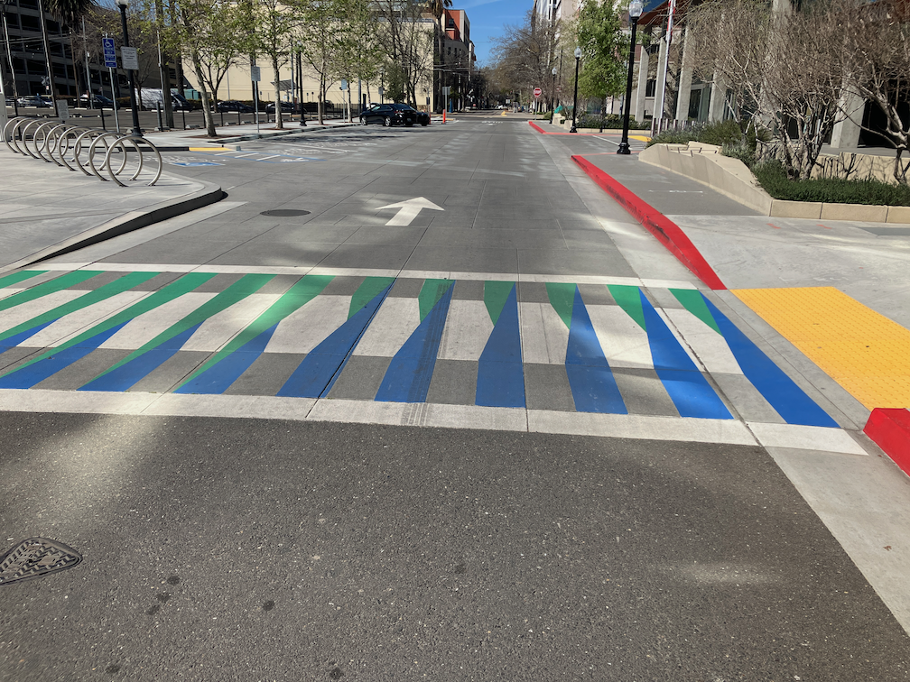
Marked Crosswalks
Though state law recognizes that there is a legal crosswalk on every side of every intersection, unless signed against, many drivers do not understand that they must yield to walkers crossing, whether the crosswalk is marked (painted) or not. The crosswalk at every side of every intersection should be painted, though low volume low speed streets may not require marked crosswalks. Decorative designs within the crosswalk further increase visibility.
decorative crosswalk, O Street in SacramentoRead More »
Several transportation advocates attended the SacATC meeting in person, several people made eComments online, and hopefully others watched via Zoom.
3. Two Rivers Trail Phase III
This project is in the selection of alternatives and preliminary design phase. It will connect the existing trail segments of the Two Rivers Trail (the one on the south side of the American River, matching the American River Parkway Trail on the north side), except for crossings of the two UPRR (Union Pacific Railroad) tracks across the river, which are under discussion but without resolution. An additional crossing is Hwy 160, with uncertainty due to there being no active project design to replace one or both sides of the bridge, which are substandard, and will need to be replaced. Commission members asked a number of questions about the alternative alignments, particularly around the old city landfill. The project will report back when alternatives are selected.
4. Street Design Standards Amendment
This was just an update on the project, which is in early stage with some meetings held but several others yet to go (stakeholders, technical advisory, and public). Actual designs were not discussed, though public comment requested that the designs be innovative and cutting edge, and that outmoded or unsafe designs in the 2009 version be eliminated completely from the amendment.
5. Active Transportation Commission 2024 Annual Report
The presentation was on the 2023 report, with some questions about formatting, but the major questions having to do with whether to carry the 2023 recommendations, which sadly have not been acted on by city council or staff, into the 2024 report, or to modify them. The consensus seems to be there there should be a list of recommendations focused on safety issues, with safety for walkers and bicyclists being a higher priority than promotion of walking and bicycling (or course, they can’t really be separated). Recommendations that do not end up on the safety list might be on a separate list, not as prominent, but not lost. There was also discussion about organizing things by short-term and longer-term, but no consensus.
Recommendation 1: Increase Funding for Active Transportation Infrastructure Projects was agreed as the top priority on any list. Recommendation 6: Create a Sacramento Quick-Build Bikeways Program, also received a lot of support, however, not universal agreement.
Discussions will continue at the September and October, and perhaps November, SacATC meetings. A number of members of the SacATC were absent, quorum just barely made, but there seemed to be agreement that the conversation would continue from this point and not go back to the beginning, and the returning members would catch up on their own.
Of course the elephant in the room is that the city council accepted the report and recommendations, but has made no policy or funding decisions to implement the recommendations. The request to add funding to the 2024-2025 city budget for any of the recommendations was rejected by the city manager. Staff has moved forward in minor ways on some of the recommendations, using existing funding and staffing.
My favorite, Recommendation 9: Finalize the Construction Detour Policy, is stalled out in Public Works, and it is not clear when or if it will ever see the light of day. Adherence to best practices for ADA accommodation and meeting PROWAG guidelines is not popular in the regressive Public Works Department.
The Sacramento Active Transportation Commission (SacATC) meets today, August 15, 2024 at 5:30 PM. in city council chambers, 915 I St. It can be viewed online by going to the city meetings page, selecting SacATC livestream. Comments are only available in-person, via the meetings page eComment, or ahead of time to the city clerk, if eComment is not working. In-person comments are the most effective.
I encourage everyone to attend in person, or watch online, and to submit comments. Recently, public participation has increased, but far too few citizens are engaged. Though the commission is not powerful, it is one of the few ways the public has of engaging the city on the public health crisis that is the epidemic of traffic violence in the city.
At the June 11 city council meeting at which the 2024-2025 budget was adopted, seven of the council members spoke strongly about the need to address safety on the city’s streets, acknowledging that the city leads California as the most deadly for roadway users. But no modification was made to the budget to reflect that priority, and the city manager refused to make any changes to the budget to fund street safety.
In the two months since that council meeting, nothing has shown up on the council agenda to move forward on street safety, nothing has shown up to allocate funds, except some minor grant applications.
The city has long had a policy that it does not fund street safety projects, except for the required grant matches. Other than grant matches, no city general funds are expended to make our streets safer. The city certainly has been successful in getting some grants, but also has not been competitive on many others.
The Sacramento Active Transportation Commission (SacATC) made a recommendation in their annual report to allocate $10M to safety projects. Council members spoke in support of the idea, but no action was taken to fund those ideas.
We have an epidemic of traffic violence in the city. Yet the city is doing almost nothing to address that. Walkers, bicyclists, drivers and passengers are all dying in horrible numbers. What is the city doing in response? Submitting grant applications and hoping for the best. This is unacceptable.
The council must take this public health crisis seriously, and allocate funds to start solving it. It must also stand up to the city manager, who does not believe in spending money on street safety. The city manager runs the city according to his own whims, and rarely follows the direction of council on anything. The council must either stand up to, or fire, the city manager. So long as he is in the position, the city will not move forward on saving the lives of vulnerable roadway users.
I’ve written before that streets should be planned from the outside in. Nearly every street I travel and nearly every plan I see for changing street width allocation clearly shows that the reverse is what was built, and what is planned.
There are a number of streets where center turn lanes are provided in blocks where there are few to no driveways. S Street near where I live is just one example. Many blocks have few to no driveways, yet the center turn lane exists all the way from 3rd Street to Alhambra Blvd. Could the street width be better used? You bet.
The most egregious example, however, is the Broadway Complete Streets project. I’ve written quite a number of posts, about the ways in which the project is successful, and the ways in which is it not. The project is such a disappointment to all the transportation advocates I talk to. Why?
Broadway was planned from the inside out. A center turn lane, all the way, whether needed or not. I’ll point out the expression, “A foolish consistency is the hobgoblin of little minds”, Ralph Waldo Emerson, from the essay Self-Reliance“. Next, two motor vehicle lanes, one each way (which is an improvement over two each way before the project). The lanes are overly wide, 11 feet when they could have been 10 feet (not less than 10, because it is a bus route). Next, traditional bike lanes, mostly five feet wide but sometimes six, sometimes with a painted buffer (no vertical delineators), sometimes without. The bike lanes could have been parking protected, but they were not. They could have been wider, so that two bicyclists could safely pass each other, and accommodate cargo bikes and three-wheeled bikes. They were not. There is a short one block section between 15th Street and 16th Street where these a curb-protected bikeway. But nowhere else.
Then comes the sidewalks. The city apparently had a design policy to not touch the sidewalks, which then engenders ADA requirements, which are somewhat expensive to meet (though a small fraction of the entire project). But they did touch the sidewalks in places, and in each of these places, the sidewalks are narrower than they were before the project. In several locations, the sidewalks do not even meet ADA or PROWAG guidelines. The city has claimed that since PROWAG has not been adopted by FHWA, the requirements don’t apply to the city. In other words, go ahead and sue us, but we aren’t going to do the right thing. That is what city staff said when challenged about this.
Has the city learned its lesson? No. The two additional segments of Broadway to the east have exactly the same design.
The city’s stated objective for this project was to slow and reduce motor vehicle traffic so that people would stop for businesses along the street, increasing economic vitality. Broadway has real problems currently, as you can see by traveling along the corridor. A lot of empty buildings, a lot of parking lots, a lot of low value fast food joints. But is also has a number of great locally owned businesses, many of which were beginning to fail due to the street design and the pandemic. I admire the city’s intent, but mourn their failure to create a street than will accomplish that.
Street design and land use are intimately connected. Street design should support surrounding land use (not land use somewhere else), and land use should take advantage of the best characteristics of streets. But in most of Sacramento, street design and land use do not support each other.
At the regional level, SACOG (Sacramento Area Council of Governments) has transportation authority but does not have land use authority. They must rely on encouragement of local governments to implement better land use, and is able to use transportation investments to a small degree to support better land use. But the City of Sacramento does have both transportation and land use authority, and could and should be planning the two in unison to accomplish a more sustainable and livable built environment.
Many of our streets are designed to allow people to pass through at high speed, not to stop for living. In some cases, this is an historical artifact because some of our major streets were at one time state highways. But other streets were designed in the same way in more recent times. The city has allowed and encouraged business development along these former highways, with more driveways, more parking, more intersections, more congestion that reduces transit effectiveness, and fewer safe crossings. At the same time, the city has widened roads and widened lanes, creating or maintaining high speed limits which are completely incompatible with the function of streets as places, or as Strong Towns puts it, places for building wealth.
The roadways which try to combine the functions of high speed and throughput with local productivity are called ‘stroads’, a street/road combination. These roadways fail at both. They must be healed by conversion to either streets or roads.
Stroad to Road
In order to bring street design and land use into alignment, the city must either redesign these stroads (a street/road hybrid) toward road function by:
Greatly reduce driveways and eliminate on-roadway parking
Eliminate signals that serve shopping centers, and replace major signalized intersections with roundabouts
Provide on-demand safe crossing at moderately frequent intervals for walkers and bicyclists
Discourage homes and businesses along these roadways
Stroad to Street
Or, redesign these stroads toward street function by:
Change roadway design to enforce motor vehicle speeds of 20 mph or less
Encourage homes and small businesses along streets
Create space for living in the public right-of-way by temporary or permanent closure of some streets, and street or sidewalk dining areas (with ADA-compliant routes).
In most cases it is more cost effective to change a stroad to a street, but both transformations are possible and necessary. We need fewer roads and more streets in our transportation system.
Land Use
An effective land use pattern offers the opportunities of daily life (jobs, businesses, dining, entertainment, groceries and shopping) within walking or bicycling distance of home. In Sacramento, the midtown section of the central city already offers this type of land use, because it was developed before the primitive concept of zoning pushed all uses further away. A few other places in Sacramento offer widely scattered examples of such land use.
Relatively few trips outside the neighborhood would be necessary if we had this type of mixed use and diverse land use. Though both land use and streets in midtown could be even better, it is an example which other neighborhoods could emulate. Of course streets must support this land use, with slow speeds which do not endanger people walking and bicycling, and where parking is sufficient but not in excess.
The city should support small businesses in every reasonable way. It need not prohibit larger businesses, but let them succeed or not on their own, without promotion or subsidy from the city.
Small parcels, often called fine-grained development, best support a diversity of housing types and businesses. The city should preserve small parcels, prohibiting consolidation except under compelling public interest, and where large parcels exist, consider purchase, division into small parcels, and sale to small scale infill developers.
Street and Land Use Supporting Each Other
Below is a photo of K Street in midtown Sacramento. The street design, one lane each way, low volume and low speed, temporary curb extensions to calm traffic, painted crosswalks, some on-street parking but reduced to increase walker safety. Of course it could be even better. The land use, a mix of storefront retail and housing, in turn supports good road design. This is a street. This is a place where people want to spend time, and spend money, and feel welcome.
street design and land use that support each other, K St, midtown Sacramento
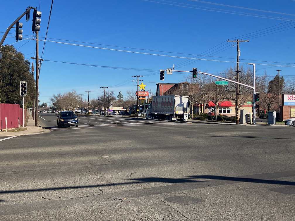
Street and Land Use Working Against Each Other
Below is a photo of Freeport Blvd at the intersection with Fruitridge Rd in south Sacramento. The street is designed for high speed travel, accommodating high volumes of motor vehicles. Bike lanes are present in some places, but dropped when necessary to promote motor vehicle flow. Dual left turn lanes endanger everyone on the road, and right turn lanes present a hazard to bicyclists. The crosswalk has faded to near invisibility. And the land use reflects those problems. Fast food businesses oriented to drivers and excluding walkers and bicyclists. A blank fence to try to isolate residences from the roadway, but of course it does not reduce exposure to noise and air pollution. Parking lots facing the street rather than storefronts. This is not a place where people feel welcome.
Freeport is NOT the worst stroad in town, by any means, but it is typical. Does the roadway encourage poor land use? Yes. Does the land use encourage the poorly designed roadway? Yes.
Additional posts on Streets for People Active Transportation Plan are at category: Active Transportation Plan.
The interactive map developed for the Streets for People Active Transportation Plan is available for public input through August 11. The ‘add a route’ and ‘add a point’ options have a free-form entry box, so you can enter anything you would like, but using terms that the city uses, in the visual glossaries (below) or the traffic calming features (below) are more likely to be understood and accepted.
You can comment on the city’s recommendations: “Clicking on a draft network recommendation will launch a pop-up that will provide more information about the recommendation. You can leave a comment, like, or dislike on any recommendation.”
Or you can add your own: “Are there roads or intersections that don’t have a recommendation, but you think should? Use the “Add a route” and “Add a point” buttons below to mark these locations on the map.”
The interactive map offers visual glossaries for pedestrian infrastructure and classes of bikeways. Since you can’t have these glossaries open at the same time as the map, they are offered as blog posts and pdf documents by Getting Around Sacramento.
The crowd-sourced entries on the map are concentrated in the central city and north Land Park. We hope that people who walk and bicycle in other parts of the city, particularly the disinvested areas of South Sacramento and North Sacramento, will make suggestions on the map.
Neither the glossaries nor traffic calming features offer fully signalized intersections as a recommendation. Traffic signals regulate motor vehicle flow to some degree, but do not significantly slow traffic nor make streets safer for walkers and bicyclists. Safety is best achieved by slowing the motor vehicles through street redesign.
The ‘bicycle routes’ / sharrows option in the Visual Glossary of Classes of Bikeways has been misused by Sacramento and many other cities/counties/Caltrans by placing them on high volume and high speed roadways, in lieu of creating safer bicycle facilities. Their use should be strictly limited, and most existing locations should be converted to higher quality bicycle facilities.
I noticed over a week ago that all striping has been removed from 5th Street, including crosswalks, so had presumed that the conversion from one-way to two-way was immanent. Nope. Nothing has happened since then. I guess the city thinks it is OK to remove striping from a street and then do nothing. In a sense, it might be OK, because drivers, without striping to guide them, will be uncertain, and slow down. Maybe.
I mistakenly included an item on 5th Street in this post, but I’ve now removed it to a separate post.
Note: Dan Allison, the primary author of this blog, spends most of July and August, and some of September, backpacking in the mountains, in the wilderness, and away from Internet access. So posts will be very intermitent, though some will show up when I’m in town, as I am for a few days.
Additional posts on Broadway Complete Streets are available at category ‘Broadway Complete Streets‘.
Green Paint
Green paint seems to be complete along the corridor, except of course for 19th Street to 22nd Street where no changes to the roadway have occurred.
18th Street Bus Stop
The project proposed to move the bus stop for Route 51 from the far side of 18th Street to the near side, in front of New Helvetia Brewing, even though far-side bus stops are preferred and safer. But the design of the sidewalk and sidewalk buffer makes it a poor bus stop, with access to the front (and handicapped ramp) and rear doors difficult. A green striped area, meaning a shared bus stop and bike lane, has been installed, but is being used as a parking area by drivers. The area is not signed for no parking, nor is the curb painted red. The bus stop has not been moved. I don’t know if it will be moved.
bus stop Broadway eastbound at 18th St, with parked cars
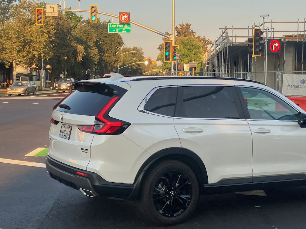
Bicycle Signal at 16th Street
The non-functional bicycle signal on Broadway eastbound at Land Park Drive now works (and has for over a week, but I didn’t get to posting until today). It took the involvement of city planning staff to get it fixed, as the traffic signal people did not care that it didn’t work, and did not fix it after multiple 311 requests.
However, it is not safe. There are large and prominent no turn blank-out signs for motor vehicle drivers turning south onto Land Park Drive, illuminated when the green bicycle light is on, and blank when it is not. The signs are hard to miss. It isn’t working.
I observed 54 drivers turning right at this intersection, not during a busy time of day. 52 of them violated the law and turned right against the no turn signs. Two did not. Both of those drivers noticed that I was taking photos, and did not turn, while looking at me to see if I was going to capture their license plate on a photo. I’m pretty sure those two would have turned if I’d not been there.
This would be a great location for a red light camera. Oh, but wait, the city has decided it is not interested in red light cameras. Drivers are free to run red lights at will, since there is no automated enforcement, and there is no direct enforcement.
The city’s design objective for streets should be that they are self-enforcing, physically making sure that drivers behave safely for all road users. This is an example where the city decided to rely on drivers following the law. Clearly a failure, on the part of the city, and the part of the drivers.
just one of many drivers violating the law by turning against the no turn signs
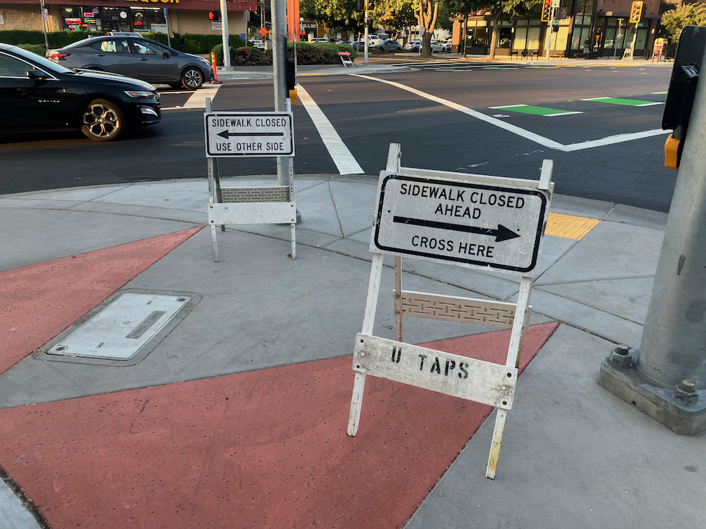
Construction Signs
At the southwest corner of Broadway and Land Park Drive, there are two sidewalk closed signs. I am not sure whether these are related to the construction on the southeast corner, or are leftover remnants of the Broadway project. In the photo below, the sign on the left is oriented to walkers heading north on Land Park Drive, but it should be oriented to walkers heading east on Broadway. The sign on the right doesn’t make any sense at all for this location, no matter how it might be oriented. Whether this is a mistake by city contractors, or the construction company, makes no difference. It is the city’s responsibility to make sure that signing is appropriate and correct. It has failed miserably at that responsibility.
incorrect construction signs southwest corner of Broadway and Land Park Dr
Photos on Flickr. An album of photos of the Broadway Complete Streets project, during and after construction. No promise is made that the album will be kept up to date.
Local Street Typology is the sixth post by Strong SacTown to improve and promote the City of Sacramento update to its Street Design Standards. Other posts at tag: street design standards.
“Local Streets are an extension of the adjacent land uses and provide space for people to socialize, play, and even loiter, and will be designed and managed as places primarily for people. People are likely to spend most of their time in or near Local Streets, since these are where to find most destinations. As such, it should feel natural and comfortable to dwell in or stroll through a Local Street. Parents should feel comfortable letting their kids play unsupervised, and noise levels are low enough to hold a conversation.”