The City of Sacramento 2024 General Plan, to be adopted February 27, includes in the Mobility element a user prioritization text and diagram, below.
This graphic and text should be added to every city document that has policy or design for roadways in the city, including Street Design Standards (2009-07, being updated), Complete Streets Policy (2019-12), Pedestrian Crossing Guidelines (2021-04), Traffic Calming Guidelines (updated), Vision Zero Action Plan (2018-08, being updated) and related VZ documents, Transportation Priorities Plan (2022-11) and related TPP documents, Creative Crosswalks (2021-05), and any other city document related to transportation.
Thanks, as always, to Matt for pointing this reference out to me, which I had somehow missed in my reading of the draft 2040 General Plan.
M-1.2: User Prioritization. The City shall prioritize mobility, comfort, health, safety, and convenience for those walking, followed by those bicycling and riding transit, ahead of design and operations for those driving.
Adoption of the 2040 General Plan will likely be on the Sacramento Council on Tuesday, February 27, one month from now. Though the plan could be even better, and its success will depend on a number of documents to be finished after adoption, this is an innovative and forward-looking document, much better than the last one. I hope that you will speak in favor of adoption at this meeting. The Climate Action and Adaptation Plan, developed separately but supposed consistent with the general plan, will be adopted at the same time. The concepts of the Missing Middle Housing Project are also largely contained in the general plan. The documents that will be developed later include Streets for People Active Transportation Plan, Parking Management Plan, and Street Design Standards, and many others.
My previous posts on the 2040 General Plan are available in category ‘General Plan 2040‘.
Save the date – put it on your calendar now! It will likely be a 5:00PM meeting, though when the General Plan comes up for comment depends on what else is on the agenda.
I am expecting widespread support for the plan, from the public and council members, but nothing is guaranteed, and there are certainly forces for the status quo.
See you then! I will post more details when they become available. Many advocacy organizations will also be supporting the plan, so look to your own organizations for additional information.
The Sacramento City Council will hear tonight (Tuesday, November 28, 2023, 5:00PM) on a recommendation to increase the floor area ratio (FAR) from 1 to 2 in areas within a half mile of frequent transit, and other improvements. The Missing Middle Housing program is part of the 2040 General Plan update. In October, staff brought missing middle housing to the council. Housing advocates led by House Sacramento suggested several improvements, and several council members spoke strongly in favor of improvements. See Sac missing middle housing project for background. So at the council meeting tonight, staff will be back with some of the recommended improvements. The documents are here: body of the staff report; table of public comments (the comments account for most of the size of the document, so the body will download much faster).
Public support for improved missing middle housing program policies and areas is critical to ensure that it will end up strong in the general plan. Though people opposed to better housing availability (NIMBYs) have so far not shown up to speak against it, they have been using their political power behind the scenes to ensure that housing remains scarce (which increases their own property values) and that their neighborhood does not change nor include people who have been excluded from housing and opportunity. Of course these Missing Middle Housing program elements will only take effect if they are not weakened when the 2040 General Plan is adopted, perhaps late next year. So housing advocates will need to remain vigilant.
Please see the House Sacramento Take Action page for information about providing public comment on the issue, and suggestions for your comments.
I believe that the public should support these changes. The general plan could be even better, by removing zoning completely, but this represents a huge improvement over both existing conditions and the earlier proposal.
Floor area ratio (FAR) changed from 1 to 2 for all areas within a half mile of frequent transit service (which means if and when areas get better transit service, they can be similarly be allows greater housing density and variety). See map below (pdf). While the area changed is not huge, it represents a huge opportunity for more housing along light rail and SacRT bus route 1 along Stockton.
The cap on dwelling per parcel are removed. Use of FAR will provide the appropriate level of control without reference to number of units. The cap on dwelling is a continuation of the exclusionary housing policies of the past.
Creation of a sliding FAR scale. To be honest, I don’t quite understand this policy, but I trust to House Sacramento that it is useful.
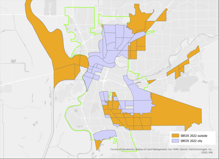
The City of Sacramento General Plan 2040 update draft offers a map of the SB 535 disadvantaged communities (DAC), on page 7-6, reproduced below. The areas are census tracts, and their number is labeled. Census tracts do not necessarily follow city boundaries, some overlap with county areas.
The general plan text states “Under SB 535, a DAC is defined as an area scoring in the top 25 percent (75th – 100th percentile) of all California census tracts for pollution burden and socioeconomic factors as measured in CalEnviroScreen.” You can read more detail about how DACs are determined, and the relationship to CalEnviroScreen, on page 7-3.
It is good that the area of ‘the finger’ (also known as the Fruitridge/Florin study area), disadvantaged communities in south Sacramento, are included, but it also makes the map hard to read. What areas are actually within the city, where the city might invest to overcome the past disinvestment that created these disadvantaged communities? To look at this question, I created the map below, which distinguishes city from county, blue being city and orange being county. It is clear that ignoring that significant areas of south Sacramento are in the county would be a mistake, but it is important to note where the city disadvantaged areas are, because that is where the city could spend money.
But these type of maps, where an area is mapped without reference to other characteristics, can be misleading. For example, the large area on the southeast side is indeed disadvantaged, but it is also mostly low density and even agricultural. The Census Bureau indicates that census tracts range between 1200 and 8000 people, with an average of 4000. Sacramento does not have such a wide range, but nevertheless, there are significant differences in the number of people residing in each census tract. The table ‘Table EJ-1: CalEnviroScreen Scores of DACs in the Planning Area’ (pages 7-4 & 7-5) lists the population density of all the tracts in the city, but unfortunately this data is not mapped. Of the disadvantaged census tracts, the population density (residents per acre) in the table range from 3.71 (6067006900, north area) to 20.71 (6067000700, northwest downtown)
So I developed a map that shows the range of densities (this is calculated for my map from area of census tract and population in 2022, not from the city’s table; the city does not indicate the date of the table data). A higher intensity of blue indicates more dense census tracts in the city, and for the county, a higher intensity of orange. As you can see, some of the city census tracts that are indicated as disadvantaged are very low density.
Why is density important? The city will never have enough money, from its own budget or other sources, to overcome past disinvestment. So investments must be prioritized. I believe the most important criteria is population density. A dollar of investment in a higher density area reaches more people. Conversely, investment in a low density area reaches fewer people. This fact is glossed over in the general plan.
There are additional maps of the disadvantaged census tracts in the general plan, focused on particular areas of the city, and addressing such issues as healthy food resources, environmental justice issues, parks, and light rail transit. It should be noted that SB 535 disadvantaged communities are only one criteria for looking at an area. The state offers Low Income High Minority (LIHM), and SACOG uses that criteria among others. All of these criteria are important, but I believe density to be one of the most important.
You may comment on the General Plan under the ‘Self-Guided Workshop‘. For a good explanation of how to use this resource, see my previous post relaying the House Sacramento guide. For my earlier posts on the General Plan, see category: General Plan 2040.
House Sacramento (SacYIMBY) has provided a simple guide to commenting on the City of Sacramento General Plan 2040 Update. I hope you will take a look and consider their priorities and comments when making your own comments to the city. The update is weak, full of glorious language, but not much in the way of commitments or actions that will really make a difference. We can greatly improve it by making comments, so please do!
I have four prior posts on the General Plan, at category General Plan 2040. Groups actively working on identifying improvements and concerns include: House Sacramento, Strong SacTown, ECOS Climate Committee, Civic Thread, 350Sacramento, and Sacramento Climate Coalition.
City of Sacramento Public Works staff has told the Active Transportation Commission that an update to the Street Design Standards will start soon. But the General Plan says otherwise. From the plan, Implementation Actions, pages 8-28 to 8-29:
M-A.10: Street Design Standards Update. The City shall review and update City Street Design Standards as needed to ensure they adequately support objectives for prioritizing people throughput, safety, and efficient transportation management. Responsible Entity: Department of Public Works Timeframe: Mid-term (2030-2035)
This timeframe indicates that the update will not even start until 2030, six years after the adoption of the plan in 2024. Six years of Public Works enforcing outmoded and dangerous street designs on the public and on developers. Hopefully the plan is out of date, and staff is correct that it will start soon.
Yes, I had promised quite some while ago a summary of my many blog posts on the Street Design Standards update. Coming soon to a blog near you.
At the meeting of the ECOS Climate Committee on Tuesday, June 27, there was a presentation on the City of Sacramento General Plan 2040 Update by city staff Remi Mendoza. The presentation gave an overview of the plan, which is pretty much available on the city website, but the questions and comments were interesting.
Heather Fargo raised issue of language to address disability transportation concerns; does plan address sidewalk maintenance? Staff did not really answer about disabled mobility, rather, the answer was about walking and bicycling for other people. Heather said she is dissatisfied with bicyclist improvements which make things harder for disability. I will ask Heather for clarification on her concerns. Heather also expressed a number of concerns about the lack of a commitment to protecting agricultural and wildlife lands in the Natomas Basin and Natomas area, both in the main general plan and in the specific North Natomas Community Plan.
I asked two questions:
Why is the council commitment to removing parking mandates now a weak ‘could include’? Staff answered that a consultant is working on this, and if council wants stronger language, it can reinstitute it. This is a very dissatisfying answer. If the council wanted weaker language, they could asked for it, but they have not. I suspect that some politically powerful people (more powerful than you or I) asked for the language to be weakened, and staff complied. Was this City Manager Howard Chan, or was it one of the powerful who is not on the council?
Map M-3 emphasizes light rail and arterials for transit oriented development. These are both NOT the best locations due to surrounding land use (often industrial and toxic), poor accessibility to transit (long distances to safe crosswalks over high speed, high volume, very wide arterials), lack of existing neighborhoods to build on in several cases, and the pollution created along these freight routes and motor vehicle traffic sewers. This question was brushed off.
A number of others asked questions about the plan, which were only partially answered. It appears that the transportation and climate community are very concerned about the general plan. And they should be.
The members of city Community Development Department, which initially seemed to be on board with very innovative and future-looking goals and policies, seems to have backed way off, and are now proposing something not remarkable different from the current 2035 plan, which was outdated before it was even adopted.
I appreciate ECOS (Environmental Council of Sacramento) for their willingness to stand up to the powers that be. I’m a member of a number of other groups that are not willing to stand up. The city and the county, and the other cities in the county, get away with the status quo and gaslighting because no one is calling them out on their poor decisions and lack of attention to the needs of the people who live here.
As mentioned earlier, the draft City of Sacramento 2040 General Plan has been released. For transportation advocates, the two most important chapters are Chapter 3: Land Use and Placemaking and Chapter 8: Mobility. Land use and transportation are so closely tied that I’m a little confused at to why the city separated them into separate chapters. Though the text which introduces each chapter (element), and each Goal and Policy section within the chapter, often refers to other parts of the plan, it seems to me that they were written independently and linked after the fact.
Element 3, Land Use and Placemaking, has the following sections:
Land Use Framework
Integrating Infill Development
Thriving Commercial Mixed-Use Centers
Complete and Inclusive Neighborhoods
Industrial Areas
Placemaking, Green Building, and the Arts
Element 8, Mobility, has the following sections:
A Multimodal System
Reduced Reliance on Single-Occupant Vehicles
Safety
Regional Connectivity
Supporting Goals through Data, Technology, and Innovation
There are a number of organizations taking deeper dives into the General Plan draft, and I encourage you to join one of them:
there are not doubt others; ask your organization what it is doing
Or, if you have the time, do your own deep dive. Of maybe transportation and land use are not your focus, there are seven other areas that may interested you.
Though the General Plan is not really a legally binding document, it is a tool that advocates can use when asking the city ‘why aren’t you doing this?’ or ‘why are you doing this?’. So it is important that the final plan reflect the desires of the citizens, and the reality of climate change and lack of equity.
You can expect more posts on the General Plan, as I have time to look into the details.
There are a number of things the City of Sacramento could be doing to better manage parking: Parking reform for Sacramento. But perhaps the most important is removing parking mandates, those city regulations that require developers to put in parking whether it is needed or will be used, or not.
The city council in January 2021 adopted the Proposed Roadway Changes document that had been recommended by staff working on the 2040 General Plan update. This is a very large document, so the relevant section on parking is excerpted. It states, in unequivocal terms:
10. Eliminate City-mandated parking minimums citywide and introduce parking maximums.
City of Sacramento, Council Report 15, 2021-01-19, 2040 General Plan Update – Draft Land Use Map, Proposed Roadway Changes, and other Key Strategies
Here we are, about two years later, and the staff is recommending considerably less in the draft plan, that action ‘could include’. Not will include, not studied on a timeline, not implemented, but maybe we will think about it, if we get around to that. Could that city have come up with any more vague and unserious language?
M-2.17 Parking Management Strategy. The City shall continue to deploy a parking management strategy that optimizes the use of existing supply, minimizes the need for the construction of new parking facilities, and promotes the use of active modes of transportation, public transit, and highoccupancy vehicles. Program components could include the following:
Adjusting parking management strategies based on goals and needs;
Adjusting parking meter hours and pricing for effective management;
Eliminating City-mandated parking minimums;
Implementing parking maximums along established transit corridors;
Allowing unbundled parking in conjunction with strategies to reduce the need for private automobiles;
Incorporating or facilitating technology such as smart-phone apps and wayfinding signage that direct drivers to open parking spaces in real-time, automated and/ or stacked parking systems, or parking technologies that improve parking efficiency in mixed-use centers and corridors;
Supporting the use of alternative modes by providing alternative programs in lieu of monthly parking passes and discounts; and
Improving branding, communications, and wayfinding signage.
City of Sacramento, draft 2040 General Plan
It should be noted that the General Plan language implies that the city has a parking management strategy, or a parking management plan. So far as the public knows, it does not. So the city is referencing something that either does not exist or has never been shared with the public. The first thing that the General Plan must include is a commitment to developing a parking management plan, with public engagement, and then sharing the plan with the public. The plan does not even mention this.
Three orientation webinars (scroll down the page above to the webinar signups)
The plan itself, available as a pdf on the General Plan page. The Climate Action and Adaptation Plan is also available there.
A number of organizations. and individuals, will be reviewing the plan, and providing information to their members. Dive in if you have the time, or wait for some guidance from others.
The General Plan is probably the most important document that the city will put out, since it will address zoning changes to allow more housing, and more affordable housing, which helps every other aspect of livability in the city.