missing alternatives for Yolo 80 Managed Lanes Project

Note: This post was rushed out and not well written, so I’ve revised it.

The Caltrans-led Yolo 80 Managed Lanes Project suggests adding roadway capacity to the Yolo Causeway in a number of different configurations. The project alternatives listed are:

  • No build: Alternative 1: This alternative does not address the purpose and need of the project by not making corridor improvements and relieving traffic congestion.
  • Build Alternative 2: Add a High Occupancy Vehicle (HOV) lane in each direction for use by vehicles with two or more riders (HOV 2+).
  • Build Alternative 3: Add a High Occupancy Toll (HOT) in each direction for use by vehicles with two or more riders (HOT 2+).
  • Build Alternative 4: Add a HOT lane in each direction for use by vehicles with three or more riders (HOT 3+) Lane in Each Direction.
  • Build Alternative 5: Add an Express Lane in each direction (everyone using the lane pays to use the lane, regardless of number of riders.).
  • Build Alternative 6: Add a Transit-only lane in each direction.
  • Build Alternative 7: Repurpose the current #1 general purpose lane to HOV 2+. No new lanes would be constructed.
  • Build Alternative 8: Add a HOV 2+ lane in each direction with I-80 connector ramp.

Of these alternatives, the only one which would not increase VMT (vehicle miles traveled) is #7, converting an existing general purpose lane to HOV 2+. Caltrans has on many projects claimed that state law does not allow this, but Yolo County forced Caltrans into including this option. All the other alternatives (except no build) would increase VMT ranging from a little to a lot.

It is true that the bulk of the motor vehicle traffic between Sacramento and Davis is not commuting traffic, but it is also true that the addition of commuter traffic to the background bay area to Sacramento and beyond is what causes the worst congestion episodes. Actually, the worst episodes are caused by traffic crashes, which none of these alternative would address. Caltrans sees traffic crashes as just part of the cost of doing business, and does not see reducing these as their responsibility.

The alternatives identified are missing two important ideas.

One alternative not mentioned is to increase service on Capitol Corridor between Sacramento and Davis to hourly or better, all day, over a longer range of hours. The trip on the Capitol Corridor takes only 15-minutes, about the same as the freeway when it is free-flowing, and far better than the one hour bus trip.

Many people have said that increasing passenger service on Union Pacific-owned tracks is impossible, because UP won’t allow more passenger trains without substantial taxpayer subsidies for track improvements. The Sacramento-Roseville third track project is basically a bribe to UP to allow some more passenger service. I don’t see this as a valid argument. Though freight railroads are regulated by the federal government, not the state, there are dozens of ways in which the state can put pressure on UP by withdrawing support and permission unless there is cooperation. UP net worth is $139B, large for a transportation company but very small in the world of corporations, while California is the fifth largest economy in the world. Are you saying that California has no leverage over UP? California could even buy out all UP tracks in the state, thereby solving the passenger vs. freight issue.

The second missed alternative is to subsidize high frequency bus service, 15-minute or 30-minute, on all weekdays, with a long range of hours, at least 5:00AM to 11:00PM. Service on weekends might be only hourly, but it would be a 30 minute trip without stops, rather than the hour-long Yolobus service. If Yolobus could afford to offer high frequency service between Sacramento, West Sacramento, and Davis, they would already be doing so. High frequency service could be offered for years on the same amount of money that will be wasted on capacity expansion for motor vehicles. The project alternatives do offer some support for buses, as buses can use HOV (high occupancy vehicle) and HOT (high occupancy toll) lanes, and alternative 7 even has dedicated bus lanes. But there is no mention of how this would be taken advantage of. If funding for buses is not increased, buses will not be a significant solution for the corridor.

Caltrans of course has no desire to fund non-motor vehicle transportation, despite slapping the ‘multi-modal’ label on everything they propose. As always in Caltrans District 3, walking, bicycling and transit are an afterthought, crumbs added if it doesn’t seem to interfere with private vehicles and commercial freight, not part of the project design criteria.

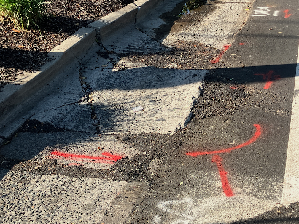
The Caltrans presentation on the project does not mention bicycles at all. There is an existing bike route all the way from Davis at Olive Drive offramp to West Sacramento at the Capitol Avenue onramp. There is a 3-mile Class 1 path from Olive Drive to county road 32A, then a shoulder on 32A, then a 4-mile Class 1 path to the edge of West Sacramento. There portion of the path on the elevated causeway bridge is in decent shape, but the asphalt part is seriously deteriorated. Whether the project means to improve the path or not is unanswered. To Caltrans, ‘multi-modal’ is just a catch phrase, not meant to be taken seriously. Even if this path is improved, the ride alongside the freeway will still be very unpleasant. The ultimate solution is to move the path north of the railroad, far away from the freeway.

Check the City of Davis, City of West Sacramento, and Yolo County pages on the project. Note that the alternatives listed, project description, and maps are somewhat different on each of these pages, because they were created at different point in time of the project planning.

It is not clear from any of the pages whether there is a still a chance for public input. Workshops were conducted in 2022. Whether or not there is still an open process, you can email Caltrans (Yolo80corridor@dot.ca.gov), City of Davis, City of West Sacramento, and Yolo County with your opinions.

9th St bikeway finally open again

The parking-protected, separated bikeway on 9th Street between K Street and L Street is finally open again, 2-1/2 years after it was closed for construction conversion of the Capitol Park Hotel by Mercy Housing. Though the area was occasionally used for active construction, mostly it was used for long-term storage of construction materials.

The sidewalk is still not open.

9th St separated bikeway K to L reopened

19th St gutter fix

This is Central City Mobility Project update #20.

Apparently it does help to complain, at least sometimes. The city is fixing the root heave and gutter on 19th Street between Matsui Alley and N Street, which I posted on recently (hazardous bikeway on 19th St). I had submitted several 311 reports on this issue, and so had other people, and it seems we got through to Public Works.

The gutter is being replaced at the root heave, and other deteriorated locations in that half block. The photo below shows a night-time view, and I’ll add a daytime view and a view when the project is complete. Note that the bikeway is being appropriately diverted into the parking lane. It is unusual for the city to provide an equivalent accommodation for bicyclists.

gutter fix work on 19th St bikeway between Matsui Alley and N St

Of course there are several more blocks on 19th Street where the gutter pan is deteriorated enough that it doesn’t provide a bikeway surface and the bikeway therefore does not meet standards. However, this was the worst and most dangerous location, so there is progress.

hazardous bikeway on 19th St

This is Central City Mobility Project update #19.

I have mentioned the problems with the gutter pan on several blocks of the new bikeway on 19th Street being so deteriorated that the effective width of the bikeway is only about two feet. It is clear that the city did not look at the existing conditions of the gutter before deciding to place the bikeway in this gutter. But, this is not an easy thing to fix. There are at least four blocks that are unacceptable, but it will probably require reconstruction of the gutter pan to fix it.

What can be fixed, but has not been, is the root heave in the 19th Street bikeway at Matsui Alley (note that Matsui is discontinuous, and is present only on the west side of 19th Street; the alley does not exist on the east side.) The photo below shows the root heave, but doesn’t really emphasize how big it is. There is a four inch displacement. This is a pavement flaw that could easily cause a bicyclist to crash. I don’t know whether the orange paint marking is from the city or bicyclists, but orange paint is not visible at night, and even in daytime it doesn’t make clear what the rider should do to avoid the hazard.

19th St bikeway at Matsui-Alley root heave
19th St bikeway at Matsui Alley root heave

I have reported this issue to the city 311 app several times. I know of at least two other bicyclists who have reported it multiple times. The city 311 incident map shows only my latest report (230805-1907594), which means that the city has closed all the other reports without any action.

Allowing this type of hazard to exist, when it is a known hazard, particularly in a location designed to attract bicyclists, is criminally negligent. Let me repeat that for the idiots in Public Works, who seem to be hard of hearing – CRIMINALLY NEGLIGENT.

If you are a bicyclist who is using 19th Street, I encourage you to NOT use the bikeway in this block between Capitol Avenue and N Street. Ride in the middle of the general purpose travel lane instead. And if you have the time, file a 311 report on the hazard. It will become increasingly difficult for the city to claim it didn’t know about this problem (by closing the reports without action), the more people report it.

Central City Mobility update K71, curbs

This is Central City Mobility Project update #18.

Flexible delineators have been installed along part of 21st Street, and are undergoing active installation this week. These K-71 posts are more substantial that the traditional vertical delineators. They can still be run over, and are run over, but since they look more substantial, drivers are less likely to run over them. They are still plastic, so provide no actual protection from errant motor vehicles; only hard curbs or true bollards (steel or concrete) can do that, but still, an improvement over earlier designs.

Central City Mobility Project, 21st St, K71 delineators

I don’t know how quickly the otherwise completed sections of the Central City Mobility Project will have these delineators installed. Apparently there is a US-wide shortage of materials for separated bikeways, and many cities are not able to complete their projects.

A second change since my last posting is that some parking spot paint is showing up. I had thought that parts of the striping that were still missing after quite some while were just missed, but in fact at least some of them were intended for parking regulation marking. The photo below shows a yellow curb and yellow stripe adjacent to the parking spots. I am glad to see that both the curb and the parking lane are being marked with paint. Otherwise, many drivers would fail to see, or pretend not to see, the curb color alone. This is hard to miss!

Central City Mobility Project, 21st St, yellow curb and parking marking

In California, painted curbs have the following meaning:

  • red – no stopping, standing, or parking
  • yellow – commercial loading and unloading (can also be used for passenger loading and unloading, unless otherwise signed)
  • white – passenger loading and unloading
  • green – limited time parking, as posted on a sign or the curb
  • blue – disabled parking (must have a license plate or temporary hanger tag)

In Sacramento, and many places in California, parking enforcement takes a laissez faire attitude towards curb colors. Except for red curbs, they are seldom enforced, and even red curb enforcement is uneven. Note that red curbs are really intended to mean what they say. If you stop there, you are in violation. A typical driver excuse for any parking violation is that they were ‘just going in for a moment’. Moments turn into minutes turn into hours, as I have observed many, many times. If you get out of your car, you are parking, no matter what the driver calls it, the law calls it parking. Parking on white and yellow curbs is a violation. Obviously commercial loading and unloading may take some time, but if there is no active loading or unloading going on, that is a violation.

I like green curbs as a solution for businesses where people pick up food and beverages. Fast food places where people order ahead. Coffee shops. My local coffee shop has a green curb right outside, and it is used for its intended purpose by some drivers. Other drivers just take it as an open free parking spot. I have reported these to city 311 as violations, but the city has not enforced so far as I am aware. More green curbs, please! (note that in the photo, the motor vehicle had just pulled into the curb, and the driver was crossing the street to pick up food at one of the businesses on the west side of 15th St; the parking meters are not functional, but the 15 minute limit is clearly posted)

green curb 15 minute parking, 15th St, Naked Lounge

Because past enforcement has been laissez faire, it will take some signing and education to make these curb colors work. Most drivers in California don’t really understand curb colors; I used to work in Nevada, and I can tell you most drivers there know exactly what they mean.

I am very pleased to see that curb colors are being more actively used in the city. Illegal parking endangers bicyclists, in particular, but also walkers and drivers. Of course something must be done to get delivery vehicles out of bike lanes and out of blocking streets and crosswalks. The city is far, far from having a plan to address that.

Other

19th St: no active work south of Q St

10th St: street being prepared for repaving and re-striping

I St: street being prepared for repaving and re-striping

5th St, 9th St: no active work

Nothing has been installed in the ‘turn wedges of death‘. I looked at the detailed design for these turn wedges (another advocate was able to obtain them), and it is still not clear what is intended for these locations. The bicycle signal at 21st and H Sts has not been installed, nor is there any sign cautioning bicyclist from using the pedestrian signal, which exposes them to high speed left turning motor vehicles.

SacCity SB 535 disadvantaged communities and density

The City of Sacramento General Plan 2040 update draft offers a map of the SB 535 disadvantaged communities (DAC), on page 7-6, reproduced below. The areas are census tracts, and their number is labeled. Census tracts do not necessarily follow city boundaries, some overlap with county areas.

The general plan text states “Under SB 535, a DAC is defined as an area scoring in the top 25 percent (75th – 100th percentile) of all California census tracts for pollution burden and socioeconomic factors as measured in CalEnviroScreen.” You can read more detail about how DACs are determined, and the relationship to CalEnviroScreen, on page 7-3.

It is good that the area of ‘the finger’ (also known as the Fruitridge/Florin study area), disadvantaged communities in south Sacramento, are included, but it also makes the map hard to read. What areas are actually within the city, where the city might invest to overcome the past disinvestment that created these disadvantaged communities? To look at this question, I created the map below, which distinguishes city from county, blue being city and orange being county. It is clear that ignoring that significant areas of south Sacramento are in the county would be a mistake, but it is important to note where the city disadvantaged areas are, because that is where the city could spend money.

But these type of maps, where an area is mapped without reference to other characteristics, can be misleading. For example, the large area on the southeast side is indeed disadvantaged, but it is also mostly low density and even agricultural. The Census Bureau indicates that census tracts range between 1200 and 8000 people, with an average of 4000. Sacramento does not have such a wide range, but nevertheless, there are significant differences in the number of people residing in each census tract. The table ‘Table EJ-1: CalEnviroScreen Scores of DACs in the Planning Area’ (pages 7-4 & 7-5) lists the population density of all the tracts in the city, but unfortunately this data is not mapped. Of the disadvantaged census tracts, the population density (residents per acre) in the table range from 3.71 (6067006900, north area) to 20.71 (6067000700, northwest downtown)

So I developed a map that shows the range of densities (this is calculated for my map from area of census tract and population in 2022, not from the city’s table; the city does not indicate the date of the table data). A higher intensity of blue indicates more dense census tracts in the city, and for the county, a higher intensity of orange. As you can see, some of the city census tracts that are indicated as disadvantaged are very low density.

Why is density important? The city will never have enough money, from its own budget or other sources, to overcome past disinvestment. So investments must be prioritized. I believe the most important criteria is population density. A dollar of investment in a higher density area reaches more people. Conversely, investment in a low density area reaches fewer people. This fact is glossed over in the general plan.

There are additional maps of the disadvantaged census tracts in the general plan, focused on particular areas of the city, and addressing such issues as healthy food resources, environmental justice issues, parks, and light rail transit. It should be noted that SB 535 disadvantaged communities are only one criteria for looking at an area. The state offers Low Income High Minority (LIHM), and SACOG uses that criteria among others. All of these criteria are important, but I believe density to be one of the most important.

You may comment on the General Plan under the ‘Self-Guided Workshop‘. For a good explanation of how to use this resource, see my previous post relaying the House Sacramento guide. For my earlier posts on the General Plan, see category: General Plan 2040.

PDF versions of the maps are available: SB 535 census tracts from General Plan; SB 535 city/county; SB 535 weighted for population density.

House Sac guide to General Plan update

House Sacramento (SacYIMBY) has provided a simple guide to commenting on the City of Sacramento General Plan 2040 Update. I hope you will take a look and consider their priorities and comments when making your own comments to the city. The update is weak, full of glorious language, but not much in the way of commitments or actions that will really make a difference. We can greatly improve it by making comments, so please do!

I have four prior posts on the General Plan, at category General Plan 2040. Groups actively working on identifying improvements and concerns include: House Sacramento, Strong SacTown, ECOS Climate Committee, Civic Thread, 350Sacramento, and Sacramento Climate Coalition.

parking and bikeways

A number of people have commented, here and other places, that my idea of converting parallel parking to diagonal parking is wrong. There should be bike lanes instead. These comments come from a misunderstanding of context. I’ve written some while ago about diagonal parking, and it is mentioned in many of my posts about parking and street design, particularly sidewalk-level bikeways and bike lane widths.

What I intend is a transportation system where:

  1. Streets designed for 20 mph and under don’t need any bike facilities, as they are naturally traffic calmed. Bike lanes would be a waste of space. Where these streets are too wide, diagonal parking is a great solution for narrowing the street.
  2. Streets from 21 to 30 mph need standard Class 2 bike lanes. Visual separation from motor vehicles is needed.
  3. Streets from 31 to 40 mp need separated bikeways. In most cases these should be at sidewalk level, not at street level, but street level bikeways can be a temporary measure until the street is redesigned. These bikeways need to be sufficiently wide to accommodate passing and all types (widths) of bicycles and mobility devices.
  4. Streets 41 mph and above are NOT streets, they are roads, and should be designed as such. No driveways, no street facing retail or commercial, few intersections. These are for getting someplace fast. These roads do not need bicycle facilities at the edge of the road. What is needed is a completely separate transportation system that keeps bicyclist safe and completely separated from motor vehicle traffic.

Is any of this real right now? No. Nothing like this exists in the Sacramento region. But I strongly believe it is the goal we should be moving towards, with haste. And diagonal parking on slow but overly wide streets provides traffic calming and more efficient use of space.

Walkable City book club: Step 5: Protect the Pedestrian

The Walkable City book club will meet again this Wednesday at Lefty’s Taproom, 5610 Elvas Ave, in east Sacramento, 6:00PM to about 7:30PM. If you can’t arrive at the beginning, or need to leave sooner, that is fine, your presence is welcome for whatever you can make. Though some of the people in the book club group are ‘walkable city’ advocates, there are also people who are simply interested in making Sacramento more walkable, and more safe. Everyone is an expert when it comes to identifying what aspects of our transportation system don’t work for them personally, and the others are happy to fill you in on what we call the problems and possible solutions to those problems. We also celebrate the walkable nature of some places in Sacramento. Though many of us live in the City of Sacramento, we also discuss areas throughout the region. So please join us!

Walkable City: How Downtown Can Save American, One Step at a Time, 10th Anniversary Edition, Jeff Speck. Sacramento County Library has one copy of the 10th edition, waitlisted, and one copy of the 2012 edition, available. It is of course also available from your local bookstore, though it may need to be ordered, and Amazon has Kindle, paper and hardback versions.

The Walkable City book club: Step 5: Protect the Pedestrian section has eight parts:

Read More »

change it before someone gets killed

This is Central City Mobility Project update #17.

I regularly ride the newly repaved streets with separated and/or parking protected bikeways, because I want to see how bicyclists and drivers are dealing with the new design. Well, the turn wedges are a complete failure. At every intersection where there is a turn wedge for left turns, drivers are cutting the corner and turning at higher speeds than they did before. The city has created a danger that was not present before, when there were regular bike lanes. The city has not completed work on the turn wedges, and for now, they are an incredible danger to bicyclists. The city has not placed construction signs at these locations, though at least according to the rough designs the city has shared with the public, construction is not complete. Nothing has been installed in the turn wedges. That means that the city has left the project in an incomplete state, but is communicating to the public that the project is complete.

The number of close calls that I have personally experienced at these turn wedges now numbers over 40. As an experienced bicyclist, I know what to watch out for and respond, but having to slam on my brakes to keep from getting run over is not something I or any other bicyclist should have to do.

The city must stop this madness before people die. The city knowingly has installed unsafe roadways, and has not fixed them despite knowing that they are hazardous. This means that the city is legally responsible for any bicyclist-driver crashes that happen at those corners. I will happily testify against the city, and hope that they have to pay our millions for their incompetence. But of course someone will be dead or severely injured, and the city won’t have to be liable for that. Traffic engineers depend on ‘approved’ designs to isolate themselves from direct legal responsibility, but these are not approved designs, they are ones that the city invented using pieces and parts of internationally recognized designs.

City, fix this now, or suffer the consequences!