Broadway diagonal ramps

Additional posts on Broadway Complete Streets are available at category ‘Broadway Complete Streets‘.

Many of the corner ADA ramps already installed and to be installed as part of the Broadway Complete Streets project are diagonal ramps. Diagonal ramps were a common solution in the past for corners because they save a little bit of money, and sometimes avoid drain inlets that perpendicular ramp would conflict with. Changing drain inlet locations can be expensive. However, diagonal ramps have never been the optimal solution for corners, and since August 2023, they are not permitted under PROWAG (Public Right of Way Accessibility Guidelines), except under rare circumstances. In those rare circumstances, the ramp must be completely contained within the two crosswalks, which often leads to awkward crosswalks.

There are very few diagonal ramps in the Sacramento central city, so it is surprising that they will be so common at the edge of the central city, Broadway, as part of a complete streets project.

Some transportation agencies have been claiming that they don’t need to follow PROWAG since it has not yet been adopted by USDOJ and USDOT, however, that just means that it is not yet legally enforceable on agencies. But the regulation has been promulgated and published and is now the law.

The project engineer for Broadway Complete Streets has claimed that the diagonal ramps are specified because of “design constraints”. I have looked at every corner where a diagonal ramp was placed, and I see nothing that constitutes a constraint. It may be that what the city means is that it didn’t fit in the budget to install perpendicular ramps, but that is not a valid exception in PROWAG. It is worth remembering that the concrete being installed under this project will be in place for at least 30 years, so that means the city is constructing corners and ramps that are already outmoded, and will be far more so in 30 years.

Of the 15 locations that will have new diagonal ramps, and the 2 that apparently will be unchanged, the northwest corner of Broadway and 18th Street will serve as an example. The other three corners here have perpendicular ramps, but for unknown reasons, the northwest has a diagonal ramp.

photo of Broadway & 18th St diagonal ramp
Broadway & 18th St diagonal ramp

The diagram below, from NACTO, shows perpendicular ramps. Note also the tight turning radius, which slows turning drivers. Of course the optimal is if these ramps are contained within a curb extension, but even without that, they are a good practice.

diagram of NACTO perpendicular ramps
NACTO perpendicular ramps

The next diagram snows perpendicular ramps in the context of curb extensions, and illustrates the huge benefit of curb extensions, which is increased visibility between walkers and roadway users. The curb extension also removes the need to paint the curb red or place a sign, one of which is required now under AB 413 (Lee, 2023). Caltrans includes curb extensions in its Pedestrian Safety Countermeasures Toolbox.

diagram of curb extension creating visibility (source unknown)
curb extension creating visibility (source unknown)

The table below shows the plan for each corner along the corridor from 3rd Street to 24th Street, with details about ramps and curb extensions. The plan I have does not include any change from the west side of 19th Street to the east side of 21st Street. This section includes the crossing between 19th and 20th by light rail and railroad tracks. It is unknown why this is.

Cross-streetNWNESWSENotes
3rd SNoneNoneDiagonal existingDiagonal newNo crosswalks
3rd NDiagonal newDiagonal existingNoneNoneNo crosswalks
5thPerpendicular newPerpendicular newPerpendicular newPerpendicular new
6thDiagonal newPerpendicular existNoneSingleW crosswalk removed
Midblock


New, single with extensions
8thDiagonal existingDiagonal newNoneNoneNo crosswalks
Muir WayNoneNoneDiagonal newDiagonal newNo E crosswalk
9thDiagonal newPerpendicular existNoneNoneNo crosswalks
10thPerpendicular newPerpendicular newSingle, extensionSingle, extension
RiversideDiagonal newDiagonal newDiagonal newDiagonal new, extension
13thPerpendicular existPerpendicular new, extensionSingleSingle
14th Perpendicular new, extensionPerpendicular new, extensionPerpendicular new, extensionPerpendicular new, extension
15thPerpendicular newDiagonal newSingleNoneNo E crosswalk
16th/Land ParkPerpendicular newPerpendicular new, extensionDiagonal newPerpendicular new, extensionW crosswalk unknown
17thPerpendicular newPerpendicular new, extensionDiagonal new, extensionPerpendicular new, extensionW crosswalk removed
18thPerpendicular new, extensionDiagonal newPerpendicular new, extensionPerpendicular new, extension
19th


Unknown
20th


Unknown
21st


Unknown
22ndPerpendicular newPerpendicular new, extensionNoneSingle, extensionW crosswalk removed
23rdPerpendicular new, extensionPerpendicular new, extensionSingle, extensionNoneW crosswalk only
24thNo changeNo changeNo changeNo change
table of Broadway Complete Streets corners and curb extensions

Communities Over Highways Campaign

America Walks has created a Communities Over Highways Campaign. The campaign asks for a moratorium on highways, and instead invest in:

  • fix-it-first
  • safety over speed
  • make transit work
  • reconnect communities

STAR and SABA have already signed on to the campaign, and individuals are encouraged to send letters to their elected representatives. For me, living in Sacramento, the letter goes to Governor Gavin Newsom, State Senator Angelique Ashby, Assemblymember Kevin McCarty, Representative Doris Matsui, Senator Alex Padilla, and Senator Laphonza Butler.

SacATC February 15, includes Truxel Bridge

The monthly meeting of the Sacramento Active Transportation Commission (SacATC) will be this Thursday, February 15, 2024, starting at 5:30 PM in the city council chambers. The agenda includes five items. You can comment on these items, or on topics not on the agenda, ahead of time via eComment, or in person at the meeting. I encourage people to attend these commission meetings. There are usually very few members of the public in attendance, which means that your voice is important. Though eComments are valuable, in-person comments carry a lot more weight. The city’s planning staff is usually progressive and innovative, but Public Works in general is not, so it is important the citizens show up to push for progressive and innovative projects and policies. With some new appointments to the commission, and support of the public, the commission itself has been much more progressive than in past years.

Agenda item 3 is a presentation on the Truxel Bridge Concept and Feasibility Study. The Truxel crossing of the American River was originally proposed and approved by SacRT and the county as a transit-walking-bicycling bridge, carrying light rail from downtown to Natomas. The city is now proposing a motor vehicle-transit-walking-bicycling bridge. They are claiming that the bridge would reduce vehicle miles traveled (VMT) through the provision of alternative modes, and a shorter trip between downtown and Natomas, but has not presented data to justify this claim. New roadway capacity induces more motor vehicle trips, a well-established fact, so to claim otherwise requires proof. Walking and bicycling would be unlikely to be the major component of bridge users. Transit availability could reduce motor vehicle trips, but the Green Line to the Airport is probably decades away, and anything short of service to North Natomas would be unlikely to replace many car trips.

The city intends to go full speed ahead (pun intended) with the bridge, based on a 2013 city council approval, seeking public input only on the southern approach to the bridge and the bridge cross-section. Since 2013, the city has declared a climate emergency, the Mayors Commission on Climate Change goal is to achieve Carbon Zero by reducing VMT, the soon-to-be-adopted General Plan 2040 and Climate Action and Adaptation Plan aim for reducing VMT rather than increasing it, and SB 745 required VMT impacts as the primary criteria for judging projects. Most importantly, public awareness of the risk of motor vehicle induced climate change has emerged and strengthened.

Read More »

Broadway too-narrow sidewalks

This is a follow-up to my serious concerns about Broadway post. There will be additional posts about the Broadway Complete Streets project. The Broadway Complete Streets project is underway, with several locations of corners, midblock crossings, curbs, and sidewalks already reconstructed.

It is clear that throughout the planning and construction of this project, sidewalks were ignored or discounted. The project is all about the roadway, reducing motor vehicle lanes to 2 plus a turn lane (from 4), and adding buffered bikeways. It is common in project planning to assume that sidewalks will not be disturbed, and therefore do not need to be brought up to current ADA/PROWAG requirements. However, sidewalks are being replaced, newly constructed, in several locations along Broadway. That means they do have to meet current requirements, and that requirement is a clear width of 48 inches.

The Broadway Complete Streets Final Recommendations (2016) document identifies ‘Sidewalk obstructions or narrow sidewalks’ as a critical issue. It also says “The proposed road diet allows for a buffered bike lane through the entire corridor, and presents opportunities for pedestrian crossing improvements, new pedestrian crossings, and sidewalk enhancements.” However, other than curb extensions at intersections and mid-block crossings, nothing in the design actually enhances sidewalks. The ‘typical cross section proposed’ is below. Though the diagram shows 8 foot sidewalks, the actual sidewalk width varies greatly along the corridor.

diagram of Broadway Complete Streets typical cross-section proposed
Broadway Complete Streets typical cross-section proposed
Read More »

Traffic Safety Forum

Slow Down Sacramento has announced a Traffic Safety Forum for March 2, 2024. The forum is in association with the Tahoe Park Neighborhood Association.

A recent email from Isaac Gonzalez said:

“I invite you to join us at our first-ever Traffic Safety Forum on Saturday, March 2nd, at Tahoe Elementary. We’ll delve into how we arrived at this critical juncture and brainstorm community-specific solutions that are both practical and swiftly implementable. This forum isn’t just about discussion; it’s about empowering each of us to initiate the change we desperately need. This past week’s events have reinforced the urgency of our mission. In our shared pursuit of solutions, your insights and experiences are invaluable. Let’s come together to turn the tide on this crisis, starting with our own neighborhoods.”

The announcement flier is below. Note that the link doesn’t work at this time, but the QR code does, or use https://secure.qgiv.com/for/slowdownsacramento/event/slowdownsacramentotrafficsafetyforum/.

Traffic Safety Forum flier

Street Design Team

This is the second post on working differently to achieve the streets we want, and heal the streets we have. The first is Crash Rapid Response Program for SacCity.

Strong Towns Street Design Team

The concept of a street design team came to me from the Strong Towns Academy course ‘Establishing a Street Design Team‘. This is a paid course, but I’ll offer the key concepts here.

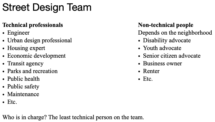
The origin the street design team is the Strong Towns post Engineers Should Not Design Streets. The upshot is that engineers do not have the training or expertise to design streets. Streets should be designed by everyone, and then the engineer will implement that design. The way to do that is to create a street design team with both professionals and citizens. The course presents this chart.

In the presentation, Mike Lydon recommended starting with designing streets that already have some good things about them, and making them better, rather than starting with horrible streets (stroads) that can take a lot of money and time to heal. Anthony Garcia said that if either engineers or politicians are not initially supportive, starting with a small project can show them that alternatives work and are supported by the public. He also said, don’t pick something really controversial or really challenging, rather, pick something likely to be successful.

The whole street design team concept is based on one of the core principals of Strong Towns, four steps for public investment.

for SacCity

I would say that the number of non-technical people should outnumber the technical professional. I would also include in the non-technical list the regional walking and equity organization, Civic Thread, and/or the regional bicycling organization, SABA, and/or one of the transit advocacy organizations. And I would include a member of the SacATC, which has 11 members. Non-technical people should be compensated in some way for their participation, such as stipends, food, transportation, child care.

People could speak up for being on a team, and then a team for each issue or block would be assembled from those available. Though team application and team formation could be managed by the city, they would not be in charge of the team. Though the concept does not specify how big the team should be, I find that teams of more than 12 people tend to have issues with hearing from everyone. Team members would have to agree to a set of group guidelines or community agreements about how to treat each other, with respect, listening more than talking.

A team might stay together for more than one project, or might do only one before the team members disperse to other projects.

Next step? I’m not sure. I intend to talk to some SacATC member and city staff about the idea.

Crash Rapid Response Program for SacCity

Note: This post has been significantly revised and published as two separate posts, one on OakDOT’s Rapid Response Program, and the second a proposal for a City of Sacramento program.

When a fatality or severe injury for walkers and bicyclists, people often ask, what can we do right now to prevent or reduce the severity of the next crash? This topic has come up a number of times at the Sacramento Active Transportation Commission (SacATC), and communication by Slow Down Sacramento, Civic Thread, SABA, and other organizations. I believe now is the time for the City of Sacramento to establish and fund a crash rapid response program.

OakDOT Rapid Response Program

The City of Oakland Department of Transportation (OakDOT) seems to have the best program I could find on the Internet. This is not surprising – since being formed in 2016, OakDOT has led on developing programs for safer streets that are informed by equity. So far I have not found a single document that describes the program and procedures, so I’ve selected some information from the Safe Oakland Streets (SOS) and related pages and documents. Safe Oakland Streets is Oakland’s version of Vision Zero.

Rapid Response Projects: OakDOT seeks to eliminate traffic fatalities and severe injuries while promoting safe, healthy, equitable mobility for all. OakDOT’s efforts to make streets safe include rapid responses to fatal and severe crashes involving the most vulnerable users of Oakland’s roadways. A Rapid Response is a coordinated effort in the days and weeks following a traffic tragedy that may include investigations, targeted maintenance, near-term improvements, and the identification and prioritization of longer-term capital needs.”

“A Rapid Response may be activated for traffic crashes resulting in pedestrian or bicyclist fatalities, or severe injuries to pedestrians or bicyclists who are youth or seniors. A Rapid Response may be activated for additional crashes based on the individual circumstances of a crash.”

The two elements most relevant to rapid response are:

  1. Maintenance Treatment: If the crash location has a maintenance issue that may be related to traffic safety e.g., pavement defect, faded striping, missing sign), the maintenance issue will be rectified by field staff.
  2. Quick-Build Improvement: If there are design treatments that could be implemented quickly at low cost, engineering staff will prepare the design and issue a work order for field staff to construct.

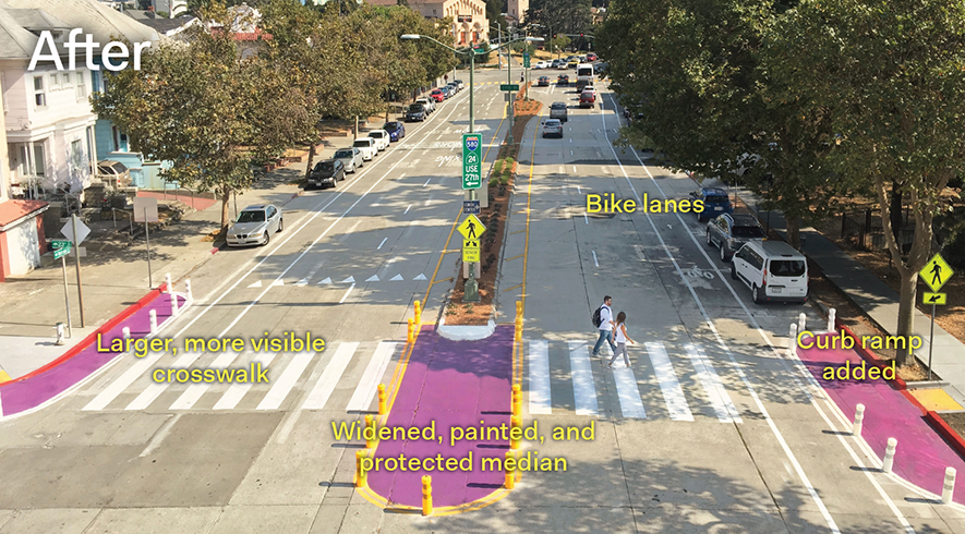
The following photos shows the setting after rapid response to a fatality that occurred at Harrison & 23rd. See Harrison & 23rd St Crash Response for more information.

photo of OakDOT rapid response project at Harrison & 23rd

OakDOT has a Crash Prevention Toolkit with photos of solutions, most of which are inexpensive and quick to implement.

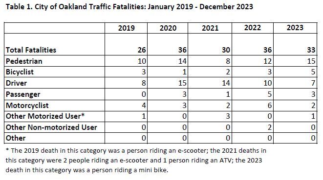
OakDOT offers a map with locations of fatality crashes and relevant features such as high injury network and equity, Traffic Fatalities, City of Oakland. A chart, below, also shows yearly data for modes of travel. A Crash Analysis Infographic also communicates data visually.

OakDOT chart of traffic fatalities by mode over time

SacCity program outline

The city program should start small to make sure that there are sufficient resources of staff time and funding to do a good job. I would suggest in the first year responding only to crashes on the high injury network. Yes, those will get fixed with grants, but those are very long term projects, whereas quick fixes are also needed. An alternative would be to do only fatalities, not severe injury crashes.

A rapid response team should be composed of at least three people. One must be a traffic engineer. Others could be planners, law enforcement, and a member of an advocacy organization (Civic Thread for walkers and SABA for bicyclists). Though the participation of law enforcement may not be useful to the outcome, it is useful for educating police about street design.

It is important that the team review existing documentation and make a site visit. The full law enforcement incident report will not be available within the rapid response time frame, but sufficient detail should be available to determine the movements of the people involved in the crash.

The team should make a report within five working days of the crash, listing obvious and inexpensive fixes, prioritized by effectiveness. One or more of the fixes should be implemented within 20 working days of the crash.

Public Works staff should report to SacATC on a yearly basis on the rapid response program, the projects undertaken, staff time, and money spent. After the first year, this information should be used to develop a budget request for future years.

City of Sacramento should create a fatalities map similar to Oakland’s, with frequent updates, from SacPD information. The state SWITRS database always lags too far to be useful.

A dashboard should be developed that includes fatalities and severe injuries by type of mode and trends. SacATC has already requested a dashboard that would also show projects applied for, in progress, and complete.

As with any new program, this one would and should evolve as experience is gained and the public sees the value of the program in reducing or eliminating fatalities.