Posts related to the work zone guidelines are linked via category ‘Work Zones‘ within City of Sacramento category. Posts about construction project issues, previous to and after the release of the draft guidelines, of which there are a huge number, are linked via tag ‘construction zone‘ within Active Transportation category.
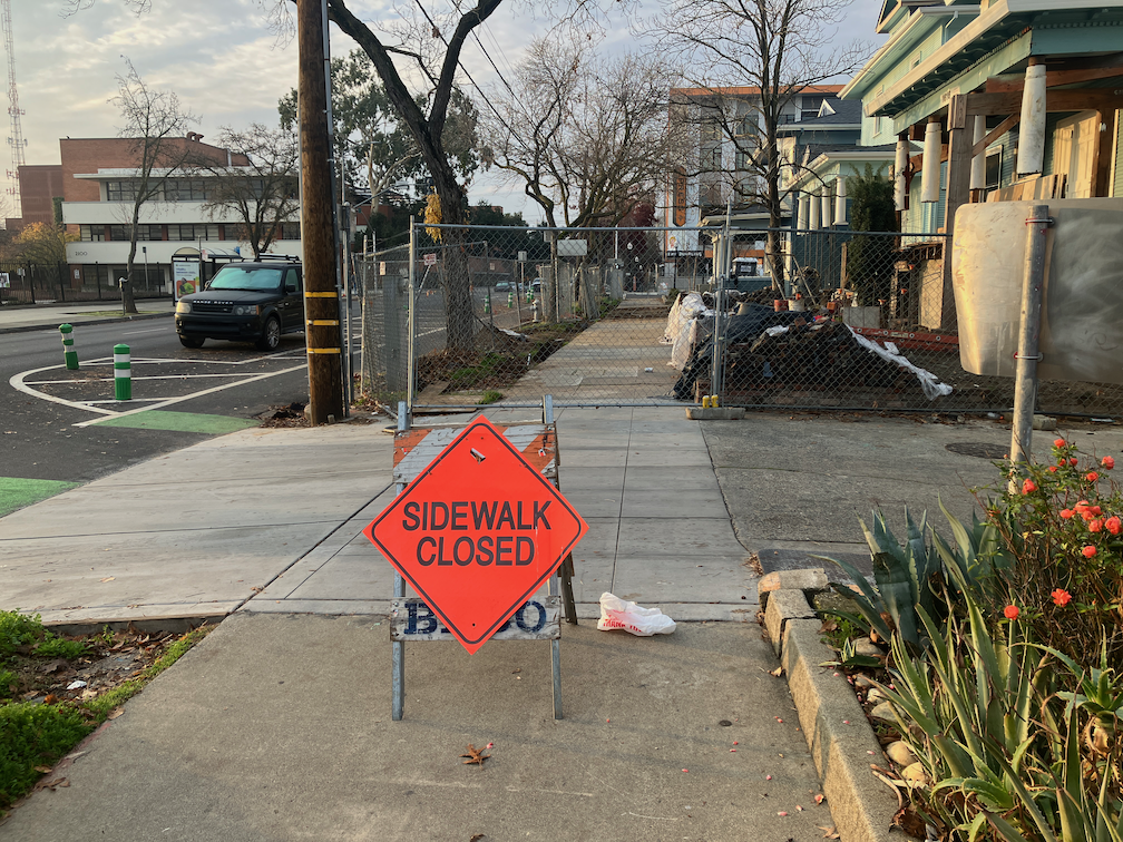
I walked a long section of Broadway today, and came across two construction projects that close sidewalks without proper and safe signing and barricades.
‘Dental Clinic Remodel’
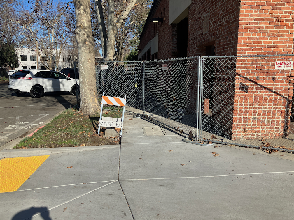
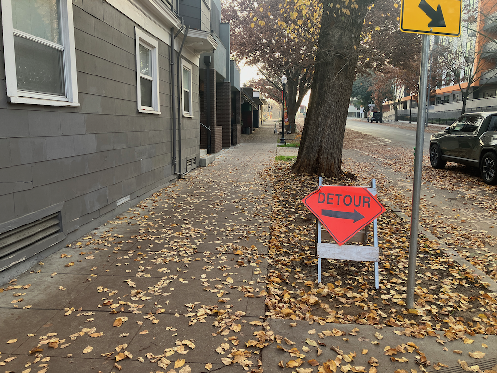
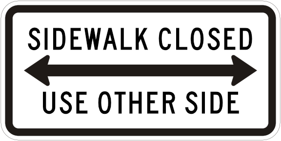
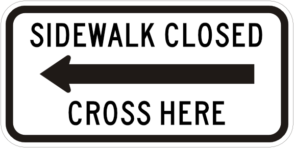
I put this one in quotes because it is a building that has been abandoned for years, but is apparently now under construction. Construction for this half-block building on the north side of Broadway between 23rd and 22nd Streets has closed sidewalks on both 23rd and 22nd. For 23rd, there is some signing, but also a non-detectable chainlink fence and trips hazard folding barricade. As with many other construction projects, a sign on hand, the bicycle/pedestrian detour sign (MUTCD M4-9a), was used though it is not required or appropriate. The sidewalk closed ahead cross here (MUTCD R9-11) is a valid sign, but the wrong location. The sidewalk is closed HERE, not ahead, so the correct sign is sidewalk closed cross here (MUTCD R9-11a).
work zone violation at Broadway and 23rd St, wrong sign, non-detectable barricade
At the corner of Broadway and 22nd Street, there is no sign at all, and the same non-detectable chainlink fence used as a barricade.
work zone violation at Broadway and 22nd St, no sign, non-detectable barricade
I did not check on the north side of these sidewalk closures, but I would assume the signing and detectability is the same or worse.
There is a new development occurring on the southwest corner of 16th Street and E Street, 30 affordable apartments, apparently called Studio 30. This is something that I always support, more housing, more affordable housing.
apartment construction at 16th St & E St, southwest, called Studio 30Read More »
Posts related to the work zone guidelines are linked via category ‘Work Zones‘ within City of Sacramento category. Posts previous to the release of the draft guidelines, of which there are a considerable number, are linked via tag ‘construction zone‘ within Active Transportation category.
The problem with work zones at this time, before the adoption of a new Guidance to Accommodate Active Transportation in Work Zones and at Events policy (https://www.cityofsacramento.org/Public-Works/Transportation/Planning-Projects/Work-Zone-and-Event-Detours), is that the city accepts incomplete and non-compliant Temporary Traffic Control Plans, and then does not monitor them for compliance. The success and safety of construction zones should not have to rely on the public reporting non-compliant locations, it should be the job of city staff to monitor compliance.
Monitoring
City staff should monitor construction zones at the beginning of the construction project when signs, barricades, and channelizing devices are installed, and at any point when there is a significant change to the locations closed or detoured sidewalks or bikeways. As an example, 9th Street between K Street and L Street changed dozens of times during the construction project, and in fact, the sidewalk at that location is still closed long after construction appears to be complete. Almost every change had one or more non-compliant aspects, though it did improve over time. At beginning of construction, the sidewalk and bikeway were closed without warning signs, and there was unrelated construction on the other side of the street which closed the sidewalk. This sort of issue should never have happened! It has long been a requirement to comply with MUTCD and ADA (even before PROWAG was finalized).
The draft guidelines define five work durations:
Long-term stationary is work that occupies a location for 5 days or more.
Intermediate-term stationary is work that occupies a location more than one daylight period up to 5 days, or nighttime work lasting more than 1 hour.
Short-term stationary is daytime work that occupies a location for more than 1 hour within a single daylight period.
Short duration is work that occupies a location up to 1 hour.
Mobile is work that moves intermittently or continuously.
I would not suggest that monitoring is necessary for durations C, D, and E, unless there is a citizen complaint about safety. For duration B, it should be inspected once, at the beginning. For duration A, it should be inspected at the beginning, and once per week thereafter. The additional monitoring would ensure that changes are captured and addressed, and that fallen signs, barricades or channelizing devices are corrected.
If there seems to be insufficient staff for monitoring, then the construction company must be charged more for the Temporary Traffic Control Plan and encroachment permit, sufficient to staff. The majority of construction is occurring in the central city, but there are locations throughout the city that must be monitored.
Enforcement
The draft guidelines do provide for administrative remedy, as follows. This will be sufficient, if Public Works staff follows through. However, in the past, staff has shown little concern for compliance, and has only responded to repeated citizen complaints.
Administrative Penalties Implementation of the requirements for accommodations within these criteria and guidance must be paid for by the construction sponsor and it must be the responsibility of the construction sponsor to comply with the requirements of these criteria and guidance. Should the construction sponsor fail to comply, the Public Works Director or their delegate has the authority to stop all work until compliance has been achieved (§12.20.020). Such work will not be resumed until the necessary modifications have been implemented (§12.20.020). The Public Works Director or their delegate may issue an order imposing an administrative penalty to any person violating any provision of Chapter 12.20 Closure of Primary Streets for Construction.
There is a construction zone at the northwest corner of Q Street and 21st Street which serves to illustrate what can go wrong with work zone signing. I am not picking on this particular construction site, as it is a rehabilitation of historical housing, which I fully support. I’ve seen worse construction sites, I’ve seen better construction sites, but this is a current example.
On Q Street at 20th Street, at the last crosswalk before the construction zone, there is the sign below. It is a roadway construction sign, not a sidewalk closure sign. Note that this sign was not here until I reported the location to 311. Following is the sign that should be here, MUTCD R9-11a.
Sac_Q-St-20th-St_advance-warningMUTCD R9-11a right sign
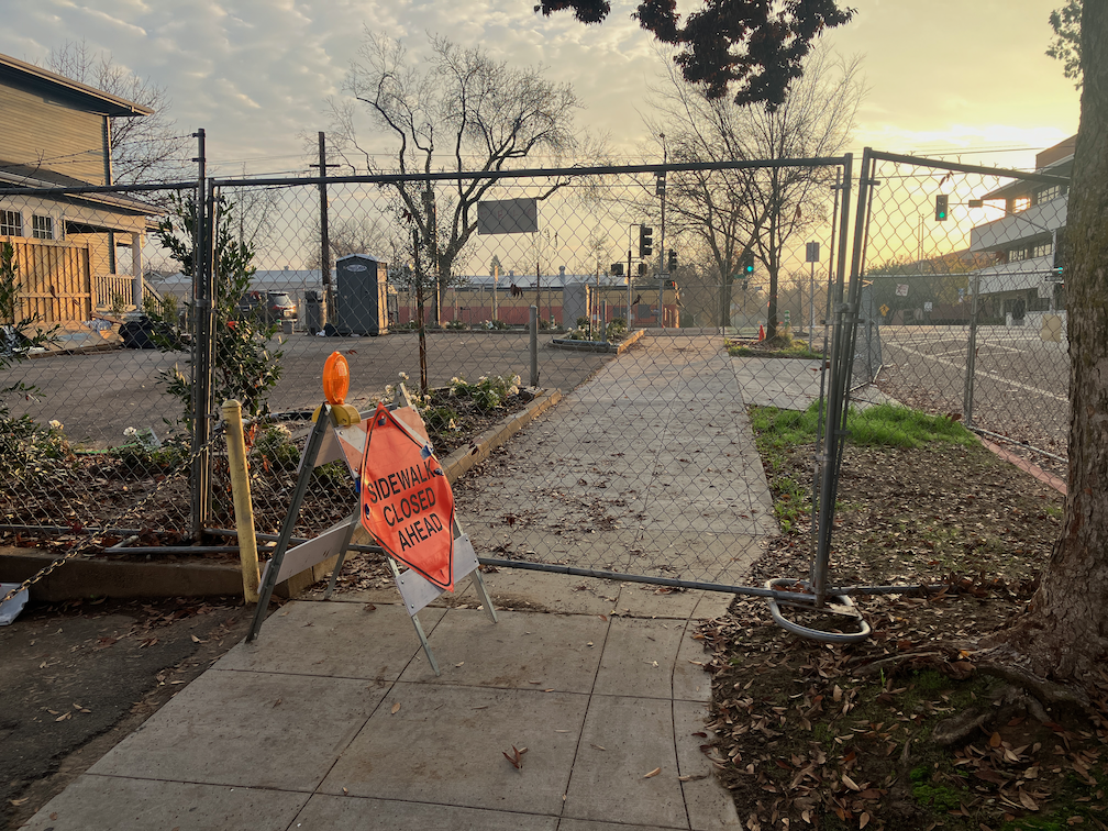
On Q Street approaching 21st Street, at the point of closure, there is this sign and a chainlink fence. This sign has been turned so it is not visible to someone approaching, and the traffic barricade on which it is mounted is a trip hazard. Following is the sign that should be here, MUTCD R9-11. Chain link fence is not an acceptable detectable barricade. Imagine using a long cane and running into this. What would you think? What would you do?
Sac_Q-St-21st-St_sidewalk closedMUTCD R9-9
For the crosswalk over Q Street at 21st Street, here is the sign. Note that this sign was not here until I reported the location to 311. Following is the sign that should be here, MUTCD R9-10.
Sac_21t-St-Q-St_sidewalk-closed aheadMUTCD R9-10
On 21st Street crossing at Q Street, north side, there is a sign on the ground that was intended to mark the closed crosswalk, before it was knocked down by the wind or by people. This is what happens when work zone signing is not monitored by the construction company. Note that this sign was not here until I reported the location to 311. Following is the sign that should be here, MUTCD R9-10.
Sac_21st-St-Q-St_sign-on-groundMUTCD R9-10
On 21st Street at P Street, there should be an advance warning sign. There is not. Following is the sign that should be here, MUTCD R9-10.
Sac_21st-St-P-St_no-advance-warningMUTCD R9-11a left
On 21st Street at Powerhouse Alley, where the sidewalk is closed, there is the sign shown below. Again, it is the incorrect sign, mounted on a traffic barricade that is in itself a trip hazard since it does not meet detectability requirements. The chain link fence is not an acceptable detectable barricade. Following is the sign that should be here, MUTCD R9-11.
The use of incorrect signs, missing signs, and lack of detectable barricades, are problems that could be corrected, if the construction company had a compliant Temporary Traffic Control Plan, and if the city monitored the location for compliance. More about that in the next post.
I’ve spent more time looking at the 2023 MUTCD, Part 6, Temporary Traffic Control. The document is a bit convoluted, and I didn’t realize there were references in several locations, which taken together though not separately, provide better guidance for sidewalk barricades.
Figure 6K-2 provides a diagram for ‘pedestrian channelizing device’. The example is for the side of a temporary walkway, shown curved (though Figure 6P-29 shows right angles).
In a separate location, the notes page for Figure 6P-29, the text reads, Standard 1 “When existing pedestrian facilities are disrupted, closed, or relocated in a TTC zone, the temporary facilities shall be detectable and include accessibility features consistent with the features present in the existing pedestrian facility. A pedestrian channelizing device (see Figure 6K-2) that is detectable by a person with a vision disability traveling with the aid of a long cane shall be placed across the full width of the closed sidewalk.” The same channelizing device can be used as a barricade to close sidewalks. Imagine the left-most panel in the diagram, extending across the width of the sidewalk. I think that the three examples I used in my previous post (SacCity work zone comments) would be compliant, though I am not certain.
Audible Warning
Another item of critical importance, that I did not initially pick up on, is the new requirement for audible warning: Notes for Figure 6P-28, Standard 5 (page 914): “SIDEWALK CLOSED CROSS HERE signs shall include audible information devices to provide adequate communication to pedestrians with vision disabilities.” The ‘sidewalk closed cross here’ sign is MUTCD R9-11a, which is the advance warning, used at the last available crosswalk.
The City of Sacramento is in a planning process that will lead to an active transportation plan, called Streets for People. It will replace the somewhat out of date Bicycle Master Plan and the prehistoric Pedestrian Master Plan. Phase 1 involved gathering input and specifics from the community, and resulted in an existing conditions report.
I have, to be honest, not participated in this process nor posted anything about it. Well, here you go! I’ll look more closely, and no doubt have things to say. Soon, I hope.
PROWAG (Public Right of Way Accessibility Guidelines), released in August 2023, has the force of law, whereas MUTCD and CA-MUTCD are advisory, so relevant sections of PROWAG must be referenced in the work zone guidance.
Signing
PROWAG Chapter 3 says: [R303.2 Signs: Signs identifying alternate pedestrian access routes shall be provided in advance of decision points and shall comply with R410. Proximity actuated audible signs or other non-visual means within the public right-of-way of conveying the information that identifies the alternate pedestrian access route shall also be provided.]
The draft guideline says: ‘Proposed design and placement of the temporary traffic control signs, devices, and roadway markings must follow the most recent edition of the CA MUTCD.’
The draft guidelines must make clear that CA-MUTCD/MUTCD signs as shown on the diagrams must be used. This is a common failing of construction zone signing. Companies, and the city, use whatever similar signs happen to be on hand. They use roadway construction signs, and paper signs that melt in the rain and blow away in the wind. Note: I submitted a comment to FHWA for the MUTCD revision that these signs should be construction orange, as they are temporary construction closures, not permanent. They didn’t listen.
Barriers
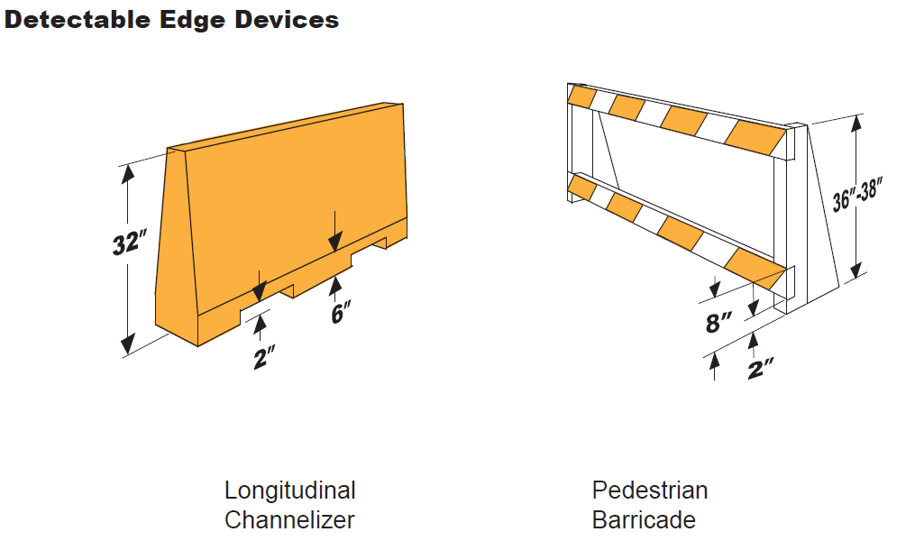
MUTCD text and figures show barriers in crosshatched orange. Unfortunately, neither MUTCD nor PROWAG show details of what that barrier should look like. It is common in construction projects to use chain link fence or roadway construction barriers on sidewalks, but these do not meet the requirements for detectability by persons using canes. Though PROWAG does not specifically address barriers (unfortunately), it does have the text: R303.6.1 Top: The top of the top detectable edging shall be no lower than 32 inches (815 mm) above the walking surface and be free of sharp or abrasive surfaces, and R303.6.2 Bottom: The bottom of the bottom detectable edging shall be 2 inches (51 mm) maximum above the walking surface.
There are two diagrams that I’ve used before, left and center. Right is a commercial product (though note is is only compliant if the props are away from the walker, otherwise they are a trip hazard). This model has been used in several places in Sacramento, but they tend to fall down in wind, so may not be the best. The channelizer in center is often used as a barricade at crosswalks, and I believe this use is compliant, and they don’t fall down in wind. The draft guidelines must include some sort of diagram, otherwise, companies will use whatever is on hand, and whatever a sighted person thinks is sufficient.
The sidewalk diagram in the new 2023 MUTCD Figure 6P-28 is better than the 2014 CA-MUTCD Figure 6P-28 because it makes clear that ramps from sidewalk level street level are necessary for a diversion. That diagram is below, and should replace the one in the draft guidelines. Figure 6P-29 is the same in both.
These are my posts on Yolo 80 Managed Lanes Project, or related and relevant. The category ‘managed lanes‘ will surface most of these posts, and future ones if there are any. My main purpose is to inform the public so we will be better informed for the next project (and there will be a next project). The only thing that might stop the Yolo 80 project is a lawsuit or lack of funds. Public opinion will not stop it.
I now will get back to other issues that I’ve been neglecting while focused on Yolo 80 and managed lanes.
All-lanes tolling means that all lanes of a freeway or bridge are tolled, or priced. Freeways and bridges are incredibly expensive to build and maintain, even if they are not way over budget as most bridges and many freeways are. Gas tax or road charge (road charge) will never be enough to pay for these infrastructure projects and maintenance. Therefore, more than half of the cost is shifted onto taxpayers who use less of these facilities, or don’t use them at all. In the future, either more and more taxpayer funds will go to keeping these facilities in state of good repair, or they will deteriorate, which is already happening in many places. The solution is to have the users of such facilities pay the full price of such facilities.
Caltrans approach to transportation is to continually build more and to under-maintain what they already have. Anyone who says the era of big, expensive bridge and freeway projects is at an end doesn’t know Caltrans. Caltrans is like the heroin addict who needs ‘just one more hit, and then I’ll quit’. The only solution is to have Caltrans go ‘cold turkey’, ceasing all freeway expansions and focusing on maintenance. Of course most Caltrans engineers would be suddenly superfluous, and that it the real issue, that freeway and bridge building is just an employment program for engineers, having little to do with meeting the needs of the traveling public.
Road charge is not a tolling system. It charges per mile driven, no matter what the classification of roads (freeway, arterial, collector, local). The California gas tax funds maintenance of mostly large infrastructure, bridges and freeways, but to a lesser degree surface arterials, collectors and local roads. In every place in California, the gas tax, as well as motor vehicle fees, pays for only about half of the cost of roadways. The rest is paid for at the county and city level, by all taxpayers regardless of how much they drive, or even if they drive. As such, transportation funding is in part a subsidy to motor vehicle drivers by people who don’t drive. The same is true at the federal level, where gas tax accounts for less than half of the highway trust fund. The inflation adjusted yield of federal gas tax has been declining since 1994.
A road charge, which drivers pay when they actually use the roadways, is an equitable system because every driver can choose, to some degree, to drive more or less. Though many low income people live in locations where access to jobs and other destinations is difficult without a car, there is always some choice involved. That doesn’t mean there are no equity implications, but a road charge is definitely more equitable than the gas tax because high income people can afford higher gas mileage or electric vehicles, whereas low income people cannot.
Many road charge proposals charge all vehicles the same per-mile rate. This is not equitable. The damage to pavement, and the pollution generated by tire and brake wear, is directly related to the weight of the vehicle. Big rig trucks cause many times more damage to roadways, and produce many time more tire and brake dust, than passenger vehicles. And large SUVs, so popular these days, also produce much more roadway wear and tear and tire and brake dust. And of course since electric vehicles weight considerably more than fossil fuel vehicles, they also produce more. Therefore, road charges should be ‘weighted’ by the weight of the vehicle. This information is available for every vehicle, as it is required when registering; yes, people can modify to create heavier weight, but the initial weight is close enough. Caltrans claims that all vehicles under 10,000 lbs GVW cause the same amount of road damage, even the elephantine electric Hummer, but this doesn’t pass the smell test. The standard calculation is that road wear goes up as the square (conservatively; fourth power is well documented for heavy trucks) of the weight. So the Hummer (9500 lbs) causes about 100 times the damage of a Prius (3000 lbs). Even at the conservative second power, it causes 10 times as much damage. Heavier vehicles of course also require that bridges be built for heavier loads, increasing their built cost as well as maintenance.
California has carried out one road charge pilot, a demonstration for different charging mechanisms, and is soon to start another pilot. It is hard to say when a road change might be implemented across the state. It has a lot of opposition from drivers who think the roadways should be free and that others should pay instead, or that gas tax covers infrastructure needs, which is only partially does.
San Diego County (SANDAG MPO) was slated to start a road charge for that county, but the board chickened out and removed it from the regional transportation plan draft. However, it is unlikely the plan will be accepted by the state unless it is either returned, or a viable alternative is proposed (KPBS: SANDAG board nixes ‘road usage charge’ from transportation plan).
It is a universal truth that drivers don’t want to pay the true cost of their driving. An appropriately designed road charge comes closer to the true cost than anything else.
A reminder: A road change is different from tolling/pricing. The road charge applies to all roadways at all times. Tolling applies to high cost infrastructure such as bridges and freeways, and may vary with time or other criteria.