The City of Sacramento Active Transportation Commission (SacATC) will meet this Thursday, March 12, starting at 5:30 PM. This is not the usual third Thursday, but the second. The meeting may be held in the old city hall, rather than council chambers, but the agenda is not clear about that.
The agenda is below (pdf). I have not had a chance to look at the four agenda items to make comments here, but will if I am able. The linked items contain both staff reports and presentations. I find it useful to separate these into two documents, but again, only if I have the time. All of these are review and comment items, not for decision.
The City of Sacramento Budget and Audit Committee will consider the recommendations of SacATC (Sacramento Active Transportation Commission tomorrow, Tuesday, March 10. The commission is asking that the city invest in implementing the recommendations of the report. Though Sacramento seeks grants to improve street safety, that process is slow and not always successful. The city’s new quick-build program is a first step forward, but not yet active. We cannot afford to wait while people die and are severely injured on our streets.
The email from Slow Down Sacramento/Isaac Gonzalez is included below, and has all the information you need.
On Tuesday at 11:00 a.m., the Sacramento City Council’s Budget and Audit Committee will consider recommendations from the Active Transportation Commission’s 2025 Annual Report. These recommendations focus on funding practical steps that would make Sacramento’s streets safer for people walking, biking, and rolling.
The commission is asking the City to invest in proven safety strategies, such as expanding traffic-calming tools, strengthening the city’s quick-build program, developing a citywide Safe Routes to School effort, and implementing safety improvements, such as Leading Pedestrian Intervals at traffic signals. These are not abstract ideas. They are practical tools that cities across the country are using to reduce serious injuries and save lives. Right now, none of these recommendations have identified funding attached to them. That means the Budget Committee will play an important role in deciding whether these ideas move forward or remain just another report sitting on a shelf.
If you care about safer streets in Sacramento, this is a moment where public voices matter.
Budget and Audit Committee Tuesday at 11:00 a.m. Sacramento City Hall 915 I Street
Even a brief statement reminding decision-makers that street safety matters to Sacramento residents can make a difference.
Why this matters Sacramento has declared a Vision Zero goal of eliminating traffic deaths, yet serious injuries and fatalities continue to rise. The Active Transportation Commission’s recommendations outline practical steps the City can take now to address dangerous streets and protect people who simply want to move through their neighborhoods safely. Plans alone do not save lives. Investment and action do.
If you are able, please submit a comment or come to City Hall on Tuesday and speak up for safer streets. Thank you for continuing to stand with us.
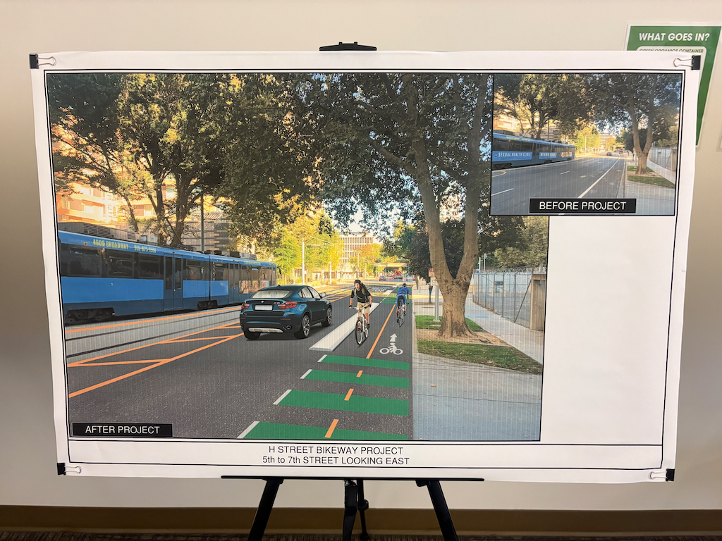
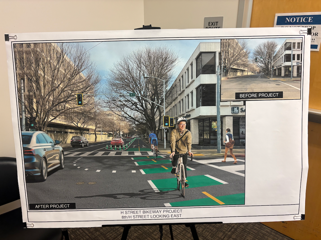
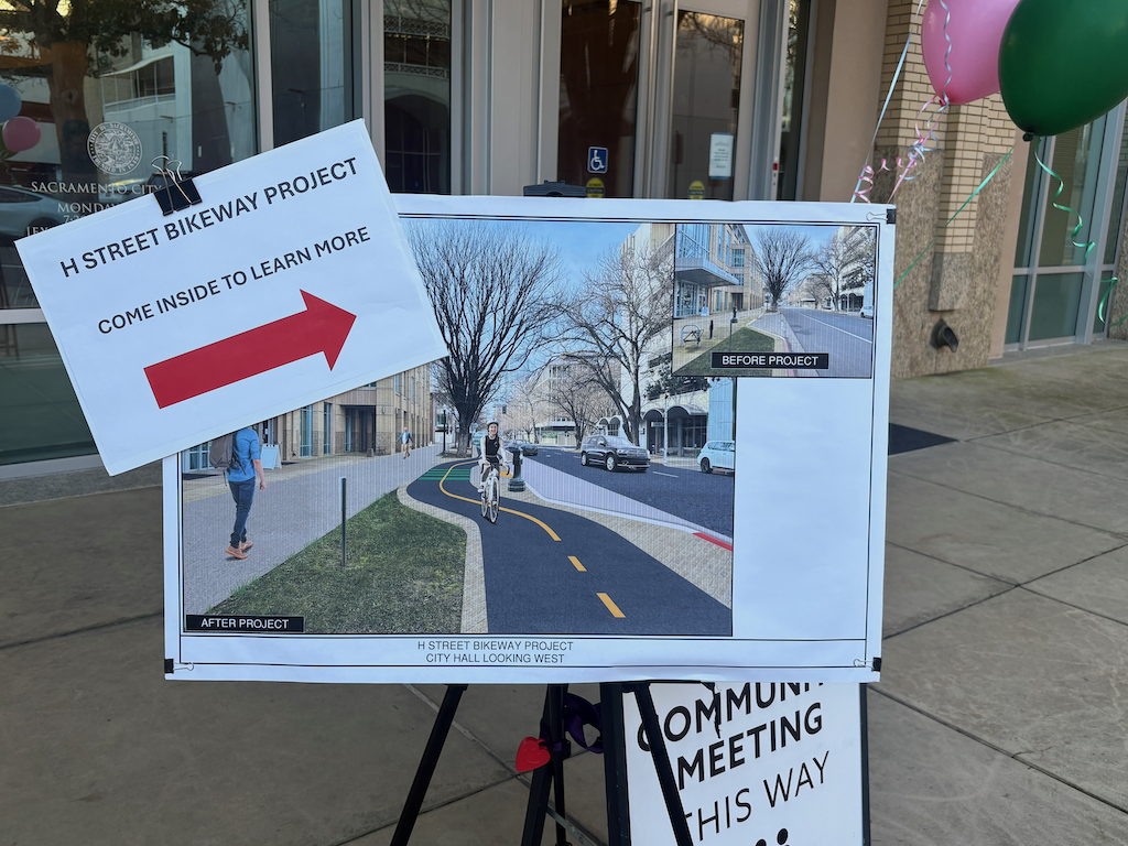
A workshop on the H Street Bikeway was held Thursday, February 26. There were at least 30 members of the public who attended, which is pleasantly surprising, indicating strong public interest in the project. Most workshops have far less participation.
The group presentation was brief. Most of the discussion was with city staff and consultants at the display boards. There were some renderings which I had not seen before, below. None of these three is the same as the rendering shown at the top of the project page.
I did not capture the display boards showing each block segment. They are very similar to the ones presented at the SacATC meeting, but some corrections and enhancements were made after feedback from that meeting. Among them:
A 10 foot width will be maintained throughout the project, except 9th to 10th Streets, where the bikeway is at the level of and within a pedestrian area, where a narrowing may help maintain lower bicyclist speeds.
Every intersection will have bicycle signal faces; this was an oversight in the images.
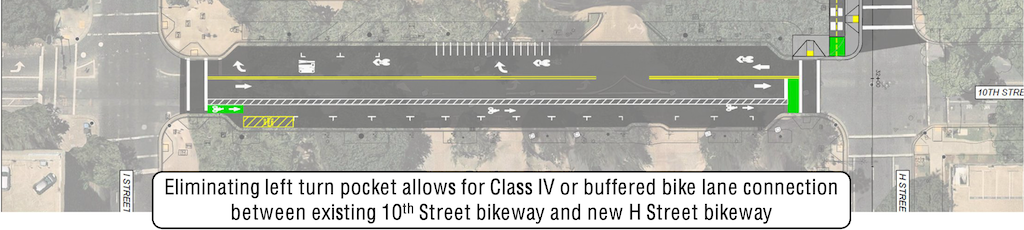
An alternative was proposed for 10th Street, narrowing the east side parking in order to create a buffer on both sides of the bike lane. The option to place the bikeway against the curb, for parking protection, was much discussed but is so far not the option being presented.
There are other details. Hopefully the brief presentation and the updated images and cross-sections will be posted to the webpage.
A lot of discussion between the public and the staff and consultants revolved around the issue that a clear design criteria was the preservation of parking. The lead consultant, Mr. Wright, mentioned a number of times how they had managed to preserve parking. This is sad. The purpose of the TIRCP grant is to enhance transit and active transportation access to the station. Preservation of parking is not one of the criteria. I don’t object to street parking. It has the safety problem of vehicles entering and leaving, but also has the safety benefit of slowing traffic due to the perceived friction. However, when roadway width is needed for other purposes, such as sidewalks and bikeways, it should be removed or reduced.
The primary reason for the right turn lanes at 7th Street and 9th Street is so that bicyclist can move while the straight through motor vehicle traffic is moving, but not when right turns are prohibited. The city feels that creating an exclusive bicyclist phase, where only bicyclists are moving and motor vehicles are stopped in all directions, would slow traffic too much.
For these two right turn situations, blank-out no right turn signs will be used. The city recognizes that regular no right turn on red signs don’t have much effect on driver behavior, but the blank-outs do. See no turn on red for Sacramento? for more info on blank-out signs. One is installed on Broadway at Land Park Drive (more on Broadway-Land Park bike signal).
To everyone who came, asking questions and providing opinions and experiences, thank you! Improvements may be incremental, but without you, they would be none.
The SacRT Safe Routes to Transit (SRTT) Plan held its first workshop on February 24 in Rancho Cordova. I attended the Rancho Cordova workshop, not because I live in that area, but because it was the only one that worked for my schedule. There is a virtual workshop on March 4, 5:30 PM to 7:00 PM (registration), and three in-person workshops on March 5, 10, and 11.
I was the only member of the public at the workshop in Rancho Cordova. That is sad.
The workshop had some display boards, two showing bus and light rail stops in two areas, captured below.
What the workshop, and the program, was soliciting was input on specific stops. What was not solicited was policy ideas, but I provided them anyway.
The most important policy for SacRT to implement is that all bus stops located on arterial roadways (which is most though not all bus routes) must have safe crossings of the roadway located very near the stop. Stops away from safe crossings encourage riders to cross mid-block (which is not illegal, but is not safe), or require them to walk distances to a safe crossing. I suggest that every bus stop be evaluated, and changes made. Either a safe crossing would be provided, or the bus stop removed. There are many locations where no safe crossing exists anywhere close to the stop. Implementation of safe crossings would require cooperation between SacRT and the local government (cities and county). There should be a deadline for identifying a solution, and implementing the solution. I’d suggest two years, and five years.
Though not common in the cities, there are legacy bus stops in the county that do not have sidewalk access, at all. Those stops must either be provided with new sidewalks, or be removed. Again, there should be a deadline. I’d suggest five years.
I asked if SacRT had talked to riders on the bus to gather information for this project. The answer was no. Apparently this was done in the past, but not recently, and not specifically about this issue. Advocacy organizations have surveyed bus riders on the bus, but not on this specific issue.
The two light rail stations about which I have safety concerns are Swanson and Watt/I-80 West. Not because of access, but because they are so seldom used that a rider might well be the only transit user there at the time. That doesn’t feel safe. There is safety in numbers! I question whether these two stations should be kept open.
Bus stop amenities are critical for encouraging people to ride, but are not necessarily safety issues. Every stop should have a place to sit. Most stops should have a shelter and trash can. Some stops should have bike racks and live arrival displays. Many stops do not have enough space for a a wheelchair user to wait safely for ramp deployment. This must be fixed. Placing amenities often requires a bus stop pad wider than the sidewalk (sidewalks throughout the county are often narrower than desired). Sometimes the pad will fit within the public right-of-way, but often it requires either purchase or an easement on private property. The government agency should be responsible for the arrangements, and placing the concrete pad, not SacRT. SacRT would then place amenities.
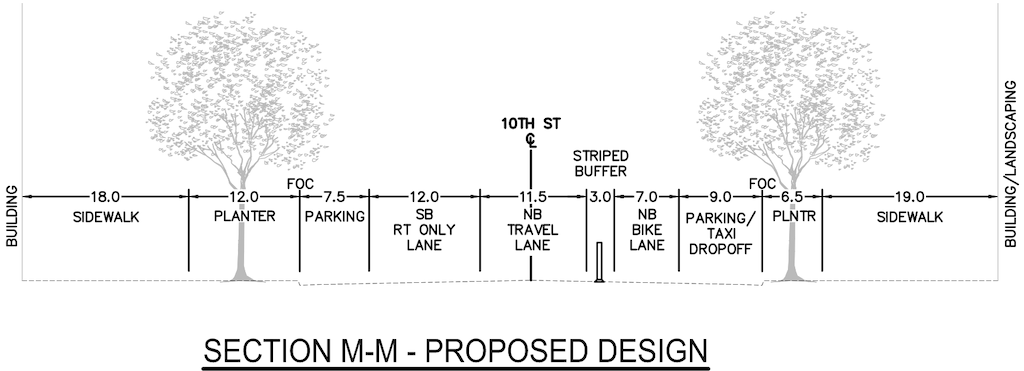
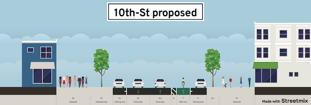
The 30% design for the 10th Street connection to the H Street Bikeway is shown below (these were also in the overview post H Street Bikeway: overview). The overall width of the roadway is 105.5 feet, and the ‘FOC face of curb’ width is 50 feet. The street narrows to 34 feet at the curb extensions at I Street and H Street.
H St Bikeway 10th St section, proposed (from SacATC presentation)H St Bikeway, 10th St section, proposed, 105.5 feet (from SacATC staff report)
I have created a StreetMix cross-section duplicating the design cross-section so that it can be compared to an alternative recommendation.
H St Bikeway, 10th St cross-section, proposed (StreetMix created by Dan Allison)
The design proposes a 7 foot bike lane northbound, with a 3 foot stripped buffer, and a parking lane to the right against the curb. Despite the cross-section showing a vertical delineator in the buffer, this is not possible with a parking lane to the right of the bike lane. The bike lane continues the separated, mostly parking-protected, bikeway from the south, which is a good thing. But a buffered bike lane is less safe than a separated bike lane, so detracts from the safety and low-stress goals of the project. The design encourages drivers, whether parking or drop-off/pick-up, to cross the bike lane, a poor practice.
Instead, the design should create a parking-protected separated bikeway. This reduces the utility for drop-off/pick-up, but an larger area could be set aside in the parking lane for this purpose, and the conflict zone crossing the bikeway can be clearly marked. Bikeways that swing into the curb past curb extension, and out again past curb extension, feel awkward for bicyclists, but they have been installed in several locations along the separated bikeway network, and don’t seem to engender safety issues.
The design also proposes sharrows within a southbound general purpose lane. You will have to look closely at the image to see the sharrows, but there are there. They are placed far to the right, in the door zone. This is a very poor design. New sharrows should not be installed, as they don’t decrease crash risk over unmarked routes. If they were there, they should be placed in the exact middle of the travel lane, and supplemented by ‘bicycles allowed use of full lane’ signing (MUTCD R9-20). to make is clear that drivers should not be passing bicyclists in this block. It is particularly likely that drivers will squeeze out bicyclists against the curb extension at I Street. An alternative is to stripe a narrow 5 foot bike lane, without buffer or protection, marked with green. Not ideal, but better than sharrows.
The design retains existing parking. Though it is not clear that removing parking would allow a better design, this should always be a consideration. There is ample and never-full parking in the city garage on the south side of I Street between 11th and 10th Streets. The curb extensions at I Street and H Street are critical features for the safety of walkers, but they do constrain design in this block.
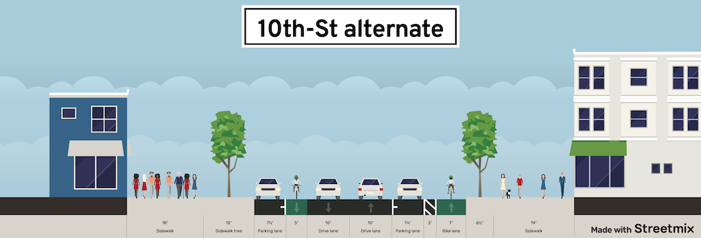
My suggested design is below.
H St Bikeway, 10th St cross-section, alternative design (StreetMix created by Dan Allison)
I do not have the time it would take to create an image of the street with the new design, but I think the cross-section will communicate clearly enough.
What is different? A southbound traditional bike lane (Class II) has been added. Both general purpose lanes have been reduced to 10 feet. There is no reason for over-wide lanes in this section. No buses, no delivery. The east side parking lane, an over-generous 9 feet, has been reduced to 7.5 feet. And the parking-protected separated bikeway is up against the curb, still with a 3 foot buffer from parked cars.
The H Street Bikeway project extends from 5th Street to 10th Street along H Street, and along 10th Street from I Street to H Street. It is intended to improve transit connectivity by double-tracking two blocks of light rail between 5th Street and 7th Street, and to improve bicycle access by providing a two-way separated bikeway (cycle-track) on H Street, which links to bikeways or bike lanes on 9th Street (southbound) and 10th Street (northbound). The project provides a reasonable solution, though it could be improved in a number of details (see H Street Bikeway: overview).
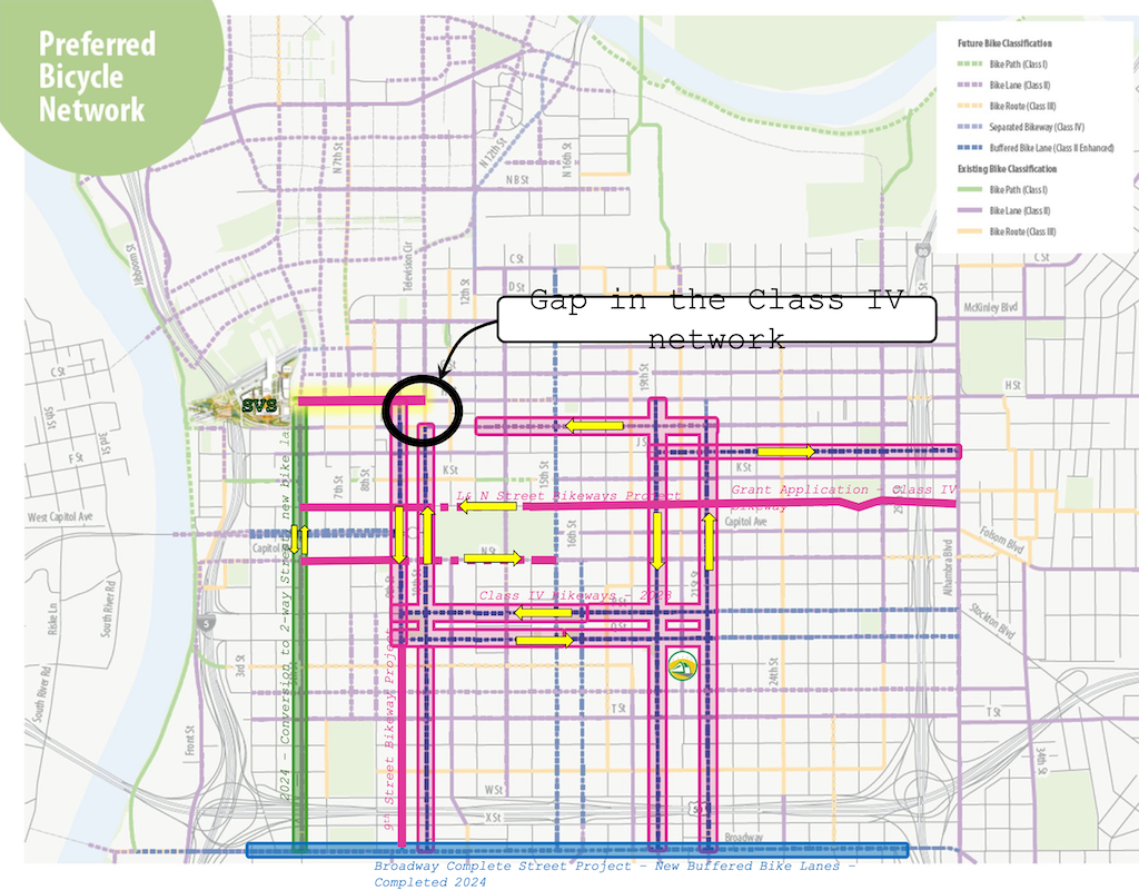
A map in the SacATC presentation shows the bikeway network in the central city, highlighting the gap on 10th Street from I Street to H Street.
Preferred Bicycle Network, showing gap on 10th St between I St and H St (from SacATC presentation)
It does not highlight the glaring gap on I Street between 12th Street and 10th Street. The separated, parking-protected bikeway on I Street, that starts at 21st Street, ends at 12th Street (it is just a bike lane in front of the fire department just west of 13th Street, but resumes further west).
For a bicyclist wanting to access the proposed two-way separated bikeway on H Street, they must use regular Class II (paint only) bike lanes from 12th Street to 10th Street, then proceed north one block in a buffered bike lane to H Street. I Street between 12th Street and 10th Street is three general purpose lanes. As it typical of any three-lane one-way street, motor vehicle speeds are well above the posted speed limit of 25 mph, except when congested. By the way, it is not posted at all in this section, though the change from two lanes to three lanes at 12th Street would make posting logical if not imperative.
There are other gaps, including 9th Street south of Q Street, and L Street and N Street. The map refers to a L & N Street Bikeways Project, but neither the planning or engineering sections of Public Works seem to have a webpage on that project. Strangely, the streets adjacent to Capitol Park are shown as Class II, paint only bike lanes, though these two sections without mid-block driveways are the most logical place for separated bikeways in the entire city.
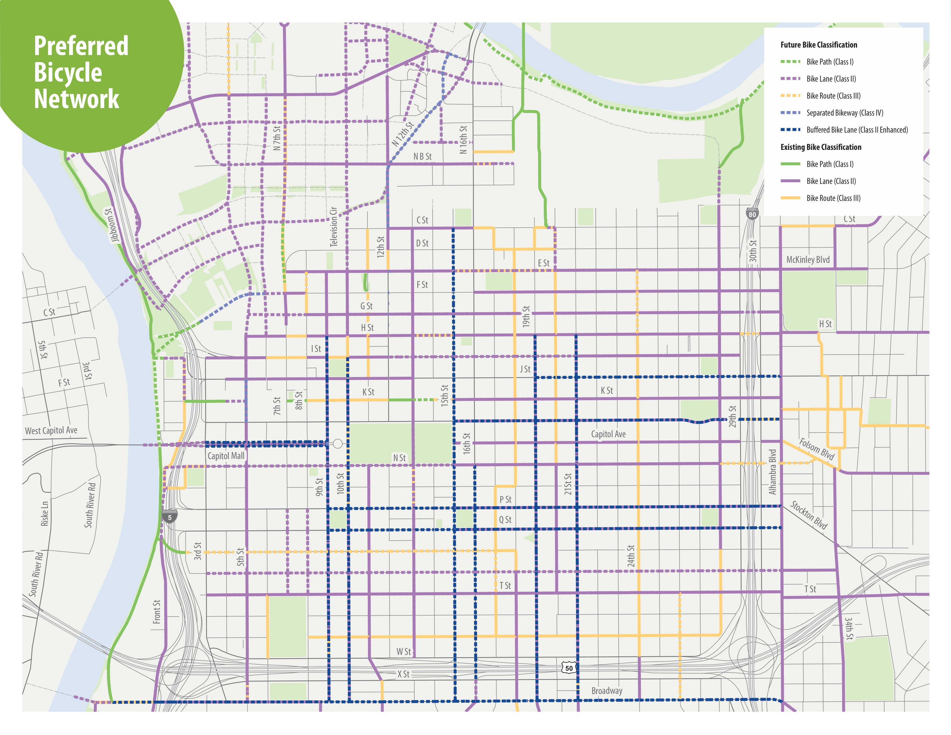
The map from the H Street Bikeway project presentation at SacATC was adapted from an old Grid 3.0 map (2016), below.
Grid 3.0 map of central city preferred bicycle network
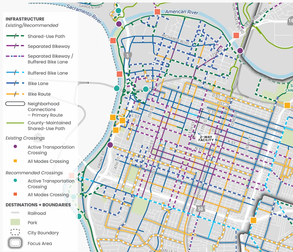
A more up-to-date map, with legend, is in the Streets for People Active Transportation Plan, page 80, ‘Figure 30 – Recommendations for People Biking in Central West Sacramento’, excerpted below. This map shows a separated bikeway (purple) continuing from 21st Street to 9th Street.
In designing a safe and welcoming two-way bikeway (cycletrack), design of intersections is critical. This post highlights the intersection. Both the staff report and presentation diagrams split the roadway at the intersections, obscuring the intersections themselves. The diagrams below show the intersections, and not the blocks in between the intersections. The diagrams are from the presentation, which offer more details about the intersections than the staff report. The images are rough because I glued together two parts which were not the same pixel resolution, but they provide a good idea of the intersections.
Key points:
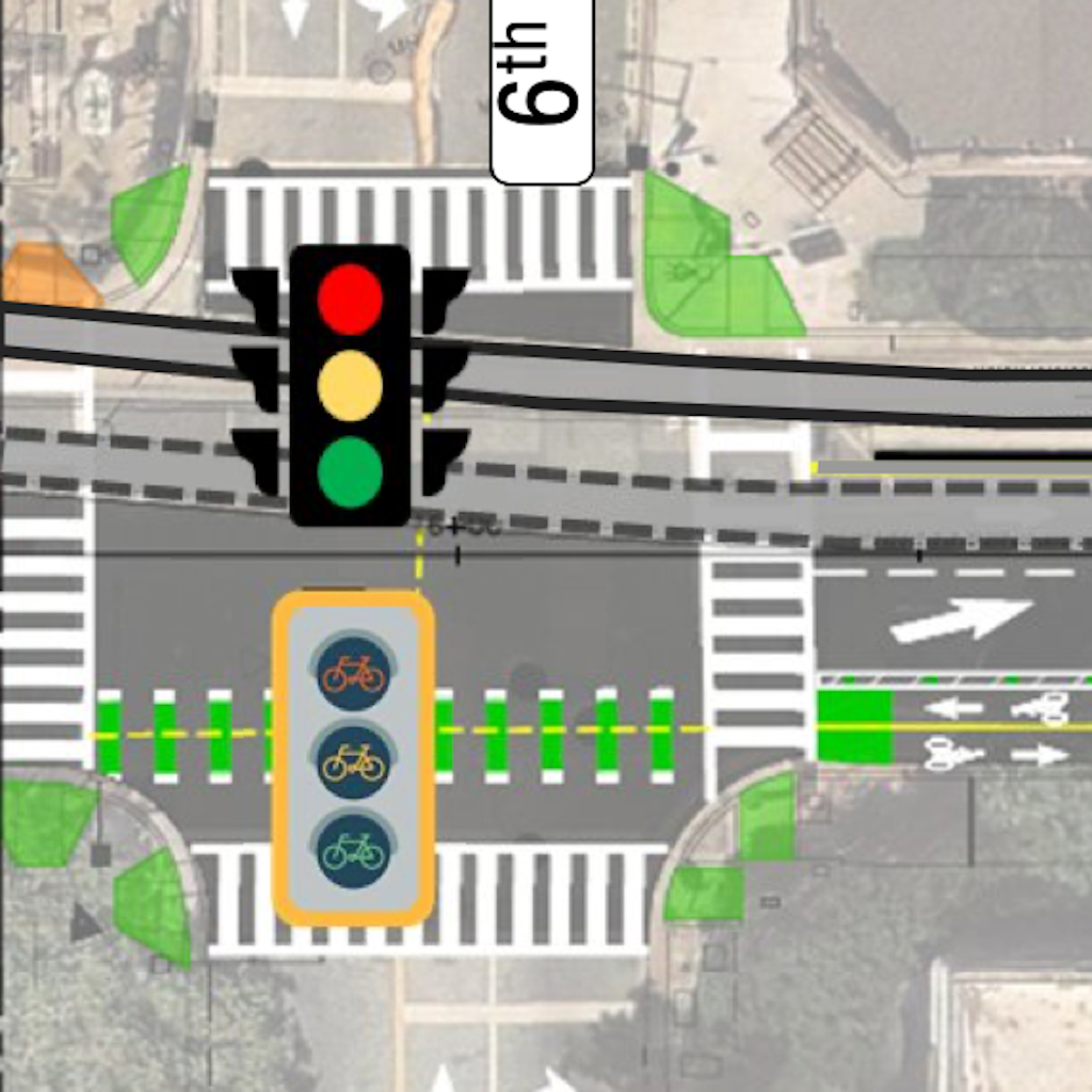
bicycle signal faces are required at every intersection from 5th Street to 9th Street, but are indicated only at 5th Street and 6th Street
protecting bicyclists is particular critical at 7th Street and 9th Street to guard against right turning drivers heading southbound onto these one-way streets
5th Street: This intersection has a bicycle signal face for the two-way bikeway. The transition from the bikeway to Sacramento Valley Station looks awkward, and will be until the station itself is revised, which is also part of the TIRCP grant project.
H St Bikeway, 5th St intersection, proposed (from SacATC presentation)
6th Street: This intersection has a bicycle signal face for the two-way bikeway.
H St Bikeway, 6th St intersection, proposed (from SacATC presentation)
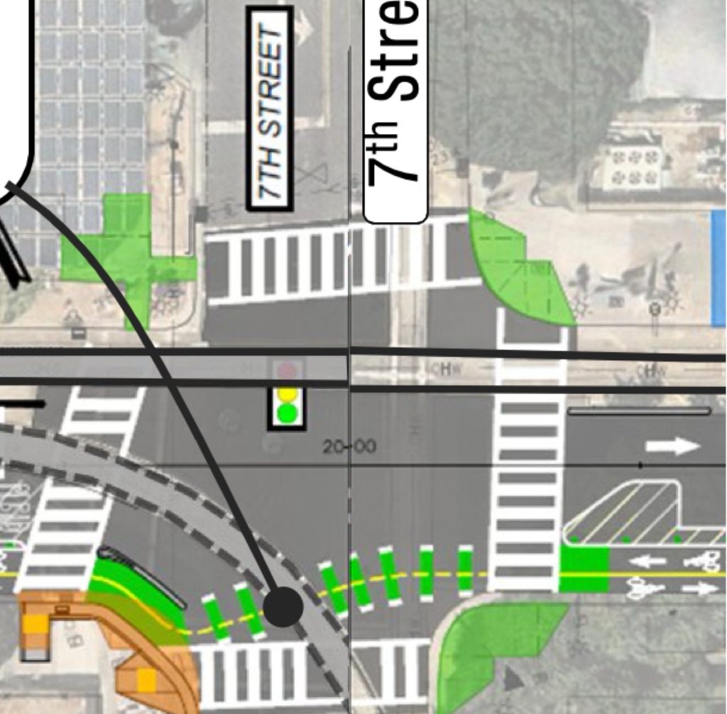
7th Street: This intersection does not have a bicycle signal face. It is particularly required here to protect bicyclist against drivers turning right onto 7th Street. No turn on red signing would not protect bicyclists on the two-way bikeway. 7th Street is one-way southbound south of H Street, and two-way north of H Street.
H St Bikeway, 7th St intersection, proposed (from SacATC presentation)
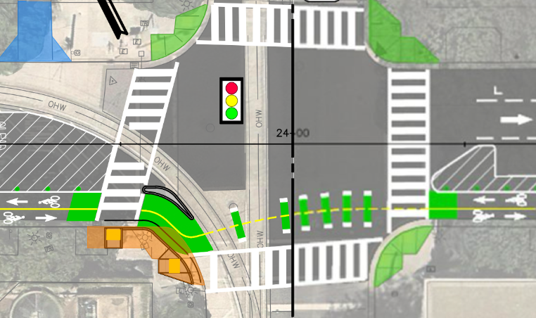
8th Street: This intersection does not have a bicycle signal face. 8th Street is one-way northbound.
H St Bikeway, 8th St intersection, proposed (from SacATC presentation)
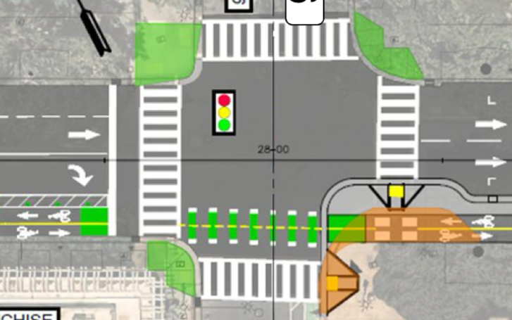
9th Street: This intersection does not have a bicycle signal face. It is particularly required here to protect bicyclist against drivers turning right onto 9th Street. No turn on red signing would not protect bicyclists on the two-way bikeway. 9th Street is one-way southbound to the south of H Street, but two-way to the north of H Street.
H St Bikeway, 9th St intersection, proposed (from SacATC presentation)
The H Street Bikeway design has 6 driveways crossing it, 2 on 5th Street to 6th Street, 3 on 6th Street to 7th Street, 1 on 7th Street to 8th Street, and none on 8th Street to 10th Street. Though none of these driveways are heavily used, all are potential conflict points for the bikeway. The 30% design diagrams do not detail how these driveways crossing the separated bikeway will be handled. It is imperative that motor vehicles using the bikeway are moving slowly enough that drivers will see and yield to bicyclists, and bicyclists have time to avoid collisions with drivers who do not yield.
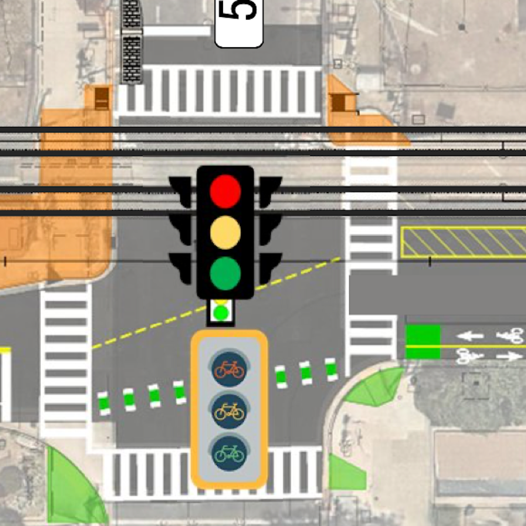
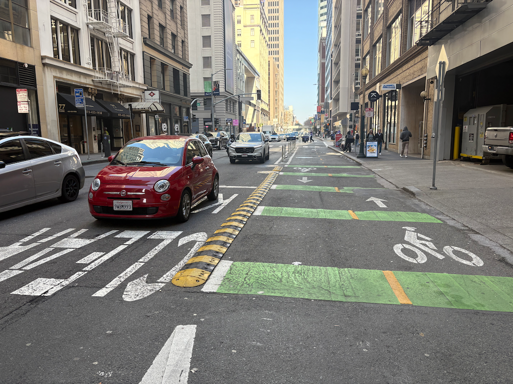
San Francisco has a two-way separated bikeway (cycletrack) on Battery Street in the financial district. Each driveway has speed control devices to ensure that drivers are moving slowly entering and exiting the driveways. The photo below shows one installation, between Pine Street and Bush Street. As a frequent user of this bikeway, I can attest that they are a critical safety feature.
A note about speed bumps. Speed bumps are illegal across roadways in the US. They are most often seen in parking lots, where they are still legal. This use across driveways, and not streets, is legal. The traffic calming devices that are legal across roadways are speed humps, speed cushions, and speed tables.
speed bumps across driveway on Battery St two-way bikeway, San Francisco
When a traffic crash results in a fatality, society mostly shrugs and moves on. Until Ariane Lange started writing in the SacBee about the victims of traffic, there wasn’t even a shrug. Sometimes all the evidence of someone dying is some small car parts pushed to the side, and maybe a small oil slick, easily ignored. There is nothing to say someone died here. The people who died might be drivers, passengers, walkers, bicyclists. Real people whose lives were cut short. It is likely for two reasons: roadway design that encourages speeding and reckless driver behavior, and human mistakes.
Rather than shrugging and moving on, we need to take notice. I think the best way is to close the intersection where the fatality occurred, and yes, it is quite often though not always, intersections. They are the locations with the most complex movement of motor vehicles, particularly turning movements, and walkers and bicyclists. The intersection should be closed until some action is taken to make the intersection safer.